
SAE accelerates our nation’s environmental information services by designing and developing the next generation of Earth observation and data information systems.
SAE provides a systematic approach to requirements, satellite architecture planning, and systems engineering. This approach is used to provide critical business information and analysis to support NOAA and NESDIS’ strategic observing system investment planning.
SAE's Story
The Overview

The NESDIS Office of Systems Architecture and Engineering (SAE) serves as the lead systems engineer and architect for NESDIS and the broader NOAA remote-sensing, data, products and services enterprise. In 2023, SAE was created from the reformulation of the Office of Systems Architecture and Advanced Planning (OSAAP) within a broader NESDIS reorganization to better focus resources on improving mission, execution, and operations.
The Past
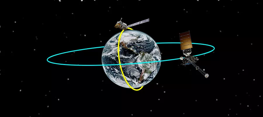
Since its inception, NESDIS has operated satellites in two primary orbits—first, in Low Earth Orbit (LEO) and then in geostationary orbit (GEO). Over four generations of satellites, NESDIS has evolved these LEO and GEO capabilities and their unique ground systems to the state-of-the-art systems providing critical data today.
In 2015, NESDIS expanded the realm of orbital domains to include “Deep Space” observations from the Lagrange 1 orbit located between the Sun and Earth to provide critically needed monitoring of solar and space conditions impacting the Earth.
Today
Demand is increasing for newer, faster, and more reliable weather, climate, and space weather services. At the same time, greater capabilities are emerging in both commercial aerospace and among our strategic international partnerships, as technology rapidly evolves. These trends both necessitate and enable a new approach to developing the next-generation of NOAA’s operational Earth observation systems that will improve the products and services we provide.
The NESDIS Vision
NESDIS is transitioning the organization to apply enterprise approaches that enable provision of an enhanced portfolio of Earth and space environment observation products and services that address user needs. SAE is the lead program office charged with identifying and developing the enterprise system that will meet user needs by leveraging U.S. space-based operational environmental capabilities, the capabilities of our partners, and the commercial sector. NESDIS is moving from independent LEO and GEO satellite missions to a more agile Earth observation architecture based on enterprise-wide assessments of the mix of NOAA, partner, and commercial data sources that best support the NESDIS products and services.
SAE's Role

SAE supports the NESDIS enterprise in the following ways:
- Leads the NESDIS process for gathering and evaluating user needs in order to continually evaluate and optimize NESDIS’ requirements.
- Leads the systems engineering and project management policies and procedures that guide NESDIS’s enterprise approach to developing and maintaining NOAA’s environmental satellites, ground systems, and services.
- Oversees the Joint Venture Partnerships program, which collaborates with US Government agencies, international partners, and industry to leverage technology development to meet NOAA mission needs.
- Acquires, assesses and facilitates the operationalization of our industry and partner satellite data products and services for operational use by NOAA Line Offices.
- Plans the implementation and evolution of user-focused products and services supporting the NOAA Mission Service Areas, including development and sustainment of the NESDIS Level Requirements (NLR).
- Conducts long term ground and satellite architecture studies to identify cost-effective options for developing future remote-sensing and data services systems.
- Manages the Commercial Data Program (CDP), which acquires and evaluates commercially provided satellite data to augment government sources.
Our Leadership
Partners
- NASA
- DoD
- USAF
- USSF