
Phenomena: Severe Thunderstorms
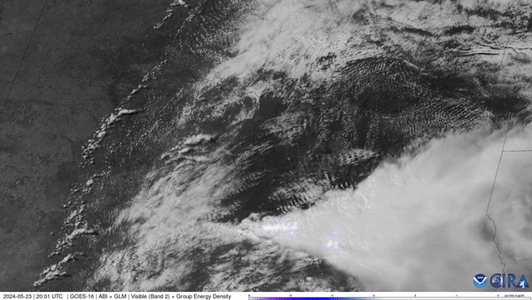
Satellite: GOES-16
Product: Visible (Band 2), GLM Group Energy Density
Instrument: ABI, Geostationary Lightning Mapper
Date: May 23, 2024 (20:00 UTC) - May 23, 2024 (22:54 UTC)
NOAA’s GOES East (GOES-16) satellite watched severe thunderstorms fire up along a dry line situated in west Texas and western Oklahoma on May 23, 2024.
For a week, the central U.S. has been under a constant barrage of potent, sometimes deadly storms. Tornadoes swept across six states, killing at least five people in Iowa, injuring dozens of others and inflicting widespread damage that is estimated in the tens of millions of dollars. On Wednesday, tornadoes hit parts of central Texas, destroying homes and triggering rescue operations.
The GOES East geostationary satellite, also known as GOES-16, keeps watch over most of North America, including the contiguous United States and Mexico, as well as Central and South America, the Caribbean, and the Atlantic Ocean to the west coast of Africa. The satellite's high-resolution imagery provides optimal viewing of severe weather events, including thunderstorms, tropical storms, and hurricanes.