
Hurricanes, tornadoes, and blizzards are well known for their destructive impact to life and property, but fog is a silent, often underestimated threat. Fog is a low-lying cloud made up of tiny water droplets suspended in the air near the Earth’s surface that can drastically reduce visibility, posing serious hazards for drivers, pilots, and mariners. Sea fog, which forms when warm, moist air moves over cooler water, can bring entire ports and airports to a standstill. Dense fog, where visibility drops to a quarter-mile or less, can trigger transportation shutdowns and cause ripple effects that result in millions of dollars in economic losses.
Unlike rain or snow, fog droplets are usually too small to be detected by radar. Weather stations and balloon-borne instruments called radiosondes can detect fog locally, but lack the coverage needed to track widespread or fast-changing events. That’s where satellites come in. NOAA’s Joint Polar Satellite System (JPSS) satellites (Suomi NPP, NOAA-20, and NOAA-21) carry advanced sensors that help forecasters detect, track, and predict hazardous conditions such as fog, dust, snow, smoke, and heavy precipitation that can reduce visibility across vast regions, including oceans and rugged terrain where ground-based observations are scarce.
Fog poses major risk for drivers
Each year, an average of 38,700 vehicle crashes occur in foggy conditions, according to the U.S. Department of Transportation. In 2024 alone, more than 600 people were killed and over 16,300 were injured in fog-related collisions. Most of these accidents occur during the winter, when changing weather conditions and sublimation from snowmelt—where snow directly transitions from a solid to water vapor—can increase the likelihood of fog formation. In October 2023, a dangerous super fog developed when smoke from marsh fires combined with fog near New Orleans, Louisiana. The thick fog reduced visibility to less than ten feet, which led to a mile-long pileup on Interstate 55 that resulted in multiple fatalities.
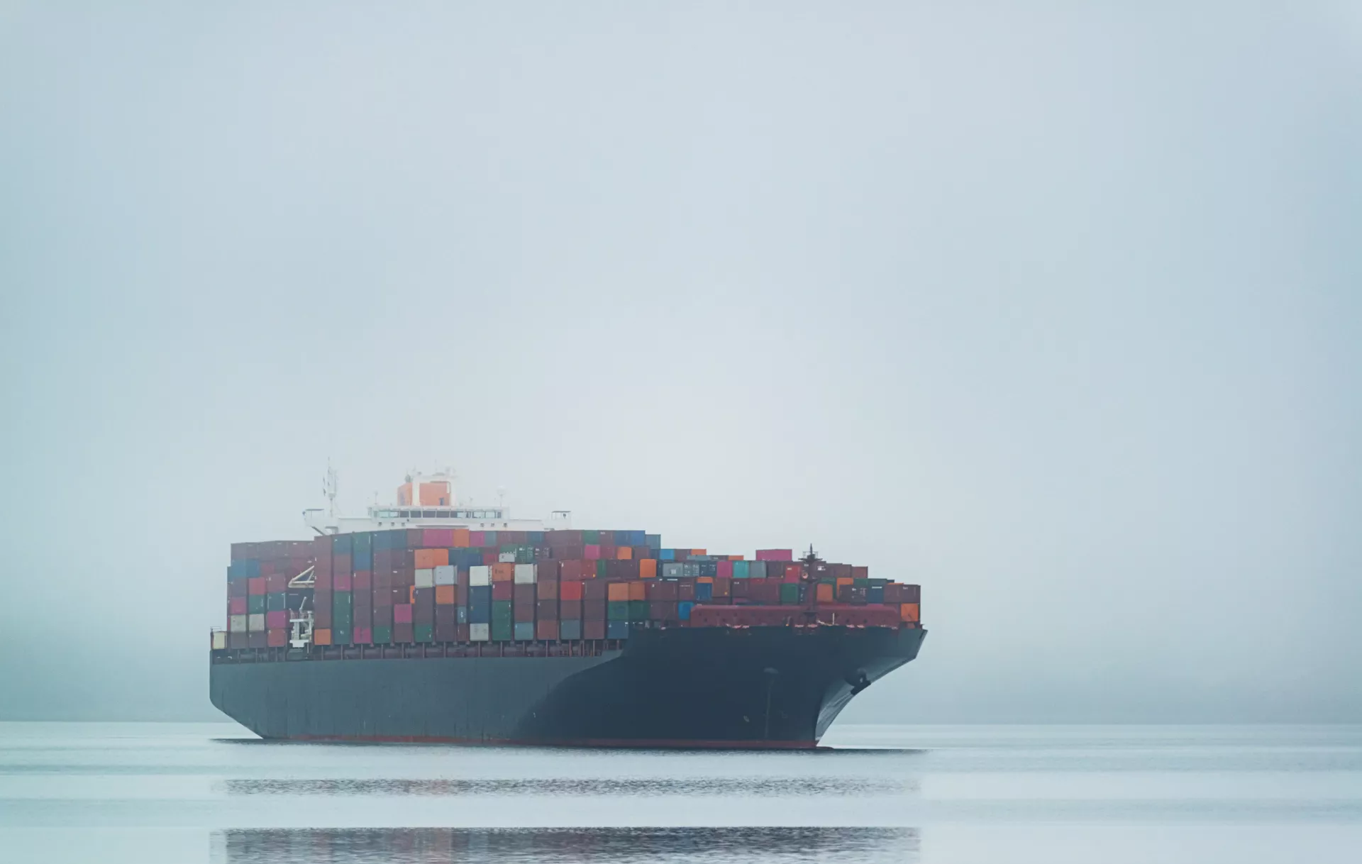
Fog can disrupt aviation and maritime operations
Fog isn’t just a highway hazard—it has been a contributing factor in major transportation disasters throughout history. One example was the 1977 Tenerife airport disaster, where two Boeing 747 passenger jets collided on the runway, becoming the deadliest plane crash in airline history. Additionally, fog is responsible for 70% of ship collisions at sea. Despite advances in modern radar and navigation systems, accidents involving small fishing boats are on the rise. These boats largely rely on traditional foghorns to navigate when visibility is low, an approach that may be insufficient in busy harbors.
One notable example occurred in February 2025, when unseasonably warm air over cooler Gulf waters created dense fog in Houston, Texas that disrupted shipping operations at Port Houston, the busiest port in the U.S., for 14 consecutive days. “Weather challenges can be great disruptors for maritime operations, and in February we were hit hard,” said Port Houston CEO Charlie Jenkins. Port Houston supports 200 facilities and contributes $906 billion annually to the national economy. That winter, fog and other weather delays caused a 29% drop in channel availability, compared to just 2.5% the year before.
NOAA satellites provide near real-time warnings
Fog detection and warning systems heavily rely on satellite observations, especially over oceans and in remote areas to see the full extent of the fog. The Visible Infrared Imaging Radiometer Suite (VIIRS) aboard the JPSS satellites, is a key instrument collecting daily global observations of Earth’s land, atmosphere, and oceans across 22 spectral bands in the visible and infrared wavelengths. The sensor’s broad capabilities support forecasters in detecting and monitoring low-visibility conditions, both day and night, caused by low clouds, fog, volcanic ash, dust, and smoke.
One particularly valuable tool for nighttime fog detection is the VIIRS Nighttime Microphysics RGB (Red-Green-Blue) product. It combines multiple infrared bands to generate an image that distinguishes fog and low clouds from other cloud types. This is done by analyzing the unique infrared signatures, or spectral fingerprints, of various cloud types and color-coding them for easier identification.
Other popular VIIRS products for detecting low clouds and fog include the VIIRS Day Snow/Fog RGB product and the VIIRS Snow/Cloud Discriminator. Both use a combination of VIIRS bands to help forecasters distinguish between low-level clouds and snow or ice over land which can often look alike in air photos and imagery. The VIIRS Snow/Cloud Discriminator works both day and night, using the unique VIIRS Day/Night Band to detect very faint nighttime light, such as moonlight reflecting off clouds. This is especially valuable in regions like Alaska, where long winter nights limit the use of daytime satellite observations.
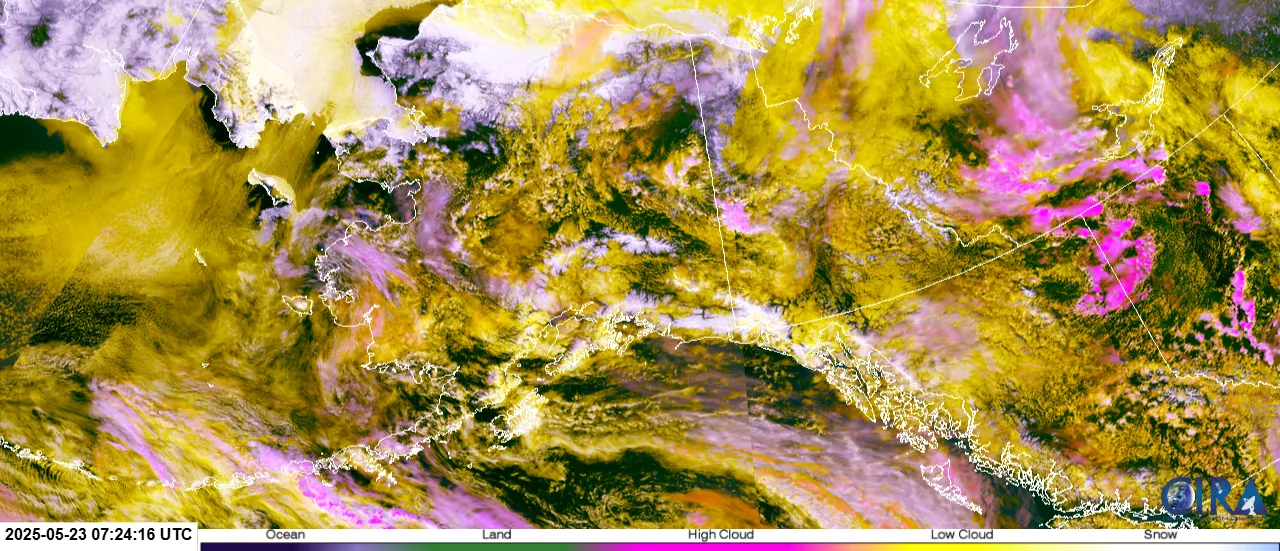
Widespread low-level clouds were detected on May 23, 2025, at 11:24 PM local time by the NOAA-20/S-NPP VIIRS Snow/Cloud Discriminator over Alaska and the surrounding waters, appearing as yellow making them easy to distinguish from the white snow and ice. Source: RAMMB/CIRA SLIDER.
These satellite capabilities are not just theoretical—they’re actively used in operational settings. Christopher L. Smith of the Cooperative Institute for Satellite Earth System Studies (CISESS) emphasizes the value of VIIRS and uses its products to train meteorologists in fog detection and analysis. “My role as a satellite liaison,” Smith explains, “is to infuse satellite products, both [geostationary] and LEO, into operations at [NOAA] Weather and Ocean Prediction Centers.”
As part of this role, Smith trains forecasters to use satellite data effectively and gathers feedback to share with product developers, helping ensure the tools are practical for operational use. “The VIIRS Nighttime Microphysics RGB with its high spatial resolution really lets us see the detail of the fog,” he says. “The Weather Prediction Center uses low Earth orbit (LEO) satellite data for a variety of forecasting purposes, mainly convection and heavy rainfall, and for drawing boundaries on the surface analyses to see phenomena like fog.”
NOAA forecasters often use data from both LEO and geostationary satellites together to enhance coverage and offer a more complete view of atmospheric conditions. Geostationary satellites, like those in NOAA’s GOES series, provide frequent updates—as often as every 5 minutes over the contiguous U.S.—which are essential for monitoring rapidly evolving weather conditions. However, their fixed position over the equator can cause features at higher-latitudes, like Alaska, to appear distorted and displaced, making it more difficult to detect small-scale phenomena like low clouds and fog in these areas.
Polar-orbiting satellites like the JPSS series, can fill these gaps though. VIIRS passes over Earth’s poles 14 times a day, providing direct overhead views that better capture features at high latitudes that geostationary sensors might miss. Such observations are crucial given the already high and growing volume of ship traffic in the Arctic region, which relies on accurate fog detection for safety and operational planning.
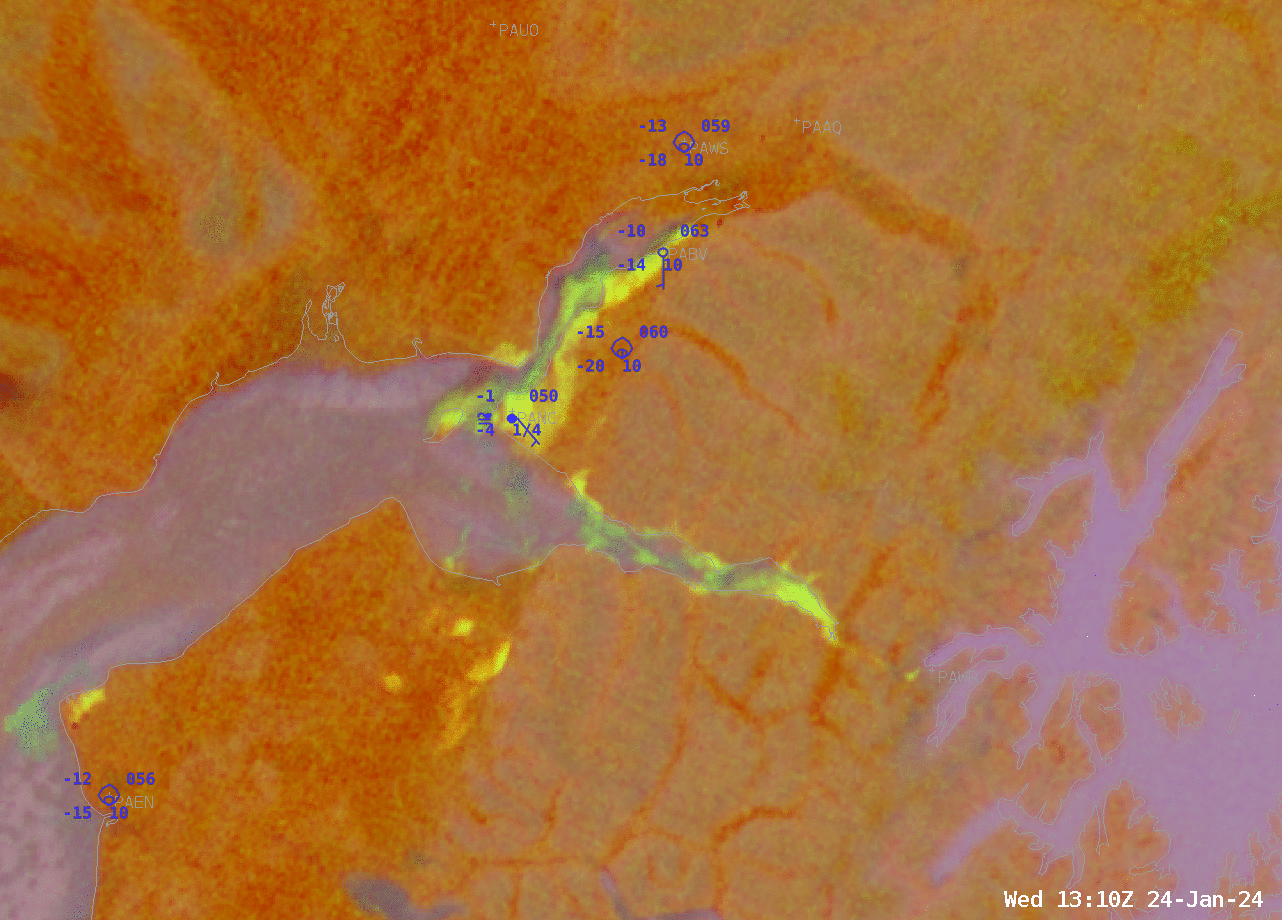
This animation compares imagery over Alaska on January 24, 2024, from the JPSS VIIRS Nighttime Microphysics RGB product (detailed imagery) and the geostationary GOES-West ABI Nighttime Microphysics RGB product (pixelated imagery). While geostationary satellites provide more frequent updates than polar orbiting LEO satellites, their coarse resolution limits their ability to resolve localized fog. In contrast, the higher resolution VIIRS imagery clearly captures small-scale fog development (yellow shading) near Anchorage, offering critical detail for forecasters monitoring visibility hazards in the region. Credit: Bill Line, NESDIS/STAR.
Instruments onboard NOAA’s JPSS satellites provide essential information that improve weather forecasts and help protect lives, property, and the national economy. Fog detection is just one example of how these observations support real-world decision-making. From aviation and highway safety to port operations and shipping routes, having timely and reliable information on low-visibility conditions is critical.
Looking ahead, JPSS-3 and JPSS-4—the next satellites in the JPSS constellation that are currently in development—will extend critical LEO observations well into the 2030s.