
Covering 70 percent of the earth surface, the ocean plays a critical role in shaping our weather patterns and climate, as well as providing vital food resources and global transportation. The global ocean data from Joint Polar Satellite System (JPSS) satellites aid not only in critical weather forecasting, but in the monitoring of oceanic variables and changes. NOAA uses these data to help protect human life, property and endangered aquatic species.
Monitoring Harmful Algal Blooms
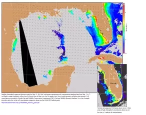
Gulf of Mexico Harmful Algal Bloom Bulletin, May 11, 2015. CREDIT: NOAA
The Visible Infrared Imaging Radiometer Suite (VIIRS) instrument on board JPSS satellites can identify large fields of microscopic algae, which bloom in the ocean surface layer.
When naturally-occurring microscopic algae rapidly develop under certain temperature and seasonal conditions, the resulting algal blooms can grow to vast proportions.
Some of these blooms can contain toxins that are harmful to the marine environment. When this occurs, these blooms are called Harmful Algal Blooms (HAB). HABs are known to have devastating impacts on both aquatic and coastal ecosystems.
Significant fish, shellfish, marine mammal, and bird morbidity can occur and illness in people can result from breathing toxic air from the blooms or from eating contaminated fish and shellfish. As a result, coastal HAB events cost an estimated at $82 million a year, impacting commercial and recreational fishing, tourism and valued habitats. These impacts affect local economies and the livelihood of coastal residents.
Using JPSS satellite data, NOAA’s National Ocean Service (NOS) has created the NOAA HAB Operational Forecast System to provide specific tools and information on localized HAB events. The program focuses on the Gulf of Mexico, but NOS additionally monitors blooms in the Great Lakes, Northeast, Pacific Coast, Mid-Atlantic/Southeast, and Caribbean/Pacific Islands.
Helping to Protect Endangered Species

Loggerhead Turtle escaping a net equipped with turtle excluder device. CREDIT: NOAA
JPSS VIIRS data also feeds NOAA’s operational global Sea Surface Temperature (SST) data product, which blends data from all active Polar-orbiting Operational Environmental Satellites and Geostationary Operational Environmental Satellites.
Sea surface temperature data are essential to understanding the state of the Earth’s weather and climate system, and allow for the monitoring of global marine ecosystems and species. SST data compiled over time reveal surface currents which allows for estimations of the ocean-to- atmosphere exchange of heat, momentum and gases, a critical parameter in both oceanic and atmospheric forecasting. Moreover, this compiled data can be used to monitor anomalies or trends in SST which helps scientists to characterize threats such as coral bleaching or track the habitat of species, such as sea turtles.
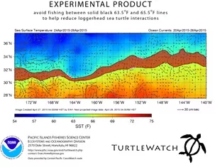
The TurtleWatch product is a composite image of remotely-sensed sea surface temperature (SST) data and derived ocean current vectors. The mapped temperature values represent averages of SST information for the most recently available 3-day period. CREDIT: Pacific Islands Fisheries Science Center, NOAA
Endangered loggerhead sea turtles have been found to prefer temperate waters from 63.5 – 65.5°F. SST information is used to help reduce inadvertent interactions between Hawaii-based longline fishing vessels and the endangered loggerhead turtles as part of NOAA’s National Marine Fisheries Service (NMFS) TurtleWatch program. This program provides up-to-date information about the location of this narrow band of loggerhead sea turtle habitat in the Pacific Ocean north of the Hawaiian Islands.
The TurtleWatch map displays SST and ocean current conditions and the predicted location of waters preferred by the turtles to help fishermen avoid potentially deadly interactions. NMFS expects these TurtleWatch maps to help reduce the accidental capture of loggerheads by longline fishing vessels pursuing swordfish or other species. Fishermen operate under strict limits on fishing interactions with the turtles, so this helps them as well.
Identifying Safe Passages
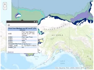
Sea Ice Map. CREDIT: NOAA
The NOAA National Weather Service (NWS) Weather Forecast Offices (WFOs) in Alaska use VIIRS data to routinely monitor potentially threatening conditions around the arctic ice pack.
With one of the most productive and sustainable fisheries in the world, the Alaskan marine ecosystem harvests almost six billion pounds of seafood per year. Alaskan residents hold 7,000 commercial fishing permits and nearly 12,000 full-year crew member licenses, meaning many Alaskan lives and livelihoods are dependent upon accurate forecasting of oceanic conditions. With estimated total earnings of $681 million from the fishing industry, monitoring and supporting navigation around sea ice is critical to protecting life and property around the vast Alaskan coastline.
JPSS data are critical to the NWS ice operations, which uses imagery to monitor ice extent as well as potential hazards throughout the region. Forecasters produce graphic analyses of SST, sea ice and five-day sea ice forecasts year-round as a public service to public and private maritime operations. This ice forecast assists fishing and commercial vessels in determining the safest and most efficient route.
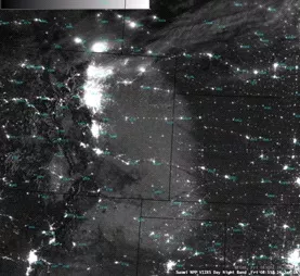
Suomi NPP VIIRS Day/Night Band image shows a broad area of snow cover over parts of the High Plains and Foothills regions of the US. CREDIT: CIMSS
JPSS satellite data have also become invaluable to NWS operations because in the arctic winter, it provides Day/Night Band imagery at night using the light of the moon. This type of high- resolution satellite imagery is not available from any other satellite. Imagery from the Day/Night Band on VIIRS instrument enables Alaska WFOs to clearly see high-resolution features throughout the year without sunlight.
Monitoring Global Coral Reef Health
The Coral Reef Watch(CRW) program, uses JPSS satellite and in-situ data for near-real-time and long term monitoring of environmental conditions of coral reef ecosystems. Since 2000, CRW has produced satellite-based products, maps, and alerts that identify high SSTs on coral reefs – a key cause of coral bleaching. When bleaching conditions occur that endanger coral health, these tools can be used to support bleaching response plans.
With 75 percent of the world's coral reefs at risk from local and global stresses and 10 percent already damaged beyond repair, JPSS data are critical for researchers to understand and better manage the complex interactions leading to coral bleaching.
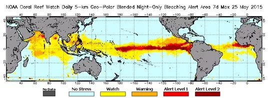
Daily 5-km Bleaching Alert Area (7-day max) product for May 25, 2015 CREDIT: NOAA Coral Reef Watch.
JPSS data products are an important asset to monitoring and protecting our oceans’ ecosystem and global economy by providing timely and high quality data for decision support through significant technological and scientific advances.
JPSS’ work to identify HABs and coral bleaching events, assisting in protecting endangered species and monitoring threats around Alaska are just the tip of the iceberg to what JPSS data can help accomplish. JPSS also delivers key observations for the Nation's essential products and services, including forecasting severe weather like hurricanes, tornadoes, and blizzards days in advance, and assessing environmental hazards such as, droughts, forest fires, poor air quality and harmful coastal waters, helping to secure a more “Weather-Ready Nation.”
JPSS enables forecasters and scientists to monitor and predict weather patterns with greater accuracy and to study long-term climate trends by extending the more than 30-year satellite data record. NOAA is responsible for managing the JPSS program science, operations and developing parts of the ground segment. NASA is responsible for developing and building the JPSS instruments, spacecraft and ground system.