
HOW NOAA’S POLAR-ORBITING SATELLITE DATA ARE USED TO HELP REEF CONSERVATION AROUND THE WORLD
The NOAA/NASA Suomi NPP satellite’s Visible Infrared Imaging Radiometer Suite (VIIRS) instrument helps improve NOAA’s ability to track coral reef health.
The National Environmental Satellite Data Information Service’s (NESDIS) Coral Reef Watch (CRW) effort, with support from the NOAA Coral Reef Conservation Program, produces information to help protect coral reefs. CRW uses remote sensing and in-situ tools for near-real-time and long term monitoring, modeling and reporting of physical environmental conditions of coral reef ecosystems.
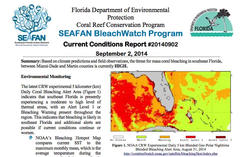
CRW is using a blend of polar-orbing satellite data from NOAA POES, VIIRS data and NOAA GOES satellite data for Sea Surface Temperature (SST) analysis. This provides a 100-fold improvement in spatial resolution over earlier products, giving scientists crucial information to track reef health around the globe. For the past 15 years, CRW has provided coral reef managers, scientists, and the public with satellite-based products, maps, and alerts when high SST are present, a key cause of coral bleaching. CRW recently released its Coral Bleaching Thermal Stress Outlook which forecasts the potential for coral bleaching up to four months in the future.
The new products were made available to users in the summer of 2014, just in time to document record-breaking coral bleaching on the Main and Northwestern Hawaiian Islands, Commonwealth of the Northern Marianas Islands, and significant bleaching in Guam and Florida and were immediately picked up and used by regional resource management agencies.
These new blended SST products help reduce missing data caused by cloud coverage over the oceans. This is particularly vital in areas such as the “Coral Triangle,” which consists of the tropical marine waters of Indonesia, Malaysia, Papua New Guinea, Philippines, Solomon Islands and Timor-Leste that had six months of persistent cloud cover in 2010. The VIIRS instrument provides data for the ocean, land, aerosol, and cloud research and offers improved spatial resolution, which is a substantial improvement for coastal and estuarine areas in particular.
Coral reefs are often called the “rainforests of the sea,” as they are some of the most biodiverse and productive ecosystems on earth, occupying only 0.1 percent of the ocean, yet home to a quarter of all marine species. Crustaceans, reptiles, seaweeds, bacteria, fungi and over 4000 species of fish call coral reefs home. Coral reefs are estimated at an annual global economic value of $375 billion, and provide food and resources for over 500 million people in 94 countries and territoriesi.
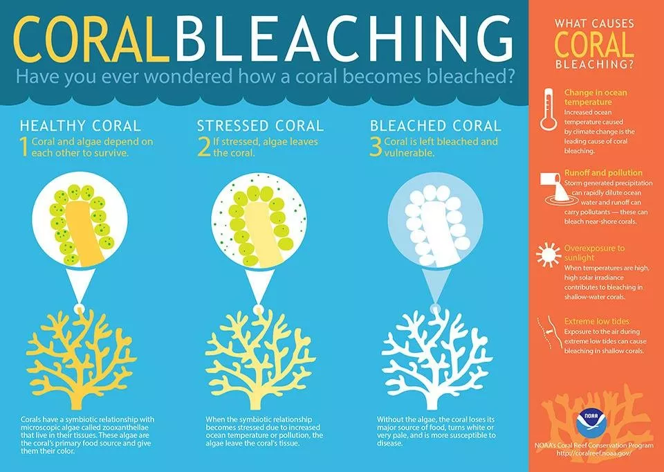
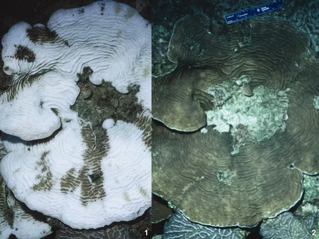
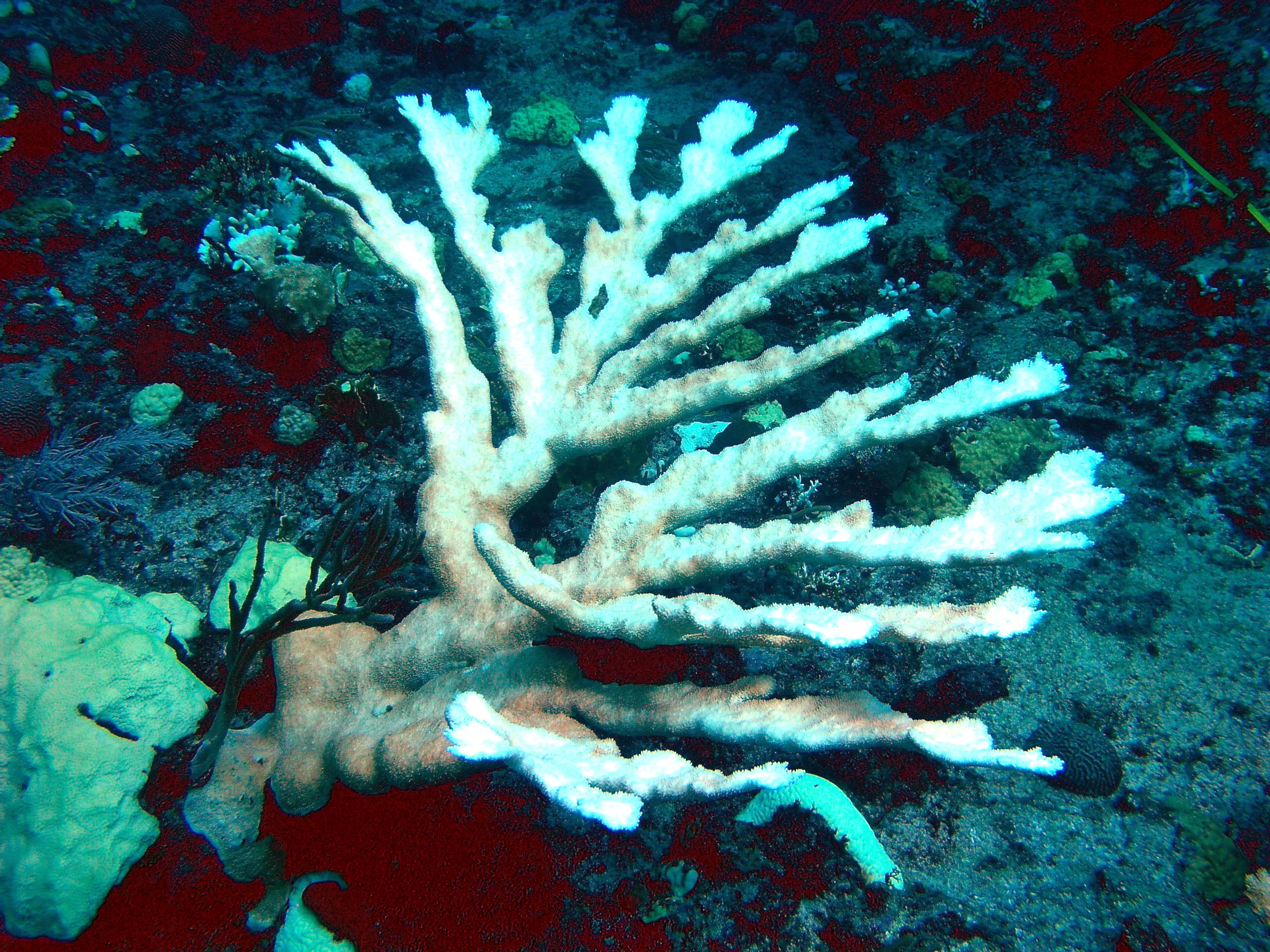
Coral bleaching occurs when corals are stressed by changes in conditions such as temperature, light, or nutrients, and they expel the symbiotic algae living in their tissues, causing them to turn completely white. As temperatures riseii, mass bleaching and infectious disease outbreaks are a potential consequence that could become more frequent. In 2005, the U.S. lost half of its coral reefs in the Caribbean in one year due to a massive bleaching eventiii.
Coral reefs are also affected directly by changes in carbon dioxide (CO2). When CO2 is absorbed into the ocean from the atmosphere, it alters seawater chemistry through decreases in pH (ocean acidification). This slows the rate at which corals and other reef-building organisms can build their skeletons and shells.
With 75 percent of the world’s coral reefs at risk from local and global stresses, and 10 percent already damaged beyond repair, JPSS data are critical for researchers to understand and better manage the complex interactions leading to coral bleachingiv. When bleaching conditions occur, these tools can be used to trigger bleaching response plans and support appropriate management decisions.
JPSS represents significant technological and scientific advances in environmental monitoring and will help advance weather, climate, environmental and oceanographic forecasting and monitoring. JPSS delivers key observations for the Nation's essential products and services, including forecasting severe weather like hurricanes, tornadoes and blizzards days in advance, and assessing environmental hazards such as sea ice, droughts, forest fires, floods, poor air quality and harmful algal blooms in coastal waters, helping to secure a more “Weather-Ready Nation.”
JPSS enables scientists and forecasters to monitor and predict weather patterns with greater accuracy and to study long-term climate trends by extending the more than 30-year satellite data record. NOAA is responsible for managing and operating the JPSS program, while NASA is responsible for developing and building the JPSS satellite and ground system.