

Alaskans are no stranger to dangerous jobs. Commercial fishing is continually ranked as the most dangerous job in America and commercial pilots in Alaska are five times more likely to have an accident as compared to the national average. Data from NOAA satellites, such as the NOAA/NASA Suomi NPP, have assisted in countless rescues of distressed pilots and sea vessels.
NOAA’s National Weather Service (NWS) Weather Forecast Offices (WFOs) in Alaska use the data from the Visible Infrared Imaging Radiometer Suite (VIIRS) instrument on Suomi NPP to produce graphic analyses of sea surface temperatures, sea ice and five-day sea ice forecasts year round. VIIRS collects global observations of land, atmosphere, and oceans.
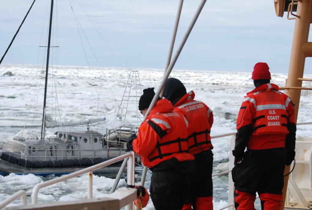
The ice forecast is vital for sea vessels’ safety. NOAA’s satellite observations proved critical in early July when a 35-foot aluminum hull sailing vessel traveling the Northwest Passage on its way to eastern Canada became trapped in ice 25 nautical miles northeast of Barrow, Alaska. The U.S. Coast Guard (USCG) contacted the NWS Ice Desk requesting assistance.
WFO Anchorage Sea Ice Program members Becki Legatt and Mary-Beth Schreck reviewed the latest sea ice conditions, coordinated with the WFO in Fairbanks, Alaska, and were able to share with the Coast Guard sea ice analyses, forecasts and imagery to assist them. Legatt and Schreck were able to ascertain that the vessel was surrounded by sea ice in an area of 70-90 percent ice cover with strong winds which were shifting the ice. Using NOAA satellite data, they recommended advising the vessel to head toward the west facing coast of Barrow.
After the incident, Rear Adm. Dan Abel, commander, 17th Coast Guard District said that the WFO Anchorage sea ice forecasters provided “phenomenal weather products” that proved key to USCG’s decision to tow the vessel to a position off the west coast of Barrow until it could safely navigate to Canada.
The Suomi NPP satellite, launched in 2011, is a bridge between legacy NOAA environmental satellites and the next-generation Joint Polar Satellite System (JPSS). JPSS polar-orbiting satellites (which mean they circle the Earth from pole to pole) will improve forecasting for hurricanes, droughts, floods, snowstorms, and other weather disasters. Suomi NPP is the first flight of the instruments that will be on satellites in the JPSS constellation. NOAA’s NWS is one of the primary users of data and operational measurements from Suomi NPP.
NOAA’s polar-orbiting satellites are critical for weather forecasts beyond 48 hours enabling the timeliness and accuracy of forecasts three to seven days in advance of a severe weather event. These early warning capabilities enable emergency managers to make timely decisions to protect American lives and property. JPSS polar satellites are also critical for a variety of “nowcasting” capabilities including imagery in the Polar Regions where geostationary satellites (satellites which circle above the Equator) are less effective and to enable monitoring of storms, fog, sea ice volcanic ash and other dangerous weather and environmental conditions. JPSS satellites will continue to deliver new satellite data, imagery and productions to increase the reliability of weather forecasting capabilities for severe weather events and phenomena to secure a more “Weather-Ready Nation”.
Data from Suomi NPP is also used by The U.S. National Ice Center (NIC). The NIC is a multi-agency operational center operated by the United States Navy, NOAA, and the USCG to provide high quality, timely, accurate, and relevant snow and ice products and services.