
Wildfire season in the Southwest and High Plains arrived early this year, fueled by gusty winds, low humidity, and dry conditions.
The most recent data from the U.S. Drought Monitor from April 21, 2022, shows that the region, particularly New Mexico, has been affected by significant drought conditions. New Mexico has been dealing with more than 20 blazes, including the Calf Canyon Fire, Cooks Peak Fire, and Mitchell Fire. In Arizona, the Crooks Fire has burned south of Prescott since last Monday, triggering numerous evacuation orders in the area. The fire is burning thick, dry, dead vegetation in very rugged terrain, where erratic winds and fire behavior is making conditions hazardous for firefighters.
Imagery from the GOES East satellite showed that the Calf Canyon Fire in New Mexico produced a pyrocumulonimbus cloud (also known as pyroCb) on April 22. This large fire burned hot, which caused air and moisture to rise, along with smoke and ash. When this combination reaches the upper atmosphere, it often cools and condenses to form pyroCb clouds or “fire clouds” over the blaze. Some of the moisture is already present in the atmosphere, while some of it also evaporates from burning plants fueling the fire below.
PyroCb clouds are smoke-infused thunderstorms. They can produce lightning, which can set off even more fires. PyroCb clouds also generate stronger winds, which fan the fire, making it hotter and helping it spread. In some cases, the air may rise so fast that it creates a tornado. Strong winds contributed to the rapid intensification and spread of the Calf Canyon Fire—the peak wind gust at nearby Las Vegas was 74 mph.
Parts of the High Plains have experienced windy, dry weather as well, which caused dust storms and fast-spreading wildfires. The fast-spreading Road 702 Fire in southwestern Nebraska that claimed the life of a former fire chief started in Kansas and raced northward through several counties. So far, it has consumed roughly 41,450 acres. By Thursday morning, it was 88 percent contained.
According to the National Interagency Fire Center, there were 11 large active fires burning across almost 223,800 acres across six states. Since the start of 2022, at least 21,181 wildfires have burned more than a million acres in the United States, well above the 10-year average through April. With so many fires burning well before the normal May or June start of the wildfire season, local officials say there is a much higher risk for the rest of the season.
The VIIRS instrument on the Joint Polar Satellite System’s NOAA-20 and Suomi NPP satellites play an important role in detecting and tracking wildfires, especially in remote regions. At 375 meters per pixel, the high spatial resolution from VIIRS allows the instrument to detect both large and smaller-lower temperature fires. VIIRS also provides nighttime fire detection capabilities through its Day-Night Band, which can measure low-intensity visible light emitted by small and fledgling fires.
The High-Resolution Rapid Refresh (HRRR)-Smoke model produces forecasts of both surface and high-altitude smoke up to 48 hours into the future. The product, which is used by fire crews, first responders and air traffic controllers, measures the amount of heat released by a fire in megawatts. It also incorporates observations of wind speed, rain, and atmospheric temperatures, and combines that with vegetation maps to incorporate what’s burning. All of these measurements are mapped to a three-dimensional grid that extends nearly 12.5 miles into the atmosphere, producing detailed updates of the amount of smoke produced, the plume height and the direction the smoke is expected to move.
Timely satellite imagery is critical, potentially life-saving information in a dynamic fire environment. In the past, incident meteorologists had a single low-resolution image that updated every 15 minutes—typically the image was already 20 minutes old when it arrived at the forecaster. Now, GOES-16 and GOES-17 frequently detect fires before they are spotted on the ground – as early as 10 to 15 minutes before emergency notifications to 911.
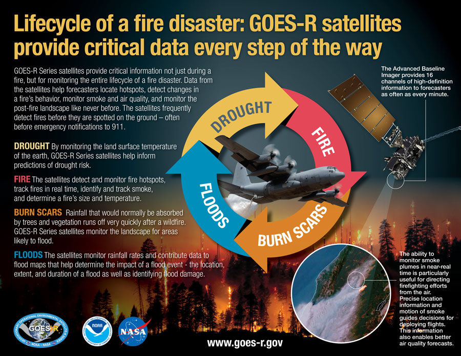
The benefits provided by the latest generation of NOAA satellites aren’t just seen during a fire but are important in monitoring the entire life cycle of a fire disaster. Data from the satellites are helping forecasters monitor drought conditions, locate hot spots, detect changes in a fire’s behavior, predict a fire’s motion, monitor smoke and air quality, and monitor the post-fire landscape like never before.