
On Jan. 3, 2019, a 24-foot pleasure craft with two people onboard capsized and sank approximately five miles southwest of Huntington Beach, Calif. Luckily, an Emergency Position Indicating Radio Beacon (EPIRB) from the boat was detected by a NOAA satellite, which enabled the Coast Guard, together with the Huntington Beach Fire Department, to rescue the two individuals from the water and transport them to shore. The Orange County Sheriff’s Department then brought them to a local hospital for treatment.
These two boaters are among an estimated 421 people rescued within the United States and its surrounding waters with the help of NOAA satellites last year. Of those rescues, 306 people were rescued in 96 incidents at sea, 38 people were rescued from 20 aviation incidents, and 77 people were rescued in 61 incidents using personal locator beacons (PLBs) on land.
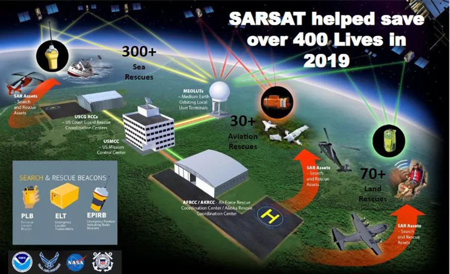
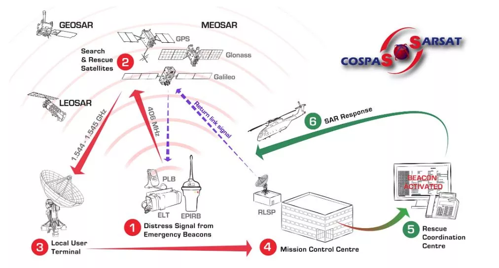
NOAA satellites are part of a network of U.S. and international spacecraft that quickly detect and locate distress signals from emergency beacons aboard aircraft, boats, and from handheld PLBs. This program, called COSPAS-SARSAT includes a total of 41 nations and two independent SAR organizations. COSPAS stands for COsmicheskaya Sisteyama Poiska Avariynich Sudov, which is a Russian acronym for Space System for Search of Distress Vessels, while NOAA’s SARSAT stands for Search and Rescue Satellite-Aided Tracking.
Various NOAA satellites, including the GOES-R series, carry SARSAT transponders that detect distress signals from emergency beacons and relay them to the closest ground stations, called Local User Terminals. From there, the information is sent to the SARSAT Mission Control Center at NOAA’s Satellite Operations Facility in Suitland, Maryland before quickly being routed to Rescue Coordination Centers, operated either by the U.S. Air Force for land rescues, or the U.S. Coast Guard for water rescues.
"NOAA satellites play a vital role in the U.S. SARSAT Program, which assists in saving hundreds of lives each year,” said Lieutenant Aaron D. Colohan, SARSAT Operations Support Officer from NOAA Corps. “NOAA, USCG, USAF, and NASA work together to maintain and operate the SARSAT System, which has alerted rescue forces to distresses at sea and land. The SARSAT system is an integral piece of the search and rescue mission in this country and is an essential part of the International COSPAS-SARSAT System which detects distress signals around the globe."
Since the program’s inception in 1982, COSPAS-SARSAT has been credited with supporting more than 48,000 rescues worldwide, including nearly 9,100 people in the United States and its surrounding waters.
Beacon owners are required to register their devices online with NOAA. The registration information often helps provide better and faster assistance to people in distress, and can guard against false alarms. It may also provide information about the location of the emergency, what type of help may be needed, and ways to contact the owner. At the end of 2019, NOAA’s database contained more than 600,000 registrations.
For more information about the SARSAT rescues that occurred in 2019, please visit the NOAA website.
To see a map of where SARSAT rescues have taken place, please visit NOAA’s SARSAT website.