
January 27, 2021

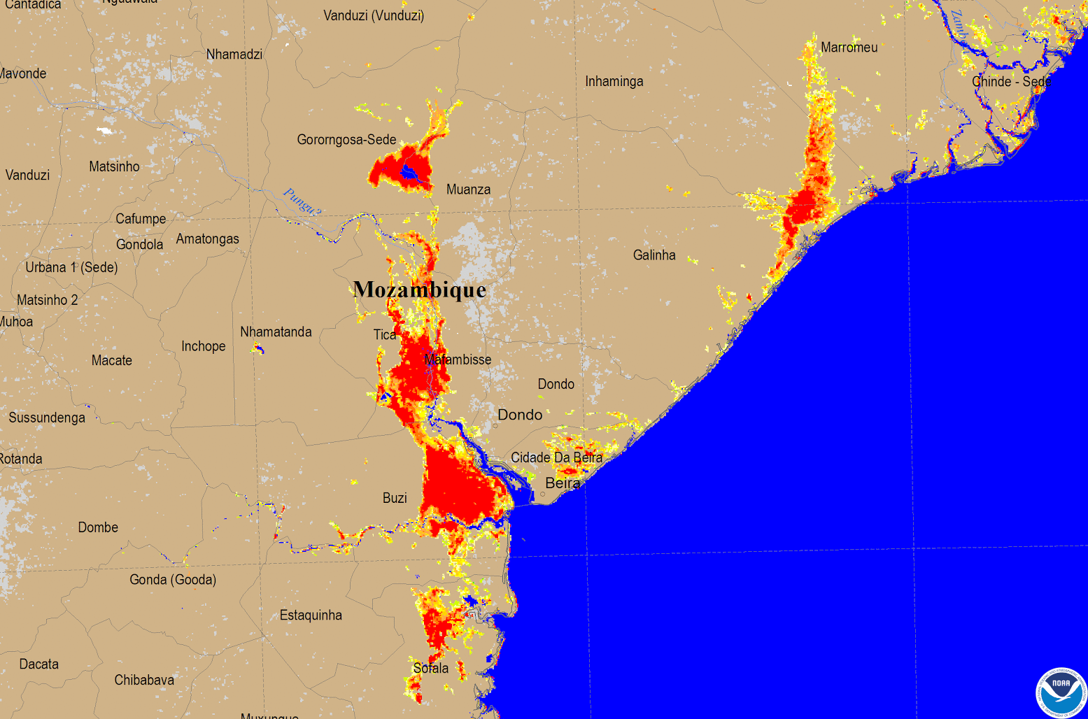
The image above, created from VIIRS data from the Suomi-NPP and NOAA-20 satellites, shows the extent of flooding in central Mozambique after Cyclone Eloise struck the coastal city of Beira.
Eloise came ashore on Jan. 23, 2021, with sustained winds of nearly 90 mph, making it the equivalent of a Category-1 hurricane on the Saffir-Simpson Hurricane scale. More than a foot of rain fell over 24 hours in Beira, according to Mozambique’s National Institute of Meteorology. This NOAA LEO Flood product imagery, which is scheduled to be operational later this year, is from Jan. 26 and shows the extent of the flooding in locations around Mozambique caused by a combination of rainfall from Eloise and from previous heavy rainfall in the region. The yellow shading represents minor to moderate flooding or ground moisture and the redder shading represents more significant flooding/ground moisture in locations immediately to the north and west of Beira.
Satellites are a crucial technology for monitoring and responding to natural disasters like flooding. More specifically, the VIIRS instrument on the JPSS satellites provides complete global coverage on a daily basis and is a critical resource for tracking natural and human-caused environmental and weather-related changes over time. With this information, relief agencies can see where the most flood-affected populations are located, —including areas where roadways may be washed out—when they determine where and how to send relief supplies.
NOAA’S JPSS satellites circle the globe 14 times daily and capture a complete daytime view of our planet once every 24 hours. The VIIRS instrument, part of a suite of instruments and sensors aboard NOAA’s JPSS satellites, can scan the entire Earth twice per day at a 375-meter to 750-meter resolution. Multiple visible and infrared channels allow it to detect a multitude of environmental information from Earth orbit, including dust, smoke, wildfires, nighttime lights, flooding, and more. Images taken by the VIIRS sensor during each orbit are then merged together to create composites of larger regions, like the imagery used here.