
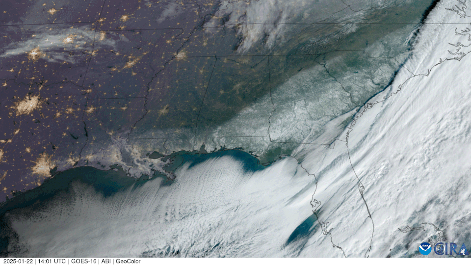
As the sun rose over the southern U.S. on January 22, 2025, NOAA’s GOES East (GOES-16) satellite could see a landscape blanketed in snow.
In January 2025, an extraordinary winter storm brought historic snowfall and bone-chilling temperatures to parts of the Deep South, astonishing residents and keeping meteorologists busy around the clock. Cities like Atlanta; Houston; New Orleans; Gulf Shores, Alabama; Milton, Florida; Myrtle Beach, South Carolina; and Pensacola, Florida experienced rare snow—some for the first time in decades, while others shattered decades-old records. This rare winter storm highlights both the impacts extreme weather can have on our lives and the vital role NOAA satellites play in monitoring and forecasting these events.
How NOAA Satellites Supported Forecasting
NOAA’s mission to understand and predict our changing environment is supported by its fleet of advanced satellites. During this historic storm, NOAA’s GOES and JPSS satellites provided critical data for tracking the potent winter system that dropped unprecedented snow in some areas and brought record cold to parts of the South.
GOES East: Near Real-Time Storm Monitoring
The GOES East satellite captured near real-time imagery of an Arctic air mass plunging into the Deep South, colliding with warm Gulf moisture to create ideal conditions for snow. Its advanced sensors allowed meteorologists to visualize cloud cover, track the storm’s development, and assess precipitation potential.
JPSS Satellites: In-Depth Atmospheric Analysis
Complementing GOES East, the JPSS satellites provided detailed data about the atmosphere, including temperature profiles, humidity, and cloud properties. These granular insights were essential for helping accurately predict the extreme cold and snowfall in regions unaccustomed to such weather events.
Preliminary Snowfall Reports
- Atlanta: Received 3.2 inches of snow in January 2025, surpassing its annual average of 2.2 inches.
- Houston: Houston Hobby Airport recorded 3 inches of snow, a rare occurrence for the city.
- New Orleans: Louis Armstrong New Orleans International Airport recorded 8 inches of snow.
- Gulf Shores, Alabama: Received 8.8 inches of snow.
- Milton, Florida: Recorded 9–10 inches of snow, potentially surpassing a Florida state record.
- Myrtle Beach, South Carolina: Received around 4–5 inches of snow, with 6 inches reported in Conway, South Carolina.
- Pensacola, Florida: Pensacola International Airport saw 8.9 inches of snow, a significant amount considering the city rarely has measurable snowfall.
The Importance of NOAA Satellites
This winter storm highlights the critical role NOAA satellites play in forecasting extreme weather events. GOES East’s near real-time imagery and JPSS’s detailed atmospheric data enabled forecasters to issue more accurate and timely warnings, helping communities prepare and mitigate potential disruptions.
Looking Ahead
When extreme weather strikes the U.S., NOAA’s satellite technology remains essential for understanding and responding to these high-impact events. From tracking Arctic outbreaks to monitoring tropical storms, NOAA satellites provide forecasters with the tools needed to protect lives, property, and the economy. These timely insights also empower individuals and communities to better prepare for severe weather, reducing risks and ensuring safety during extreme events.