
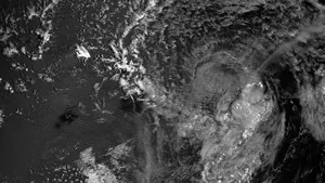
A powerful sensor onboard the Suomi NPP satellite played a critical role in locating the position of Tropical Storm Flossie during the nighttime hours on Monday, revealing it shifted more to the north, sparing the big island of Hawaii from a direct hit, but bringing the islands of Oahu, Molokai and Maui into a tropical storm warning area.
The sensor, called the Visible Infrared Imaging Radiometer Suite, or VIIRS, is a new instrument flying on Suomi NPP, America’s newest weather satellite. VIIRS is able to scan the land, oceans and atmosphere to more accurately capture data – even at night, using a "day-night band" channel.
"During the night, it's very difficult to use satellite infrared imagery to detect low-level circulation often associated with developing, or weakening, tropical cyclones," said Mitch Goldberg, program scientist for NOAA’s Joint Polar Satellite Program (JPSS). "But with Suomi NPP, the VIIRS day-night-band provides visible imagery at night, which now allows forecasters to more easily detect these circulation centers. So in this case the day-night band relocated Flossie, resulting in a different, more accurate forecast for the Hawaiian region."
NOAA forecasters in Hawaii happily embraced the VIIRS data.
"We were fortunate to have VIIRS day-night-band imagery Monday, which gave us a nice look at Tropical Storm Flossie," said Tom Evans, acting director of NOAA’s Central Pacific Hurricane Center. "With the VIIRS imagery, we were able to locate the center providing forecasters the confidence they needed to alter the center's location and the forecast track. Without the VIIRS imagery, we would have basically been guessing on Tropical Storm Flossie's center."
NOAA's JPSS is the nation’s next generation polar-orbiting operational environmental satellite system. JPSS represents significant technological and scientific advances for more accurate weather forecasting to secure a more 'weather ready nation' -- thus saving more lives and property, while promoting economic prosperity. JPSS provides continuity of critical Earth and environmental observations of our vast atmosphere, oceans, land, and cryosphere. NOAA, working in partnership with NASA on JPSS, ensures an unbroken series of global data for monitoring and forecasting environmental phenomena and understanding our Earth.
Suomi NPP is a NOAA-NASA partnership, and is the first of three next-generation JPSS satellites. JPSS remains on budget and on target to begin launching the JPSS-1 spacecraft in 2017.
NOAA’s mission is to understand and predict changes in the Earth's environment, from the depths of the ocean to the surface of the sun, and to conserve and manage our coastal and marine resources. Join us on Facebook, Twitter and our other social media channels.
NOAA’s mission is to understand and predict changes in the Earth's environment, from the depths of the ocean to the surface of the sun, and to conserve and manage our coastal and marine resources. Join us on Facebook, Twitter and our other social media channels.