
The ability to use satellites to locate a storm that could evolve into a severe storm, or hurricane, will likely become more accurate for this year's Atlantic hurricane season beginning June 1. By then, the National Oceanic and Atmospheric Administration's (NOAA) weather forecasters will be able to further improve the use of sensors aboard the NASA-NOAA Suomi National Polar-orbiting Partnership satellite known as Suomi NPP.
U.S. polar environmental satellites such as Suomi NPP provide complete global coverage twice daily, while NOAA’s geostationary operational environmental satellites offer imagery over a fixed area.
To improve the ability to better find and track hurricanes, NOAA scientists are finding ways to incorporate data from Suomi NPP's Visible Infrared Imaging Radiometer Suite (VIIRS), sensor that allows observations of Earth's atmosphere and surface during nighttime hours and offers enhanced capability to see through clouds. VIIRS provides many advances over previous operational imagers and advances compared to its research predecessor, the Moderate Resolution Imaging Spectroradiometers currently operating on NASA's Aqua and Terra satellites. It is these advances in polar imagery that will give forecasters a new tool to improve their predictions.
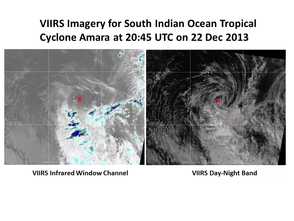
VIIRS Day-Night Band Sees Through Night
The information to track storms comes from satellite surface stations, weather balloons, radar and aircraft. Most current satellites provide important information during day and night, although observations in the visible part of the spectrum are limited at night. That is where VIIRS has an advantage. The VIIRS day-night band is sensitive enough to provide storm information even under limited moonlight conditions, a major advancement for storm analysis.
The Advanced Technology Microwave Sounder (ATMS) sensor aboard Suomi NPP also provides temperature and water vapor measurements with greater accuracy than similar microwave instruments onboard earlier satellites. In relatively clear areas away from the storm center and in the eye of intense storms, the Cross-track Infrared Sensor, also on Suomi NPP, enhances ATMS temperature and moisture information by providing measurements with even greater vertical and horizontal resolution.
"This is a new source for gathering temperature and moisture structure within and around the storm, showing us what is steering the storm, and affecting changes in the storm intensity," said Mark DeMaria, technology and science branch chief of NOAA's National Hurricane Center in Miami.
It is not a simple process for hurricane forecasters to add new information to their forecasting models. To be able to use ATMS data, the top height of the hurricane forecast model had to be raised, said Fuzhong Weng, acting chief of Satellite Meteorology and Climatology Division for NOAA in College Park, Md.
Weng assembled a research team including researchers from Florida State University in Tallahassee, Fla., in 2012 to investigate using Suomi NPP data for hurricane forecasting. In research results published in the Journal of Geophysical Research-Atmospheres, the scientists found that the four hurricanes studied, including Hurricane Sandy, the addition of Suomi NPP observations would have enhanced storm predictions, largely because of improved prediction of the storm's path, which turned out to be closest to what actually occurred.
Suomi NPP's VIIRS day-night band also significantly relocated the path of Tropical Storm Flossie occurring in the Hawaii area last July. With the use of the day-night band, hurricane forecasters were able to more accurately locate the center of the storm, resulting in a more accurate forecast track of the storm.
NOAA's National Weather Service uses large-scale global models to calculate a storm's projected path, size and intensity. The path and intensity of storms, and storms that could become hurricanes, are updated every six hours through the hurricane season. That information is relayed to the National Hurricane Center, which zooms in to look at the storm area in greater detail with its NOAA’s Hurricane Weather Research and Forecasting System.
The ability to observe Earth's atmosphere and surface through clouds and during nighttime will help forecasters find storms starting at night. "Forecasters will get a better assessment of the current position and structure at the beginning, which affects every other aspect of the storm," DeMaria said.