
Severe rainfall events have the potential to result in loss of life and destruction of homes and property. A flood occurs somewhere in the United States or its territories nearly every day of the year. The past 30 years of flood data has shown an average of 82 fatalities and $7.98 billion in damages per year. Flooding occurs when water enters watersheds too quickly for the land to absorb it or managed reservoirs to store it, which can be particularly treacherous following drought conditions.
A home damaged by a mudflow is pictured in the area of the 2013 Springs Fire, in Camarillo, California, Dec. 2, 2014. The area was under mandatory evacuation as a powerful winter storm brought heavy rain to southern California burn areas in Ventura, Los Angeles, Orange and San Diego counties.
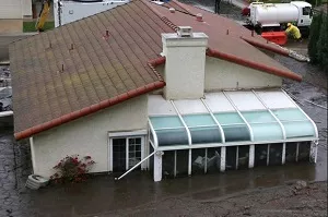
A home damaged by a mudflow is pictured in the area of the 2013 Springs Fire, in Camarillo, California, Dec. 2, 2014. The area was under mandatory evacuation as a powerful winter storm brought heavy rain to southern California burn areas in Ventura, Los Angeles, Orange and San Diego counties. CREDIT: Jonathan Alcorn/Reuters
The impact of severe weather events like droughts and subsequent floods and landslides during heavy rain show that the ability to predict and track weather systems is becoming more critical than ever. The NOAA/NASA Suomi NPP satellite’s Cross-track Infrared Sounder (CrIS) and Advanced Technology Microwave Sounder (ATMS) instruments help forecasters and scientists to monitor and predict drought related weather patterns like Atmospheric Rivers (AR) with greater accuracy. Recent studies have shown that ARs have broken 40 percent of California droughts since 1950. In February 2015, Northern California was barraged by ARs known as the Pineapple Express. The storms caused heavy rains, damaged trees and power lines and impacted travel.
ARs are relatively narrow regions in the atmosphere that are responsible for most of the horizontal transport of water vapor outside of the tropics. ARs that contain the largest amounts of water vapor, the strongest winds, and stall over watersheds vulnerable to flooding can create extreme rainfall, and floods causing landslides. Aerosols from local sources (such as dust and pollution) as well as those transported from remote continents can enhance storm development and influence western U.S. precipitation.
The National Weather Service (NWS) can identify the AR phenomena in current numerical forecast models that utilize CrIS and ATMS data, providing forecasters the capability to give advanced warning of potential heavy rain up to five to seven days in advance. NOAA’s Unique CrIS/ATMS Processing System (NUCAPS) is an operational algorithm to retrieve temperature, water vapor, and trace gases from the Suomi NPP CrIS and ATMS instruments. Monitoring ATMS microwave satellite imagery provides from JPSS satellites provides advanced warning of the presence and movement of these phenomena in the Pacific. For example, during the winters of 2014 and 2015, with the development of AR observatories, a unique collection of ground-based instruments designed to measure the key atmospheric variables in ARs (e.g., wind profiles and column integrated water vapor content), forecasters have been able to monitor their strength and location as they make landfall, thereby improving short-term rainfall forecasts for flash flooding.
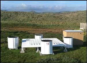
Atmospheric River Observatory, Bodega Bay, California. CREDIT: Clark King, NOAA
Predicting rainfall totals in these events can be challenging as models must identify the details of the duration, timing, and location of AR's as they make landfall. Developing a better understanding of ARs may help to reduce uncertainties in weather predictions and climate projections of extreme precipitation and its effects, including the status of water supply following drought conditions.
From January- March 2015, NOAA, U.S. Department of Energy (DOE), Scripps Institution of Oceanography, NASA, the U.S. Naval Research Laboratory, and the U.S. National Science Foundation engaged in a field campaign focusing on AR’s and aerosols known as CalWater 2015.
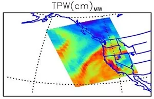
Example of the NUCAPS microwave-only total precipitable water for Jan 27, 2015 using data provided by the Oregon State University direct broadcast site in Corvallis. NOAA P-3 was in the air when these data were acquired.
CalWater 2015 studies AR and aerosol phenomena through a three-prong coordinated approach, including the deployment of state-of-the art monitoring equipment on-board NOAA Research Vessel Ronald H. Brown, airplanes, and at field sites across California through NOAA’s Hydrometeorology Testbeds (HMT) to study water supply availability and the incidence of extreme precipitation events along the West Coast of the United States. The data collected from this experiment will be analyzed and used to help improve precipitation predictions.
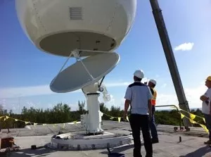
CalWater 2015 also benefits from Suomi NPP’s satellite data. JPSS program’s participation in last year’s CalWater campaign suggested that the NUCAPS data from CrIS and ATMS could improve AR forecasts. JPSS provided NUCAPS temperature and moisture data from CrIS and ATMS data to the 2015 CalWater campaign. The data was acquired by direct broadcast antennas in Corvallis, Oregon and Honolulu, Hawaii, which, due to their proximity, enabled the NUCAPS products to show the context of the entire CalWater field campaign region while the aircraft were in flight in near real-time.
The CalWater 2015 campaign proved that data collected through direct broadcast from Suomi NPP could be used to support future campaign flight operations. More importantly, NUCAPS data will help the CalWater science community to more accurately understand the complex weather system activities associated with the development and landfall of AR phenomena, benefiting weather forecasting.
The full direct broadcast antenna network covers all of North America and provides reliable data to NOAA’s National Center for Environmental Prediction to assist in meeting the nation’s environmental challenges while also allowing local markets to collect data directly from Suomi NPP.
JPSS represents significant technological and scientific advances in environmental monitoring and will help advance weather, climate, environmental and oceanographic forecasting and monitoring with greater accuracy. JPSS delivers key observations for the Nation's essential products and services, including forecasting severe weather like hurricanes, tornadoes, and blizzards days in advance, and assessing environmental hazards such as, droughts, forest fires, poor air quality and harmful coastal waters, helping to secure a more “Weather-Ready Nation.” NOAA is responsible for managing and operating the JPSS program, while NASA is responsible for developing and building the JPSS instruments, spacecraft, and ground system. For more information on the CalWater Initiatives: http://www.esrl.noaa.gov/psd/calwater.