
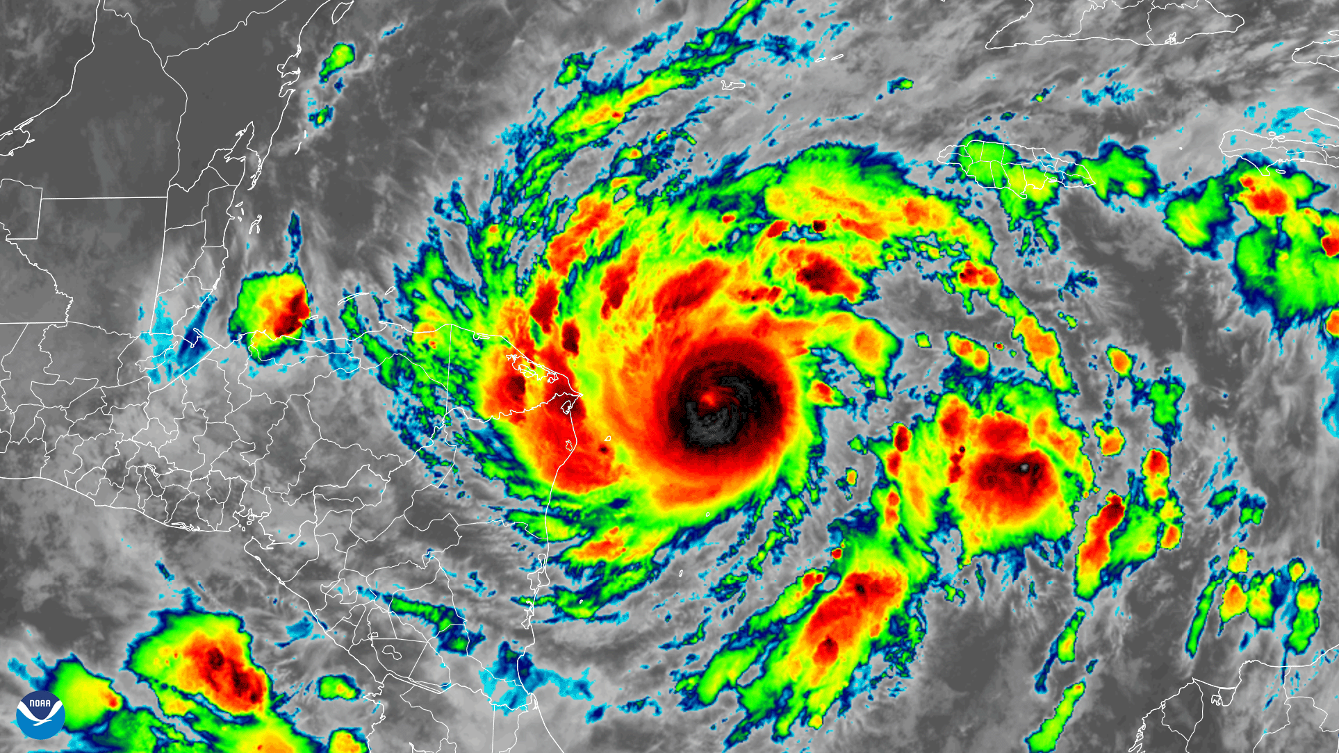
Early on November 2, 2020, the GOES-East satellite watched Tropical Storm Eta strengthen into a hurricane over the Caribbean Sea while heading toward Central America. The imagery above is via its “ clean longwave ” infrared band 13, which helps us visualize atmospheric water vapor and cloud-top temperatures.
The satellite imagery shows the formation of Eta’s eye, which is a sign that the storm is strengthening. In fact, forecasters at NOAA’s National Hurricane Center (NHC) predict that Eta could become a Category-3 or 4 hurricane before making landfall on Tuesday along the northeastern coast of Nicaraga. The NHC also expects a life-threatening storm surge, damaging winds, flash flooding, and landslides across parts of Central America. Heavy rainfall will likely affect Jamaica, southeastern Mexico, El Salvaldor, southern Haiti, and the Cayman Islands.
With the formation of Eta, 2020 continued its trend as a standout. “The 2005 Atlantic hurricane season had a record 28 tropical/subtropical storms—the full Atlantic 21 name list plus six names with the Greek alphabet, which took us through Zeta,” said NHC’s Dennis Feltgen. “But the NHC re-analysis of the 2005 season revealed a short-lived subtropical storm near the Azores Islands. With the formation of Eta in 2020, the 2005 record for most number of tropical/subtropical storms in a single year is now tied at 28.”
According to Philip Klotzbach, research scientist in the department of atmospheric science at Colorado State University Colorado State University, if Eta becomes a major (Category-3+) storm, it would be the fifth this year. Only seven other years in the satellite era (since 1966) have had five or more major hurricanes in the Atlantic by Nov. 2: 1969, 1995, 1996, 2004, 2005, 2010, and 2017. He added that if Eta becomes a Category-4 hurricane, it would be the strongest to make landfall in Nicaragua since Felix in 2007, which was a Category-5.
The GOES East geostationary satellite, also known as GOES-16, keeps watch over most of North America, including the continental United States and Mexico, as well as Central and South America, the Caribbean, and the Atlantic Ocean to the west coast of Africa. The satellite's high-resolution imagery provides optimal viewing of severe weather events, including thunderstorms, tropical storms, and hurricanes.