
NOAA satellites are observing the Earth 24 hours a day to provide data that support the weather forecasts and warnings that Americans benefit from every day. This visualization provides a basic overview of that process - how data and information flows from out in space and into your life.
Polar-orbiting weather satellites are essential assets that provide data that enable forecasters to make more accurate weather predictions three to seven days in the future. In 2015 alone, there were 10 weather and climate disaster events with losses exceeding $1 billion each across the United States. Receiving accurate and timely warnings are of critical importance to protect lives and help prevent costly damage.
One way to expedite the way forecasters receive satellite data is through direct broadcast sites. Data is fed from directly from polar-orbiting weather satellites as they pass over reception antennas in locations across the country, allowing forecasters to have more rapid access to the observations made while the reception antenna is in view of the satellite. NOAA’s National Weather Service (NWS) and JPSS are demonstrating how direct broadcast antennas can improve data flow and allow rapid access to data, thus enhancing forecasters’ ability to predict and monitor severe weather events.
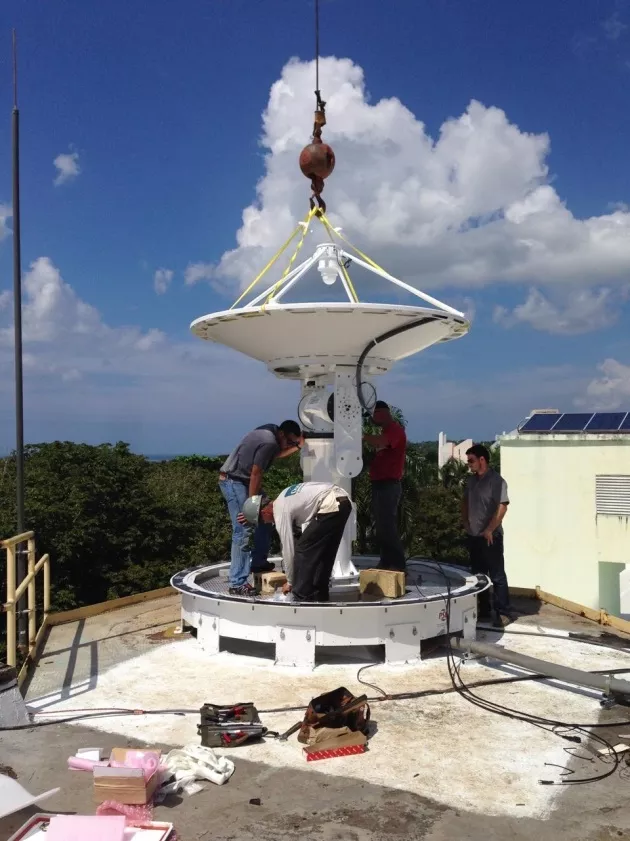
Direct Broadcast Reception Site at the University of Puerto Rico in Mayaguez, Puerto Rico. Credit: CIMSS
On October 23, 2015, the Cooperative Institute for Meteorological Satellite Studies (CIMSS) at the University of Wisconsin-Madison installed a direct readout ground station at the University of Puerto Rico in Mayaguez, Puerto Rico, which receives data from polar-orbiting weather satellites, like the NOAA/NASA Suomi NPP satellite, the first satellite of the Joint Polar Satellite System (JPSS) constellation.
Data from the new antenna will be rapidly available, benefiting the National Weather Forecast Office in the capital city of San Juan and the wider Caribbean and South Florida area. On average, about a quarter of the annual rainfall for Puerto Rico occurs during tropical cyclones. Tropical cyclones form over large bodies of warm water and are capable of generating high waves, heavy rainfall and damaging storm surges. It is critically important to understand the strength of a tropical cyclone before it makes landfall, and having this immediate access to JPSS satellite data through the direct broadcast antenna will facilitate faster local forecasting.
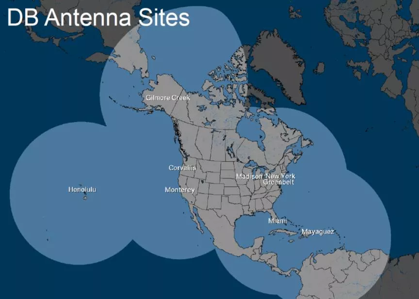
Areal coverage of satellite data captured by the direct readout stations
High resolution imagery and data products from JPSS’ Visible Infrared Imaging Radiometer Suite (VIIRS) will allow forecasters to better monitor tropical cyclone activity, low cloud and fog, and precipitation, which are the primary hazardous weather conditions in their area. With these new capabilities forecasters can expect more accurate coastal flood predictions and improved weather warnings.
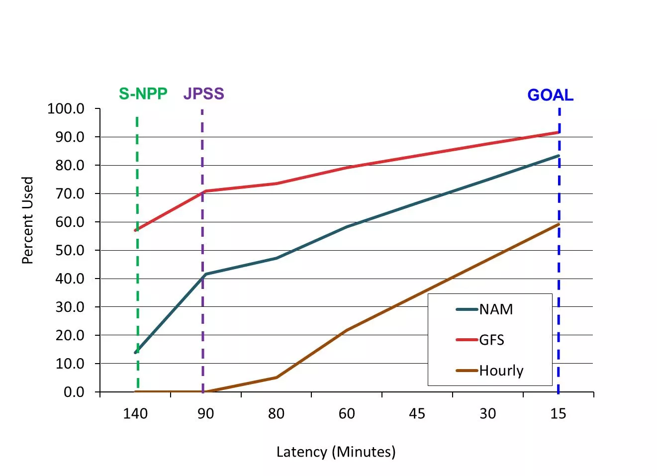
The percentage of data used by models versus latency. The vertical dash lines are the specification latency for Suomi NPP and JPSS. The latency from direct readout stations is within 20 minutes.
The antenna at Mayaguez expands the JPSS Direct Broadcast Antenna Network, which is comprised of sites in Alaska, California, Florida, Hawaii, Puerto Rico and Wisconsin. This Network covers all of North America providing reliable data to NOAA’s National Center for Environmental Prediction (NCEP).
The direct readout sites are capable of receiving data from the sophisticated instruments from all heritage NOAA Polar-Orbiting Environmental Satellites, NASA Earth Observing Satellite, Japan Aerospace Exploration Agency’s (JAXA) Global Change Observation Mission-Water, and European Organization for the Exploitation of Meteorological Satellites (EUMETSAT) Meteorological Operational (MeTOP) satellites. Using all of these satellites provide advanced data, refreshed at least every 3 hours, to forecasters enabling a more thorough picture of rapidly changing weather conditions. This direct broadcast antenna system will be well-placed to continue to receive all future JPSS satellite data.
North American Model area
JPSS leveraged funding from the Disaster Relief Appropriations Act of 2013—commonly referred to as the Sandy Supplemental— to support the acquisition of the Puerto Rico antenna and several other direct broadcast antennas. The purpose was to provide mitigation for any loss of the primary global stored mission data which is downlinked once or twice per orbit, while simultaneously providing overall enhancement to the forecast enterprise. This antenna network has proven important to providing JPSS satellite data quickly to users for operational applications.
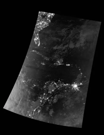
First VIIRS Day Night Band imagery from the new direct readout station at University of Puerto Rico – Mayaguez in Puerto Rico. Notice the large coverage from the Mid-Atlantic States to north-central South America. Credit: CIMSS
The average time it takes to capture the subset of polar satellite data viewable by direct broadcast and turn it into a forecast has been reduced from more than 100 minutes to less than 20 minutes. This enables the use of JPSS data and other polar –orbiting satellite data in NCEP’s regional model which require faster data streams.
“The amount of time required to previously retrieve JPSS data prevented our critical sounder data to be used by regional models, especially those that are updated hourly,” said Mitch Goldberg, PhD., JPSS Program Scientist. “JPSS data will now be able to contribute shorter range forecasts, particularly since the new direct readout network now covers the entire spatial domain of NOAA’s North American Mesoscale model.”
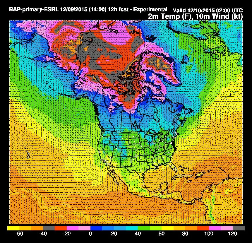
There are three types of NWS forecast systems: the Global Forecast System (GFS), the North American Model (NAM), and the hourly rapid refresh (RAP). The RAP and the NAM have the same model area, but has a shorter data cutoff time. The figure below shows time vs amount of data used in different models, which highlights the importance of the length of time it takes to get the data from the satellite and process it for users.
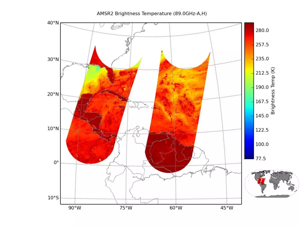
Example of AMSR2 coverage from the Puerto Rico station Credit: CIMSS
Next year, the direct readout network will be expanded to include data from Guam and Japan, allowing coverage from western Pacific region and data from EUMETSAT’s regional network to cover Greenland and the remaining Northern Atlantic where the data takes an extended length of time to process.
Direct broadcast antennas are an essential tool providing essential data needed to meet the nation’s environmental challenges. In addition to the local benefits, the new Puerto Rican antenna will provide a new vital, data source that is incorporated into our Nation's essential decision-making products to help secure a more "Weather-Ready Nation."
To learn more about the Cooperative Institute for Meteorological Satellite Studies, visit http://cimss.ssec.wisc.edu/.