
Temperatures have soared to record-breaking highs across Europe. In the United Kingdom, at least 34 sites have exceeded the previous national record for heat (38.7°C / 101.6°F), with temperatures surpassing 40°C (104°F) on Tuesday, the highest ever recorded in the region. More than 1,000 deaths have been linked to the intense and historic heat wave as well as the wildfires, and thousands of people have been evacuated from their homes.
The sweltering weather has also disrupted travel, health care, and schools. Not only do many buildings in this part of the world not have air conditioning due to the normally mild weather, but various reports have also stated that the intense heat damaged a runway at London’s Luton airport, warped a main road in England, and caused train stations to close or reduce service due to a fear that rails could become damaged.
The extreme weather has also fueled huge wildfires across Spain, Portugal, France, and Greece. Fire officials have battled the blazes throughout these countries for days with the assistance of water bombing planes, and have even begun burning land and cutting down long stretches of forests to prevent the fires from advancing—techniques rarely needed in this part of the world to control fires.
So far, nearly 80 square miles of dry brush and pine forest have been consumed in the Gironde region of southwestern France alone, mainly by the wildfire in La Teste-de-Buch and a second one farther south, and harmful amounts of ozone pollution have been generated as a result. More than 37,000 people have been evacuated.
“We’re facing extreme and exceptional circumstances,” Marc Vermeulen, a regional fire service chief told the Associated Press, while Matthieu Jomain, a spokesman for the regional firefighter unit, said “climate conditions are crazy. It’s an explosive cocktail.”
In Greece, hundreds of firefighters are fighting against high winds to control a wildfire in Mount Penteli, northeast of Athens. This is the second year in a row that wildfires have raged in the area after another historic heat wave in 2021.
Firefighters in Spain have also been battling multiple wildfires in five regions, including two in the northwestern region of Galicia and one in the Gredos mountain range that is spreading toward Madrid. Other fires are raging in Italy, including Tuscany and the northeastern Friuli Venezia Giulia region, and extreme heat warnings are in place for parts of Germany.
NOAA satellites are providing critical data on the wildfires. The Visible Infrared Imaging Radiometer Suite (VIIRS) instrument on the Joint Polar Satellite System’s NOAA-20 and Suomi NPP satellites plays an important role in detecting and tracking wildfires, especially in remote regions. The high spatial resolution from VIIRS allows the instrument to detect smaller and lower-temperature fires. VIIRS also provides nighttime fire detection capabilities through its Day-Night Band, which can measure low-intensity visible light emitted by small and fledgling fires.
Geostationary satellites from our partners around the world, such as the Meteosat satellites operated by our European partners at EUMETSAT, provide timely and potentially life-saving information in a dynamic fire environment. These satellites not only see the smoke generated by these fires but also use their infrared imaging capabilities to show where the hot spots from these fires are in real-time, pinpointing a fire’s location and intensity. They also alert us to the presence of dangerous pyrocumulonimbus clouds and monitor ensuing severe weather conditions.
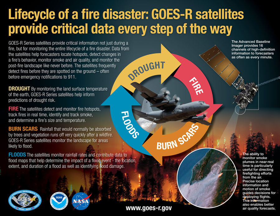
The benefits provided by weather satellites aren’t just seen during a fire but are important in monitoring the entire life cycle of a fire disaster. Data collected are helping forecasters monitor drought conditions, locate hot spots, detect changes in a fire’s behavior, predict a fire’s motion, monitor smoke and air quality, and monitor the post-fire landscape like never before.