
June 2022 saw a record number of fires burning across Alaska, which have compromised air quality and stretched firefighting resources thin. Thus far, more than 1.6 million acres have been consumed, a threshold that has not been reached this early in the fire season in decades. Since 1990, there were only 11 times when a million acres of wildland burned in a single year.
This year has been an unusually active fire season in the region, with abnormally warm and dry conditions that led to more than 300 wildfires igniting in recent weeks. Many of these were sparked by nearly 5,000 lightning strikes from thunderstorms that moved across south-central and southwestern Alaska in early June.
As of June 30, 157 active fires were burning across Alaska. The Alaska Department of Environmental Conservation has issued air quality advisories and episodes for the Central and Eastern Interior, Southcentral, Southwest, and the Aleutians regions of the state.
In the western part of the state near the Yukon Delta, the East Fork Fire has become one of the largest tundra fires on record. The fire has burned more than 250,000 acres since May 31, when it ignited due to lightning. Larger still is the Lime Complex Fire, in the southwestern region of the state, which has burned more than 600,000 acres. According to local reports, heavy smoke from the fire is delaying aerial resources from reaching much of the area.
NOAA satellites are providing critical data on the wildfires. The Visible Infrared Imaging Radiometer Suite (VIIRS) instrument on the Joint Polar Satellite System’s NOAA-20 and Suomi NPP satellites plays an important role in detecting and tracking wildfires, especially in remote regions. The high spatial resolution from VIIRS allows the instrument to detect smaller and lower-temperature fires. VIIRS also provides nighttime fire detection capabilities through its Day-Night Band, which can measure low-intensity visible light emitted by small and fledgling fires.
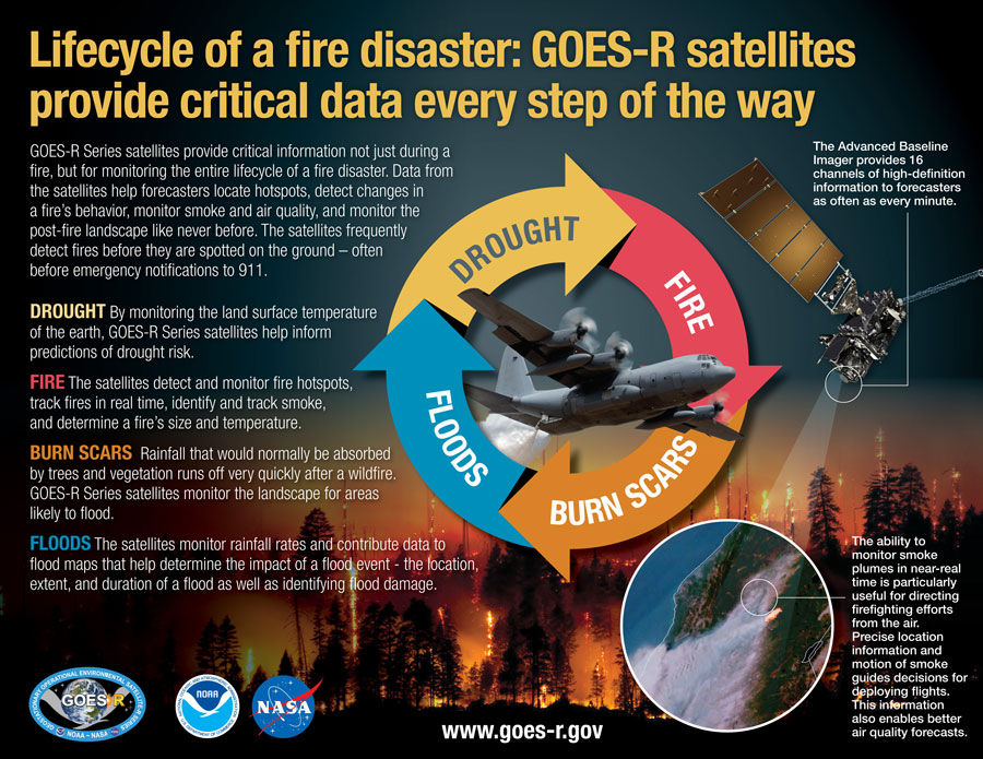
NOAA’s geostationary satellites provide timely and potentially life-saving information in a dynamic fire environment. GOES-16 and GOES-17 frequently detect fires before they are spotted on the ground, which is particularly important in remote areas. These satellites not only see the smoke generated by these fires but also use their infrared imaging capabilities to show where the hot spots from these fires are in real-time, pinpointing where and how intense a fire is. They also alert us to the presence of dangerous pyrocumulonimbus clouds and monitor ensuing severe weather conditions.
The High-Resolution Rapid Refresh (HRRR)-Smoke model produces forecasts of both surface and high-altitude smoke up to 48 hours into the future. The model, which is used by fire crews, first responders and air traffic controllers, builds on the existing High-Resolution Rapid Refresh weather model, which forecasts rain, wind and thunderstorms. It ingests real-time data captured by the JPSS satellites’ VIIRS instrument on the amount of heat released by the fire and combines that with vegetation maps to incorporate what’s burning. (Sage burns differently from Ponderosa Pine, for example.) All of these measurements are mapped to a three-dimensional grid that extends nearly 12.5 miles into the atmosphere, producing detailed updates of the amount of smoke produced, the plume height and the direction the smoke is expected to move.
The benefits provided by the latest generation of NOAA satellites aren’t just seen during a fire but are important in monitoring the entire life cycle of a fire disaster. Data from the satellites are helping forecasters monitor drought conditions, locate hot spots, detect changes in a fire’s behavior, predict a fire’s motion, monitor smoke and air quality, and monitor the post-fire landscape like never before.