
On the morning of April 9, 2021, La Soufrière a volcano on the Caribbean island of Saint Vincent began erupting, spewing ash at least 25,000 feet in the air. The volcano continued to erupt over the next several days, with multiple violent explosions. NOAA satellites captured stunning imagery of the eruptions and provided critical monitoring of the resulting volcanic emissions and ash clouds.
Ash blanketed Saint Vincent and winds carried ash to Barbados, about 120 miles east. The region is preparing for possibly weeks of ashfall events, as volcanic activity shows no signs of dying down. A violent eruption on April 12 generated pyroclastic flows, a high-density mix of hot lava blocks, pumice, ash, and volcanic gas that moves at very high speeds down volcanic slopes. The eruptions also caused widespread power outages and evacuations. La Soufrière last erupted in 1979.
Volcanic emissions often contain gasses and volcanic ash, a major hazard. They also generate complex clouds that can affect local, regional, and even global weather. Given the remote location of most volcanoes and the rapid formation and expansion of volcanic clouds, geostationary satellites, like NOAA's GOES-16 and GOES-17, are the primary tool for monitoring volcanic clouds. Because they orbit 22,236 miles above Earth's equator, at the same speed Earth rotates, GOES satellites have a constant view of the same area. This means they can monitor volcanic eruptions in near real-time. Timely and accurate detection and tracking of volcanic ash are critical for maintaining safety and minimizing economic loss.
A variety of NOAA satellite imagery characterized the eruptions. GOES-16 GeoColor imagery combines data from five of the satellite’s Advanced Baseline Imager (ABI) channels, to create an approximation of what the human eye would see from space. The impressive brown volcanic ash cloud is apparent in GeoColor imagery throughout the event.
The GeoColor imagery also shows white pileus clouds, commonly seen in intense convection. Gravity waves are also apparent in some of the anvil clouds, similar to what is seen in a thunderstorm anvil.
GOES-16 infrared and water vapor imagery show the very cold cloud tops of the volcanic plumes, similar to what we would see with severe thunderstorms. Explosive volcanic eruptions also often generate lightning, and the GOES-16 Geostationary Lightning Mapper (GLM) captured volcanic lightning activity during several of the explosive events.
Specialized RGB, or red-green-blue, data products allow for better discernment of features like volcanic ash and sulfur dioxide (SO2), a noxious gas often produced by volcanic eruptions. SO2 detection is a new capability offered by GOES-16 and GOES-17. The ABI has new infrared channels for detecting this gas that previous GOES imagers lacked.
The Ozone Mapping and Profiler Suite, or OMPS instrument on the JPSS satellite also measures smoke, ash and dust. In the case ofLa Soufrière volcano, this instrument's aerosol measurements were exceptionally large, according to NASA's Colin Seftor, an atmospheric scientist who works with OMPS.
This can indicate that the ash was lofted high in the atmosphere, Seftor said. And indeed, other measurements (including from other satellite instruments) have determined that some of the ash was lofted into the stratosphere.
In this case, ash from the largest explosive events has nearly dissipated, said Mike Pavolonis, physical scientist with NOAA's Satellite and Information Service. Still, the effects that aerosols from volcanoes and smoke from wildfires have when they reach the stratosphere is a topic of great interest to scientists.
At those altitudes, these aerosols can stay in the atmosphere for a long time, and easily circle the Earth for days, weeks, and even months, and their presence can affect the radiation reaching the Earth's surface and therefore temperature, Seftor said, adding that scientists are studying whether these events are on the rise due to climate change. Experts will continue to monitor the ash and SO2 emissions from this eruption to assess any long-term impacts.
Volcanic Ash Advisory Centers (VAACs) are responsible for issuing volcanic ash advisories 24/7. VAAC forecasters use information from NOAA satellites to monitor clouds whose location, evolution and/or spectral properties are consistent with volcanic activity. The satellites can estimate the height of ash clouds, determine the extent of ash, and estimate the amount of ash present. The advisories are also useful to air traffic controllers because large amounts of ash can significantly damage aircraft and are a major safety concern.
Approximately 90% of the world's volcanoes are not regularly monitored for activity. In addition, the large volumes of satellite data now available make manual examination impractical. The need to distill large amounts of data into actionable information for timely volcanic eruption detection led to the development of an automated detection tool. The VOLcanic Cloud Analysis Toolkit (VOLCAT) system automatically detects new eruptive events and issues alerts when new events occur. NOAA satellite data are critical inputs for VOLCAT.
VOLCAT also detects and characterizes volcanic heat signatures that help volcanologists better understand volcanic activity. In addition, VOLCAT tracks and characterizes the volcanic ash and SO2 clouds generated by eruptions.
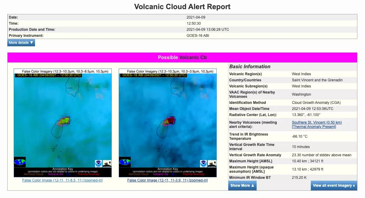
VOLCAT alert for the Soufrière eruption on April 9, 2021.
"The ongoing eruption at La Soufrière illustrates that weather satellites provide a wide range of critical information on volcanic features. The combination of human and machine-generated environmental intelligence allows clouds from volcanic eruptions to be effectively detected, tracked, characterized, and forecasted,” Pavolonis said. “VOLCAT provides a wealth of machine-generated information that complements human insights—helping to prevent valuable satellite-derived information from getting lost within the continuous torrent of environmental data," Pavolonis continued.
NOAA satellites play a crucial role in detecting volcanic activity, alerting those in harm’s way of an eruption, and monitoring the hazards associated with volcanic eruptions.