
Fire weather is heating up across the western United States, exacerbated by an intense heatwave and ongoing severe drought. NOAA satellites are monitoring numerous wildfires and keeping watch on areas primed for ignition. As of June 17, 2021, 33 large fires are currently active, burning more than 400,000 acres in 10 states. More than one million acres have burned across the country so far in 2021.
NOAA satellites zoomed in on several of the major fires burning in the western U.S, including the Telegraph and Mescal Fires in southeastern Arizona, Pack Creek and Bear Fires in Utah, and the Robertson Draw Fire in Montana.
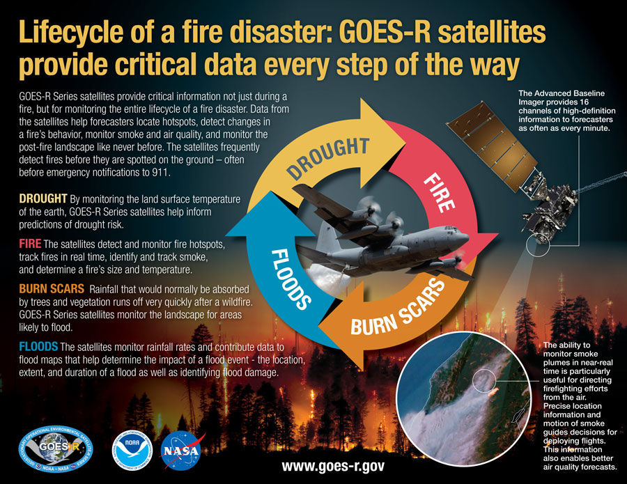
GOES-16 (GOES East) and GOES-17 (GOES West) are monitoring these fires in near-real time. Flying in geostationary orbit, they keep constant watch over the same area, and help to locate fires, detect changes in fire behavior, and predict their motion. They also provide important information about the size, temperature, and intensity of fires that would otherwise be unavailable.
Fire temperature imagery from geostationary satellites is particularly useful to identify new hot spots and the direction those hot spots are moving, especially for fast-growing or newly-formed fires. Specialized imagery that combines data from multiple channels on the satellites’ Advanced Baseline Imager (ABI) instrument, allows both a fire’s hot spot and associated smoke plume to be visualized.
Satellite imagery of several of the fires, including the Pack Creek and Bear Fires in Utah and the Telegraph Fire in Arizona, reveal impressive plumes with thick pyrocumulus clouds, which form when there is enough moisture and atmospheric instability over an intense heat source and smoke.
JPSS satellites feed the HRRR-smoke model, the first weather forecast model in the U.S. to monitor wildfire smoke. The model relies on multiple satellite measurements, such as heat energy, wind speed, rainfall and atmospheric temperature, and combines these data with vegetation maps. The combined data is mapped to a three-dimensional grid that provides information on surface level smoke, and smoke high in the atmosphere. The model also produces a forecast with detailed updates on the height of the smoke plume, the amount of smoke produced and the direction it’s expected to move.
The HRRR-smoke model from June 15, for example, shows smoke from the fires in Arizona and Utah moving north and east across the country.
The benefits provided by the latest generation of NOAA satellites aren’t just seen during a fire but are important in monitoring the entire life cycle of a fire disaster. Data from the satellites are helping forecasters monitor drought conditions, locate hot spots, detect changes in a fire’s behavior, predict a fire’s motion, monitor smoke and air quality, and monitor the post-fire landscape like never before.
Timely satellite imagery is critical, potentially life-saving information in a dynamic fire environment. In the past, incident meteorologists had a single low-resolution image that updated every 15 minutes — typically the image was already 20 minutes old when it arrived at the forecaster. Now, GOES-16 and GOES-17 frequently detect fires before they are spotted on the ground – as early as 10 to 15 minutes before emergency notifications to 911.