
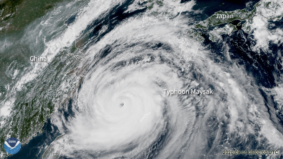
On September 1, 2020, the Himawari-8 satellite, which is operated by Japan Meteorological Agency , viewed Typhoon Maysak spinning near the southern islands of Japan. At the last report by the Joint Typhoon Warning Center (JTWC), the storm’s maximum sustained wind speed was nearly 140 miles per hour, which is equivalent to a Category 4 on the Saffir-Simpson Hurricane Wind Scale.
According to news reports coming out of Japan, “[o]ver 30,000 households in Okinawa had no power as of 11 a.m. local time on Tuesday morning, [and] more than 250 flights have been canceled.” The powerful typhoon is expected to pass west of the main island of Japan and hit South Korea late on Wednesday.
This satellite imagery is using GeoColor, which shows a close approximation to daytime True Color imagery from space, as well as nighttime infrared imagery and city lights. GeoColor uses a total of five AHI bands to render both daytime and nighttime imagery; for daytime, it uses channels 1, 2, and 3, which combine red, blue, and green bands to produce this imagery.
This image was captured by the Advanced Himawari Imager (AHI) on Japan’s Himawari-8 satellite. This satellite, the first unit of the Japan Meteorological Agency's (JMA) third-generation of geostationary satellites, provides visible light and infrared images of the Asia-Pacific region. Himawari's data are vital for global geostationary coverage, which is why NOAA and JMA have agreed to mutual back-up arrangements for their geostationary systems.