
NOAA and the Japan Aerospace Exploration Agency (JAXA) recently entered a new agreement, designed to improve global weather forecasts, while building upon a long, successful partnership between the two agencies. The Memorandum of Understanding (MOU) on Global Observing Satellite Missions, signed last month, will continue NOAA’s ability to provide secure and timely access to global environmental data that protect life and property in the U.S.
Dr. Mitch Goldberg, senior scientist at NOAA’s Satellite and Information Service, highlighted the key elements of the MOU and why it matters.

Q: Why is this new MOU with the Japan Aerospace Exploration Agency important and why enter it now?
A: For both NOAA and JAXA, this agreement is important because it continues the availability to both agencies of high-quality satellite data critical for timely and accurate global weather forecasts. In 2020, the U.S. broke a record for the number of billion dollar disasters in a single year, and typhoons, along with other severe weather, are always a major threat for Japan. So this MOU—with its emphasis on improving forecasts with better satellite data—is in place at the right time.
Q: What are the important elements of the MOU?
A: One of the most important parts of the MOU is having both agencies leverage new satellite technology for better weather forecasts. For example, JAXA will fly the next-generation Advanced Microwave Scanning Radiometer 3 (AMSR3), as a hosted payload on the JAXA Global Observing SATellite for Greenhouse gases and Water Cycle (GOSAT-GW) mission. AMSR3 is an upgrade from the AMSR2, currently flying on GCOM-W, as it includes several new channels that contribute to retrieval of solid precipitation, water vapor analysis in numerical weather prediction (NWP) and robust sea surface temperature retrievals in higher resolution.
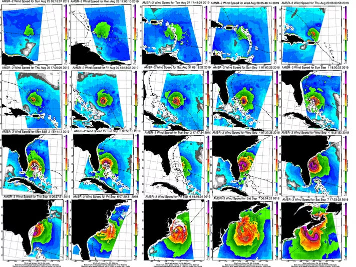
Q: Who uses the current AMSR2 data and what do they use it for?
A: NOAA and its weather colleagues at the U.S. Navy and Air Force use the data. AMSR2 data allow forecasters to define hurricane and tropical cyclone structure more precisely and track the development of the eyewall of hurricanes. Forecasters can also analyze ice extent and concentration for safe ship navigation in the Arctic. AMSR2 provides high spatial resolution information important for predicting heavy rainfall, flash floods, sea surface temperature, snow depth, sea surface wind speed, and marine weather conditions. These data are our only source for sea surface temperature in cloudy conditions, critical for predicting tropical storm intensification. These data also provide important soil moisture information used in weather forecasting models and agricultural and drought assessments. AMSR2’s high spatial resolution surpasses any current NOAA microwave sensor imaging capability and offers much more detailed information than other satellite passive microwave sensors.
Q. How is NOAA collaborating with JAXA on the future GOSAT-GW mission?
A. NOAA will provide ground data acquisition for GOSAT-GW in exchange for access to AMSR3 data, including direct broadcast of AMSR3 data at specified locations in the United States for reduced latency (more rapidly available) data. JAXA will provide JAXA software to NOAA to assure that basic data products are consistent. NOAA and JAXA will work together to use data from AMSR3 and data from the NOAA Joint Polar Satellite System (JPSS) for water cycle applications.
Q. How is GCOM-C data used?
A. GCOM-C Second generation GLobal Imager data, also covered in the MOU, are used for ocean color applications, for example investigating Harmful Algal Blooms that affect the U.S. Great Lakes and U.S. coastal and inland waterways. These data are also useful for ice applications, air quality applications, snow and ice covered area, snow and ice surface temperature, snow grain size of shallow layer and land applications.
Q. How is NOAA collaborating with JAXA on GCOM-C?
A. NOAA has provided data from the NOAA Marine Optical Buoy network for use in calibration of the GCOM-C SGLI and has offered JAXA the opportunity to join NOAA ocean color ship cruises. We are working jointly to use GCOM-C data together with data from the NOAA Joint Polar Satellite System.
Q: What is a final takeaway about the MOU you want readers to remember?
A: NOAA views this MOU as an opportunity to work with JAXA to continue the use of AMSR data and avoid a gap in availability required for global weather forecasts and to recognize Japan’s continued valued leadership role in global Earth observation. We’re looking forward to the seeing benefits of this MOU and work on others in the future.
###