
January 21, 2021
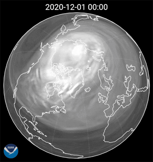
This swirling image of the polar vortex was made possible by data from several different polar-orbiting satellites between Dec. 3, 2020 and Jan. 16, 2021. The imagery was created using the information from the ATOVS data processing system aboard the NOAA-19 satellite, along with Europe’s MetOP-1 and -2 satellites, which host a NOAA instrument called the High Resolution Infrared Radiation Sounder (HIRS).
Visualizations like this help climate scientists at NOAA and elsewhere see the movement and fluctuations in the polar vortex that has been affecting weather patterns in the Northern Hemisphere this winter.
Just what is the polar vortex we hear so much about? It is an area of low pressure—or swirling cold air—that centers around the North and South Poles, higher up in a region of the atmosphere called the stratosphere --the same region that hosts the Earth’s ozone layer. During winter, the polar vortex at the North Pole expands, sending cold air southward. This happens fairly regularly and is often associated with outbreaks of cold temperatures in the United States.
Information courtesy of Amy Butler of the Chemical Sciences Laboratory and imagery compiled by Zachary Lawrence at the Physical Sciences Laboratory.