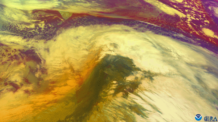
Over the course of 48 hours from Dec. 30, 2020 to Jan. 1, 2021, the Himawari-8 satellite, operated by our partners at the Japan Meteorological Agency, watched a powerful low-pressure system intensify and move across the northern Pacific Ocean toward Alaska. Winds were recorded at more than 100 mph and some wave estimates were possibly higher than 45 feet over the open water.
This storm not only underwent bombogenesis , dropping nearly 60 mbar in 24 hours and 75 mbar in 36 hours , but also set a record for the lowest central pressure of an extratropical storm— 921 mbar —on New Year’s Eve. In 2020, only two Atlantic hurricanes had lower pressure readings: Hurricane Eta and Iota. However, hurricanes gain strength from warm ocean waters rather than extreme temperature gradients in the mid-latitudes, which fuel these storm systems.
The imagery above shows the storm via a product called Air Mass RGB , which examines temperature and moisture characteristics of air masses to understand the environment surrounding large storm systems. Here, high thick clouds are white, mid-level clouds are tan/salmon, warm air masses are green, low-level clouds are dark green, and colder air masses are dark blue.
This image was captured by the Advanced Himawari Imager (AHI) on Japan’s Himawari-8 satellite. This satellite, the first unit of the Japan Meteorological Agency's (JMA) third-generation of geostationary satellites, provides visible light and infrared images of the Asia-Pacific region. Himawari's data are vital for global geostationary coverage, which is why NOAA and JMA have agreed to mutual back-up arrangements for their geostationary systems.