
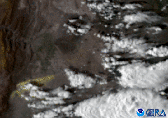
On Dec. 18, NOAA’s GOES East satellite caught a haboob, or sandstorm, as it swept through the dry Argentine plains, as strong winds caused widespread damage to trees and structures in the town of La Pampa and its surroundings. Winds in the region blew more than 60 miles per hour at their peak; this comes about a week after another summer dust storm in Argentina affected Lake Mari Menuco, 350 miles away.
This GOES satellite imagery above (similar to that of Lake Mari Menuco ) is displayed as a “GeoColor'' product, overlaid with the Cooperative Institute for Research in the Atmosphere’s dust product. Its algorithm picked the leading edge as a bright yellow, which is most likely due to higher dust concentration. It provides as close an approximation to daytime True Color imagery as is possible and allows for intuitive interpretation of meteorological and surface-based features. This gives people, with varying degrees of technological backgrounds, much easier access to weather data and imagery with a more naturalistic view of our planet from above.
The GOES East geostationary satellite, also known as GOES-16, keeps watch over most of North America, including the continental United States and Mexico, as well as Central and South America, the Caribbean, and the Atlantic Ocean to the west coast of Africa. The satellite's high-resolution imagery provides optimal viewing of severe weather events, including thunderstorms, tropical storms, and hurricanes.