
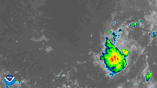
On the morning of July 22, 2020, NOAA’s GOES-East satellite zoomed in on newly-formed Tropical Storm Gonzalo, the seventh named storm of the 2020 Hurricane Season.
As of 11:00 a.m. AST , the storm was moving westward and was expected to move near or over the southern Windward Islands this weekend. The National Hurricane Center predicts it could strengthen to a hurricane as soon as Thursday before losing some steam as it reaches the Lesser Antilles.
Gonzalo is notable for a few reasons. It is the earliest “G” storm on record in the tropical Atlantic, which was previously held by Tropical Storm Gert on July 24, 2005. Also, according to the Washington Post , “Gonzalo’s development is the latest in a string of impressive milestones claimed by the record-busy start to the 2020 hurricane season. This year has already featured the earliest C, E and F storms on record—Cristobal, Edouard and Fay—and Gonzalo just snagged its own record. The average date of an Atlantic hurricane season’s seventh named storm is Sept. 16.”
The GOES-East geostationary satellite, also known as GOES-16, keeps watch over most of North America, including the continental United States and Mexico, as well as Central and South America, the Caribbean, and the Atlantic Ocean to the west coast of Africa. The satellite's high-resolution imagery provides optimal viewing of severe weather events, including thunderstorms, tropical storms, and hurricanes.