
As part of the River Ice and Flooding Initiative, NOAA scientists with the Joint Polar Satellite System are working with experts in academia through the JPSS Proving Ground and Risk Reduction (PGGR) Program to help communities identify the risk of ice jams and prepare for these hazards.
Ice jams along rivers are common occurrences during the winter and spring and can cause hazardous conditions for local residents.
When a frozen river begins to thaw and water levels rise, large ice chunks can break off and obstruct the natural flow of the river. When this occurs, the water that is held back can cause upstream flooding. If one of these ice jams breaks, the rushing waters can create flash flooding downstream.
That is why NOAA scientists with the Joint Polar Satellite System are working with experts in academia through the JPSS Proving Ground and Risk Reduction (PGGR) Program to help communities identify the risk of ice jams and prepare for these hazards. This effort is known as the River Ice and Flooding Initiative. The PGRR Program responds to this type of real-world environmental events using JPSS satellite data.
An Alaskan Community at Risk
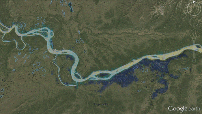
In May 2013, an ice jam formed on the Yukon River downstream from the village of Galena, Alaska. Waters rose 6.5 feet above flood stage, the established point at which a body of water poses a hazard to lives, property, or commerce, for a three day period. The record level flooding caused half of Galena’s occupied dwellings to be deemed uninhabitable.
Thankfully, two teams of scientists from City College of New York and George Mason University had been working on PGGR products to monitor and track ice and flooding conditions using data from the NOAA/NASA Suomi NPP satellite, the flagship satellite in NOAA’s fleet of polar-orbiting satellites.
Working together, the teams were able to combine satellite imagery from multiple sources with river gauge data which was made available to Alaskan decision-makers to assist them in their response to the disaster.
Satellite data are especially crucial in the Alaska region where NOAA’s Joint Polar Satellite System provides critical data for nearly all weather forecasting, filling gaps over areas that are not well covered by other ground-based observing systems.
2016 Brings Expanding Use of River Ice and Flooding Products
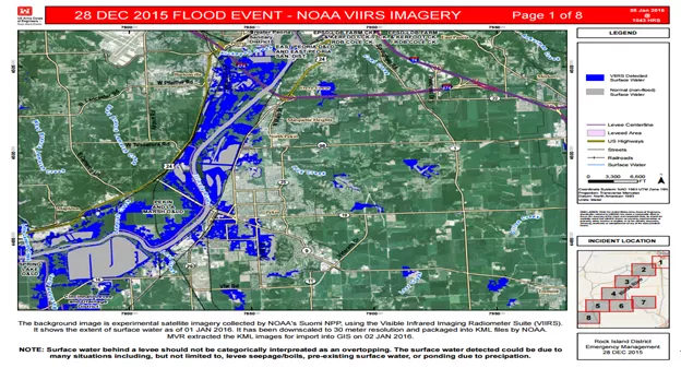
The George Mason University River Flooding Product recently used in December 2015 to monitor and track severe flooding that impacted the Midwest River Basins and the Mississippi River Valley. This flooding was tied to an extensive period of heavy rain in Missouri, Illinois and areas south.
NOAA’s National Weather Service gave the product to the Army Corps of Engineers (USACE), which then used it to visualizeflooding along sections of the Illinois River. Thanks to the University of Wisconsin- Madison’s Space Science and Engineering Center (SSEC), the River Flooding Product is available on its RealEarth website.
These visualizations were so compelling that the Corp requested updates when JPSS’s satellite passed over the area.
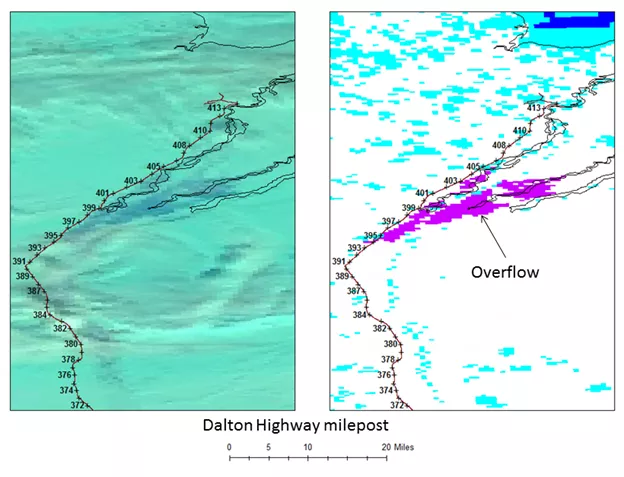
This year in Alaska, the Alaska Department of Transportation will use the River Ice and Flooding Product to help minimize flooding impacts over the Dalton Highway, a major transportation route (and an important economic corridor) that runs just north of Fairbanks and a few miles from the Arctic Ocean and the Prudhoe Bay oil fields.
The River Ice and Flooding Initiative is just one example of how imagery from JPSS satellites will remain a critical resource to increase the timeliness and accuracy of public warnings and forecasts of severe flooding, thus reducing the potential loss of human life, enabling better preparedness, and building more resilient communities.