
River flooding poses a serious threat to communities across the United States, endangering roughly 41 million Americans and putting an estimated $5.5 trillion in assets at risk. It occurs when heavy rainfall causes rivers, creeks or streams to overflow their banks, often affecting areas far beyond where the rain fell. Peak flooding can sometimes arrive days after a storm, making it difficult to anticipate the full impact. River floods can severely damage infrastructure, destroy crops, disrupt ecosystems, contaminate water supplies and displace entire neighborhoods. These widespread impacts highlight the critical need for accessible tools that can accurately predict where flooding is anticipated to occur, so communities can prepare and respond effectively.
To meet this need, NOAA’s National Water Center has developed experimental Flood Inundation Mapping (FIM) Services to better depict where river flooding is happening and where it could spread. These interactive online maps display flood extent down to the street level, creating “flood footprints” of areas already underwater or at risk over the next five days. FIM maps are a vital support tool for emergency managers who require precise information to make time-sensitive decisions, such as issuing evacuation orders. Once fully rolled out in 2026, FIM maps will cover about 3.4 million river miles, greatly enhancing emergency preparedness and response efforts for floods nationwide.
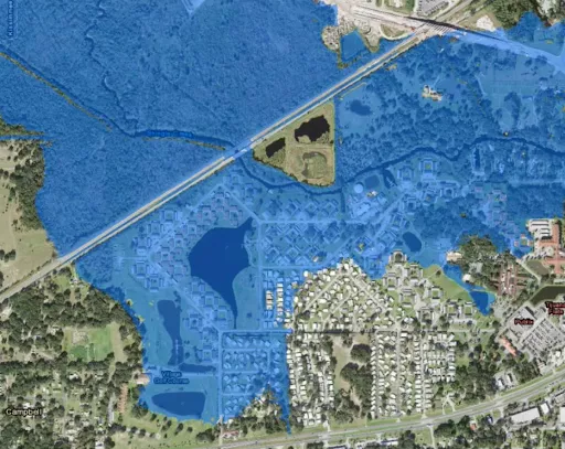
In this example FIM Services map, blue shading marks the areas of a neighborhood in Campbell, Florida projected to experience river flooding over the next five days, including many houses and businesses.
Accurately predicting and mapping inundation events requires understanding the complex relationship between weather and the water cycle. The National Water Model—a hydrologic modeling framework that simulates observed and forecast streamflow across the U.S.—serves as the core of NOAA’s FIM Services. Like other hydrologic models, it relies heavily on numerical weather prediction, which uses current atmospheric observations to forecast future weather, such as precipitation and humidity. This information is important for estimating how rivers will respond to weather, including when and where they might overflow.
Some of the most impactful observations used in numerical weather prediction come from atmospheric sounders onboard low Earth orbit (LEO) satellites. Instruments such as the Advanced Technology Microwave Sounder (ATMS) and Cross-track Infrared Sounder (CrIS), onboard Joint Polar Satellite System (JPSS) satellites, measure radiation emitted from Earth’s surface and atmosphere. Scientists use these measurements to infer how atmospheric temperature and moisture vary with altitude. The radiance data itself is fed into numerical weather prediction models, significantly improving their performance by reducing model errors.
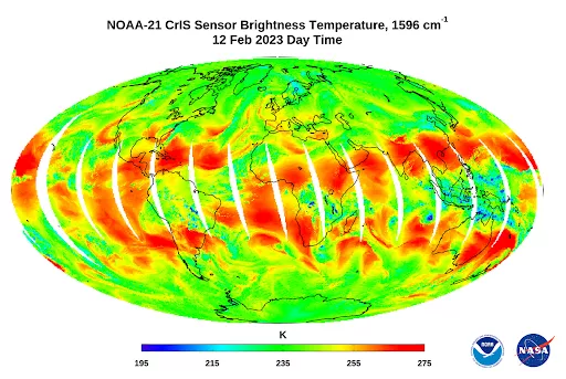
NOAA-21 CrIS’s first light brightness temperature image, taken in the 1596 cm⁻¹ channel on February 12, 2023, reveals large-scale waves of water vapor and clouds in the upper tropospheric. Red areas indicate drier air, which allows the CrIS sensor to “see” deeper into the atmosphere. Image generated using NOAA-21 Preliminary, Non-Operational Data. Courtesy: NOAA/NESDIS/STAR/CrIS SDR team.
CrIS and ATMS have complementary capabilities that enhance their value when used together. CrIS, a hyperspectral infrared sounder, measures infrared radiation to deliver high-resolution vertical profiles of atmospheric temperature, water vapor, and other variables. However, it is limited in cloudy conditions, as infrared energy cannot penetrate thick cloud cover. ATMS, a microwave sounder, has a lower vertical resolution, but can capture similar information through most cloud cover, making it effective in a wide range of weather scenarios. Because each instrument performs best under different conditions, data from both are routinely integrated into numerical weather prediction models to provide a more complete picture of the atmosphere and improve forecast accuracy.
LEO sounders provide essential data that strengthen the accuracy and effectiveness of hydrologic modeling, enabling more accurate flood inundation mapping and timely decision-making. Data from instruments like CrIS and ATMS improve weather forecasts, which in turn enhance the National Water Model’s river simulations—ultimately strengthening FIM capabilities. This integration of satellite data into decision support tools demonstrates the critical importance of LEO observations in advancing flood preparedness. To learn more about this connection, see The Link Between JPSS Sounders and Flood Inundation Mapping on page 126 of the 2024 LEO Science Digest.