
Alaska’s remote communities rely heavily on satellite observations to support critical daily operations, from ensuring safe flight navigation to delivering crucial weather updates. In a state where road systems are limited or nonexistent, data acts as lifelines, bridging the gap in accessibility. As winter weather intensifies and brings challenges like heavy snow, ice, and extreme cold, the need for timely and accurate satellite data becomes even more critical for sustaining daily life across the vast and often harsh environment.
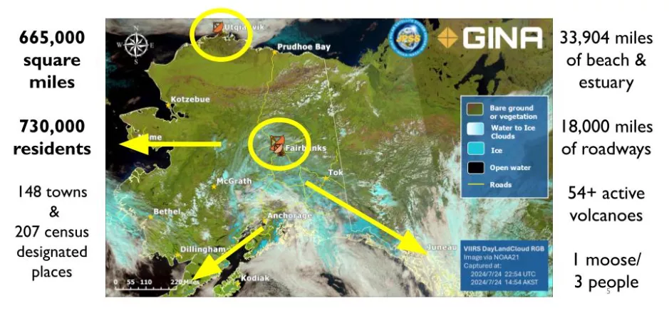
The image above offers a clear view of Alaska’s vast size and unique layout. The circles highlight the network of direct broadcast stations across the state, showing how information flows through antennas to connect remote communities. These stations play a crucial role in supporting organizations and institutions—like universities, the National Weather Service, and decision-makers—ensuring the smooth functioning of daily activities across the region. [Credit: Jen Delamere]
As 2025 begins, NOAA is building on insights from the Alaska NextGen Satellite Workshop, held in September 2024 in collaboration with the University of Alaska Fairbanks. This Anchorage-based event, co-hosted by NOAA and the University of Alaska Fairbanks, brought together Alaskan communities, NOAA leadership, and satellite product developers to explore solutions for delivering satellite data to Alaska’s remote and diverse regions.
The workshop highlighted the essential role of Low Earth Orbit (LEO) satellites in addressing the unique challenges and opportunities faced by Alaskan communities.
Satellite data is essential to daily operations, especially in rural areas where limited road infrastructure makes air travel a critical lifeline. Accurate weather information ensures the safety of flights, facilitates the coordination of medical and food aid, and supports overall community resilience.
However, significant barriers to broadband and Wi-Fi access in many Alaskan communities complicate the delivery of vital satellite data. During the Alaska NextGen Satellite Workshop, the LEO team identified an urgent need for innovative solutions to overcome these connectivity challenges, ensuring that communities can fully use NOAA’s satellite products to protect lives and property.
Jen Delamere, NOAA’s Director of the Geographic Information Network of Alaska, emphasized the importance of these efforts during the workshop, stating, “The [NOAA] JPSS [Joint Polar Satellite System] Program has provided critical guidance and products to weather forecasting and hazard management across Alaska for over a decade. This stakeholder conference showed there is more yet to be done with data delivery and future LEO satellites. Alaska’s motto, ‘North to the future,’ will continue to guide us all.”
The lessons from the workshop underscore the importance of tailored, community-focused solutions. Looking ahead, the LEO team plans to develop a strategic roadmap to address the challenges identified.
This plan will prioritize strengthening partnerships with NESDIS programs and regional collaborators to enhance the accessibility and usability of satellite data in Alaska. By integrating these insights into broader decision-making processes and operations, NOAA aims to ensure satellite technology continues to be a vital resource for the state.