

Credit: NOAA/NESDIS
As a winter storm brought its fury to Washington, D.C. and the Mid-Atlantic region on January 6, 2025, NOAA’s National Environmental Satellite, Data, and Information Service (NESDIS) played a pivotal role in monitoring and supporting the nation’s response to this significant weather event. NOAA satellites and data systems enabled accurate forecasting and critical decision-making, proving once again why they are essential to protecting lives, infrastructure and the economy.
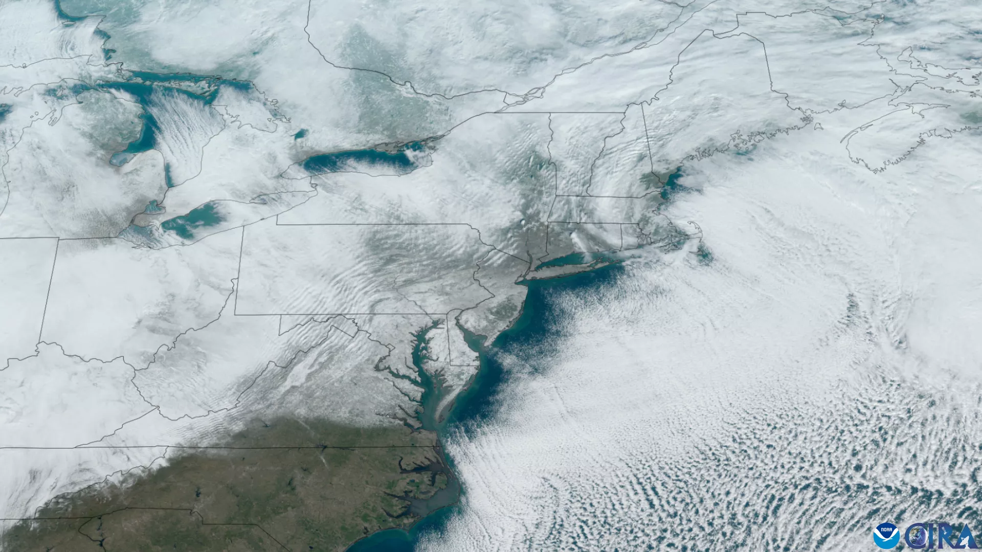
Credit: CIRA
NESDIS: Eyes in the Sky for Winter Weather
During the winter storm, NOAA’s Geostationary Operational Environmental Satellite (GOES-16) and the Joint Polar Satellite System (JPSS) tracked the storm’s progression. These satellites provided near-real-time data on storm dynamics, including precipitation intensity, cloud movement, and atmospheric conditions. This information was vital for NOAA’s National Weather Service (NWS) to issue timely and precise forecasts.
GOES-16, positioned high above the Earth, offered continuous monitoring of the storm’s development as it moved from the Central Plains into the Mid-Atlantic. Meanwhile, JPSS satellites delivered detailed temperature, moisture, and snow cover data, allowing meteorologists to refine snowfall predictions.
Snowfall and Impact Zones

Credit: NOAA/NESDIS
The winter storm left a significant mark on the region, impacting states across the Mid-Atlantic and beyond:
- Washington, D.C.: Snow accumulated over five inches by the evening and halting normal activity across the city, including shutting down the federal government.
- Maryland: Areas around Baltimore and the Maryland suburbs recorded six to twelve inches, with travel disruptions widespread.
- Virginia: Northern Virginia had snowfall totals of up to a foot in some areas, causing school closures and affecting major highways.
- Ohio Valley and Central Plains: Earlier in the storm’s journey, heavy snowfalls impacted communities in Missouri, Kansas, Kentucky, and Ohio.
NESDIS Supporting Critical Sectors
The accurate and timely data that NOAA satellites provided informed decision-making across key sectors, mitigating the storm's impacts:
- Critical Infrastructure: Utility companies pre-positioned crews to address potential power outages, while transportation agencies deployed snowplows and salt trucks in advance of the storm.
- Economic Activity: Businesses leveraged NOAA- forecasts to minimize disruptions, enabling remote work and operational adjustments.
- Community Preparedness: NOAA forecasts allowed schools and local governments to prepare for closures and ensure resident safety.
- Emergency Management and National Defense: Military bases in the region used NESDIS data to adjust operations and maintain safety for personnel and equipment.
Protecting the Nation Through Data
This winter storm reminded millions of the challenges posed by extreme weather while NESDIS reaffirmed its mission of safeguarding lives, critical infrastructure and the economy. By providing actionable data and supporting a seamless flow of information, NESDIS ensures that decision-makers and communities are prepared for whatever the skies bring next.