
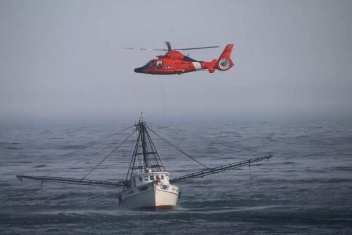
As part of the SARSAT system, NOAA satellites assisted in the resue of a distressed vessel off the coast of Virginia and a small plane that crashed in the Cascade Mountains.

If a plane crashes on a remote mountain or a boat captain encounters trouble far off shore, will anyone hear their pleas for help? Thanks to 406 MHz distress beacons and an international satellite constellation that includes NOAA spacecraft, the answer is yes!
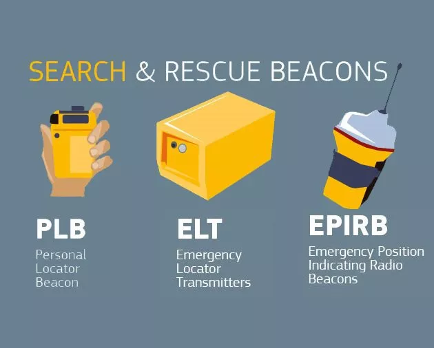
406MHz beacons are used on sea faring vessels (EPIRBs), by outdoor enthusiasts (PLBs) andand on aircraft (ELTs), and on this 406 Day, we want to take a moment to remind 406 MHz beacon owners to update their NOAA registration. (To register your 406MHz distress beacon, visit the NOAA website.)
Put simply, NOAA’s satellites are constantly listening for 406MHz distress beacons to be activated! For example, on April 2, 2017, a small General Aviation aircraft crashed in an isolated part of the Olympic Mountains in Washington State. A distress signal from the plane’s Emergency Locator Transmitter (ELT) was detected by GOES West and the new Mid-Earth Orbiting Search and Rescue (MEOSAR) satellite constellation, which the spacecraft relayed to the NOAA-operated SARSAT United States Mission Control Center (USMCC) in Suitland, Maryland. USMCC then notified the United States Air Force Rescue Coordination Center (AFRCC) at Tyndall Air Force Base in Florida. Within minutes, the AFRCC dispatched a U.S. Navy Helicopter Rescue team from Naval Air Station Whidbey Island Search and Rescue in Washington State, as well as members from the Washington Air Search and Rescue team, to the crash site. The combination of data about the plane’s location from the 406MHz signal, as well as the homing capability of the ELT, allowed rescue teams to pin point the plane’s location and perform a rescue on the side of the snow-covered Jupiter Mountain. Fortunately, the pilot and passenger survived the crash, although minor injuries were reported.
Rescues like this one not only highlight the team work among NOAA, the United States Air Force, the United States Navy, state agencies, and search and rescue organizations, but also the life-saving capabilities of 406MHz beacons, which when properly registered, helps first responders take the "search" out of search and rescue.
A week earlier, on Sunday, March 26, 2017, NOAA played key role in rescuing fisherman off the coast of Virginia.
At approximately 7:00 am, the captain of a fishing vessel located about 50 miles east of Chincoteague, Virginia, suffered stroke-like symptoms. The crew on board the vessel activated an Emergency Position Indicating Radio Beacon (EPIRB), which sent an emergency signal through NOAA weather satellites to the United States Mission Control Center (USMCC). Within minutes, the location of the ship in distress was transmitted to the USCG as well as the registration information associated with the EPIRB from the USMCC. This information allowed the USCG to direct a rescue helicopter the vessel and conduct the rescue quickly. (To read more about this rescue, go to goo.gl/T96KIH.)
Search and Rescue (SAR) instruments are flown on Low Earth Orbiting and Geostationary Orbiting satellites. These instruments detect and locate distress signals quickly from emergency beacons employed on aircraft, boats, as well as from hand-held personal locator beacons. When a NOAA satellite pinpoints the location of a distress signal, the information is relayed to the SARSAT Mission Control Center at NOAA’s Satellite Operations Facility in Suitland, Maryland. From there, the information is quickly sent to a Rescue Coordination Center, operated by either the U.S. Air Force for land rescues, or the U.S. Coast Guard for water rescues.
NOAA satellites are part of the international Search And Rescue Satellite Aided Tracking System (or SARSAT), and, in 2016, assisted in the rescue of 307 people — the highest number since 2007. For more information about the 2016 SARSAT rescues , visit the NOAA website.
To learn more about how the SARSAT system and how it works, visit the NOAA website.