
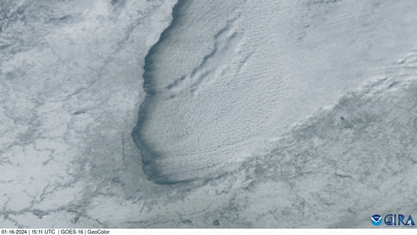
On Jan. 16, 2024, NOAA’s GOES East satellite used its Advanced Baseline Imager (ABI) to capture this mesmerizing GeoColor image of cloud streets streaming off Lake Michigan. A winter storm moved through the Midwest over the weekend, bringing bitter cold and snow to the Great Lakes region.
These parallel rows of cumulus clouds are common in early-to-mid winter. When extremely cold air moves over the unfrozen, relatively warmer lake water, columns of heated air begin to rise off the lake surface. As the rising, warmer air hits the cold air above it, the moisture condenses into cumulus clouds, then cools and sinks on either side. This rising and sinking motion creates parallel cylinders of rotating air that line up in the direction of the prevailing wind (usually out of the northwest). Large temperature contrasts between the surface air and lake water can deliver heavy lake effect snow on the downwind shores of the lakes.
The GOES East geostationary satellite, also known as GOES-16, keeps watch over most of North America, including the contiguous United States and Mexico, as well as Central and South America, the Caribbean, and the Atlantic Ocean to the west coast of Africa. The satellite's high-resolution imagery provides optimal viewing of severe weather events, including thunderstorms, tropical storms, and hurricanes.