


Phenomena: Wildfires, Smoke
Satellite: GOES East (GOES-19)
Product: GeoColor, Fire Temperature
Instrument: Advanced Baseline Imager
Timespan: May 12, 2025 (16:30 UTC – 22:26 UTC)
Over the course of several hours on May 12, 2025, NOAA’s GOES East (GOES-16) satellite captured the heat signatures and smoke plumes emanating from three large wildfires burning in the Arrowhead region of northeastern Minnesota—the Jenkins Creek, Camp House, and Munger Shaw fires.
The Jenkins Creek Fire, which was first detected on May 12, rapidly spread from 6,800 acres on May 13 to more than 15,500 acres by the morning of May 15. All three fires are burning in remote areas of the Cloquet Valley State Forest, where extremely hot, dry and windy conditions have made firefighting efforts especially challenging. The situation is further complicated by an abundance of dry, grassy ground cover and dead trees in the area, many of which were killed by budworms. These pests are known for devastating large stands of balsam fir and spruce trees across the state.
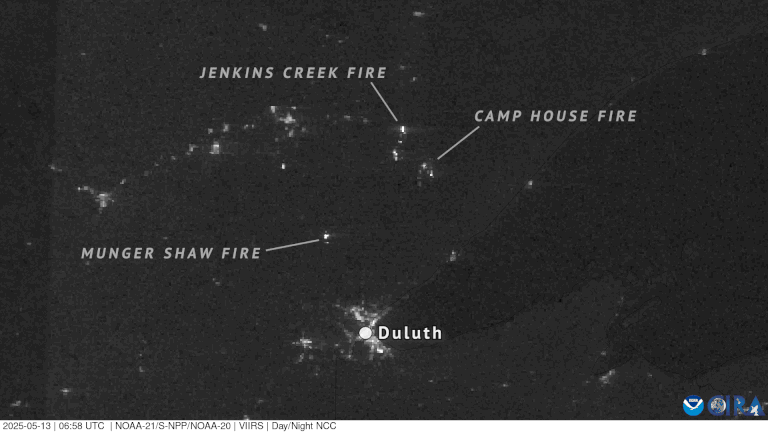
NOAA’s JPSS Program satellites captured Day-Night band imagery as the fires burned brightly at night on May 13, 2025.
As NOAA’s JPSS Program satellites passed over the region on May 13, 2025, they captured the illumination for the blazes during the nighttime hours. The VIIRS instrument on the JPSS satellites has Day-Night band imagery, used to capture low-light emission sources under varying illumination conditions, including city lights and the glow of wildfires.
According to the most recent reports, the three fires have consumed a total of more than 37,000 acres, and at least 146 structures have been destroyed.
In an era of increasingly severe wildfires, NOAA satellites provide indispensable tools for protecting communities and managing natural disasters. Their data offers insights into fire dynamics, including location, duration, size, temperature, and power, as well as smoke dispersion, improving air quality forecasts and aiding firefighting efforts.