
NOAA Prevents Pilots From Flying Blind
Despite the hazards inherent to air travel, U.S. civil and military aviation is by far the safest form of transit. This is in part due to complementary radar, command and control systems, and satellite-driven weather forecasting. Atmospheric conditions like dust, clouds, ice, and water vapor are a prime concern to aviators. NOAA’s Low Earth Orbit (LEO) and geostationary satellites (GEO) satellites provide combined overwatch for potential atmospheric dangers, protecting valuable aircraft and human assets. Volcanic ash is a dramatic example: in 2010, the eruption of Eyjafjallajökull created a plume of heavy ash that interrupted enormous swaths of European airspace for almost a week. The microwave and infrared sounders flying on Joint Polar Satellite System (JPSS) work in conjunction to provide three-dimensional profiles of the physical properties of the atmosphere, revealing what pilots will find above, below, and even inside the clouds.
Accurate forecasts fueled by satellite data allow warfighters to plan operations with unprecedented efficiency and safety. Wind patterns, cloud cover, water vapor, and visibility measurements from satellites help meteorologists identify turbulence events. Flight planners use that information to plan routes to avoid the most dangerous turbulence.
Take-off and landing are the most dangerous phases of flight, as lower speeds and altitude reduce safety margins. GEO satellites provide immediate detection of potential weather issues and threats. Real-time “eye in the sky” and model-driven forecasted conditions arm air traffic controllers with the environmental intelligence to select the safest flight paths as well as takeoff and landing approaches. This is particularly important for flight operations at sea, which require highly specific wind conditions to launch and recover aircraft, even requiring ships to change course and speed to create the correct conditions.
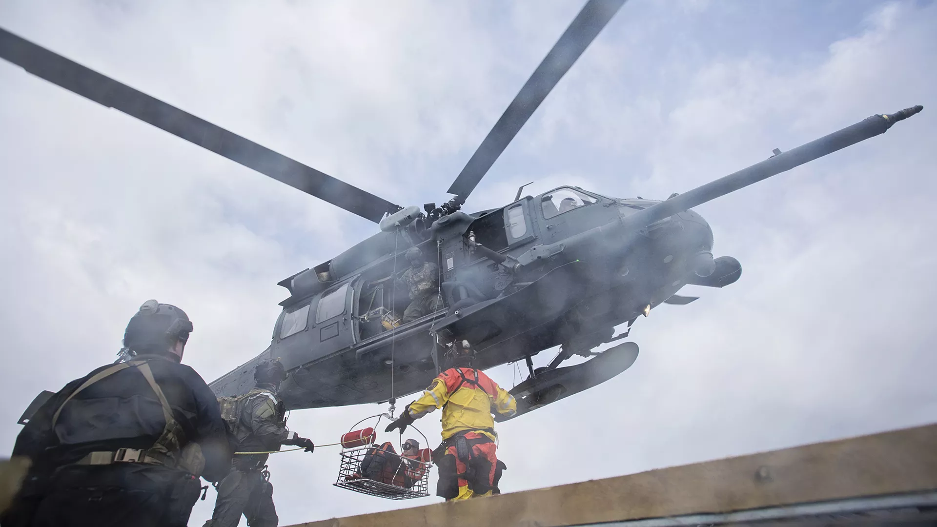
Members of the Alaska Air National Guard training for a civilian rescue operation via helicopter. (U.S. Air National Guard photo by Staff Sgt. Edward Eagerton/released)
NOAA also supports the Department of Defense (DoD) mission by transferring Geostationary Operational Environmental Satellites (GOES) satellites that have completed their NOAA mission to the U.S. Space Force. Currently, the satellite that previously operated as GOES-15, renamed Electro-optical Infrared Weather System-Geostationary 2 (EWS-G2), operates over the Indian Ocean. In its new position, EWS-G2 provides critical weather data for planning and executing air, land, and maritime military operations across the region.
Solar activity can also disrupt any technologies that rely on radio or microwave transmissions, including radio communications and radar signatures, including GPS functionality. GPS radio signals pass through the Earth’s upper atmosphere as they travel from the satellite to the receiver on the ground. When a space weather event disturbs that area, GPS receivers cannot properly determine position. Space weather also increases radiation in the upper atmosphere, which is especially hazardous to pilots and crew for polar flights. Finally, when disruptions do occur, space weather monitoring aids operators in satellite anomaly attribution, helping distinguish natural effects from other activity.
Keeping American eyes in the skies
Space weather disturbances influence our planet and nearby space environment enormously. In addition to affecting navigation and communications, space weather can shut down power grids. While extreme space weather events are far less common than extreme terrestrial weather events, they pose a substantial national security risk. Such an event would batter both civilian and military infrastructure. The Congressional Budget Office projects that damage from a severe solar storm would be astronomical; their 2020 analysis estimates costs in excess of a trillion dollars. The same report underlines the comparative scope of a major solar event, which would dwarf other worst-case scenarios such as a major conventional conflict with large-scale military operations or an electromagnetic pulse (EMP) attack.
Space weather heats Earth’s upper atmosphere and causes expansion, known as atmospheric drag, that can significantly slow satellites and requires more fuel to maintain their orbit. In more extreme cases, the increased drag can even be destructive. During a period of moderate solar activity in February 2022, 38 Starlink satellites de-orbited shortly after launch due to atmospheric drag. Losses like this are dangerous as the debris can cause cascading risks to other important satellites.
NOAA’s latest generation of GOES satellites carry an instrument that, while designed to map lightning, also detects bright meteors, known as bolides, when they enter Earth’s atmosphere. Geostationary Lightning Mapper (GLM) data helps NASA’s Planetary Defense Coordination Office and DoD better understand and mitigate the threat posed by larger asteroids hitting Earth. GLM data helps improve impact prediction warnings by studying how asteroids fragment as they travel through the atmosphere. This information informs risk assessment models and strategies to deflect potentially dangerous asteroids away from Earth.
Energetic protons from solar radiation storms can cause profound damage to electronic circuits and biological tissue, creating danger for both uncrewed systems like drones and satellites as well as astronauts and high-altitude crews.
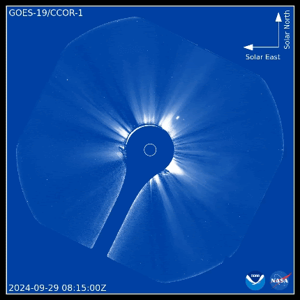
Both GOES-19 and the Space Weather Follow On at Lagrange 1 (SWFO-L1) carry sun-observing instruments such as the Compact Coronagraph (CCOR). CCOR provides operational monitoring of our sun to warn about its most energetic activity like coronal mass ejections (CMEs), shown below. CMEs pointed at Earth have caused the strongest space weather effects in recorded history; continued CME monitoring is essential to national security. NOAA has a series of three CCOR instruments: CCOR-1 is onboard GOES-19 in geostationary orbit, while CCOR-2 and -3 will settle at distant points out in deep space. NOAA will combine images from the three instruments to paint a more complete picture of CMEs, improving detection and increasing warning time.
Worldwide situational awareness
Weather is a powerful force on Earth. Harnessing NOAA satellite data makes the U.S. military powerful. Missions like GOES and JPSS collect data used for comprehensive planetary modeling and high-resolution focus. Looking outward, solar monitoring gives the U.S. military forewarning against threats to communications, navigation, and equipment. In addition to all the direct observations afforded by the many complementary instruments, NOAA’s archives, algorithms, and expertise are indispensable assets to military environmental intelligence.