
In recent years, droughts have become both more prevalent and severe, wreaking havoc in all 50 states and costing billions of dollars of damage with the heaviest impact to the mid-west, southwest and western regions.
NOAA's National Centers for Environmental Information (NCEI) which monitors and tracks severe weather and climate events dating back to 1980, have recorded 21 droughts in the past 23 years that have exceeded $1 billion in losses. NOAA and its interagency partners are committed to predicting and monitoring drought location, intensity and duration to mitigate such extensive losses. Emergency managers use data from NOAA’s Joint Polar Satellite System (JPSS) to plan, predict, and respond to dangerous drought conditions in the United States and throughout the world because of their global coverage.
The 2012 drought was the most severe drought in the United States since the 1930’s, with 80 percent of agricultural land experiencing drought conditions resulting in costly widespread harvest failure for corn, sorghum and soybean crops. 2013 was less severe yet caused $10 billion in damages and drought conditions have continued with historical severity. For instance, it affected the majority of California for all of 2014, making it the worst drought on record for the state. Surrounding states and parts of Texas, Oklahoma and Kansas also experienced severe drought conditions.
The damage from droughts also causes dry conditions that are prime for wildfires. Drought conditions have increased the quantity and magnitude of wildfires in western U.S. forests since the 1970s. The 2012 drought left dry ground conditions that combined with extreme heat and human error caused wildfires that devastated Colorado with fire sizes 1.5 times the 10-year average.
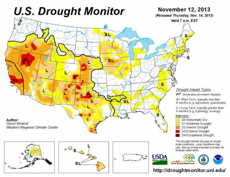
To help monitor and predict drought conditions, scientists will use a complement of JPSS land surface temperature, soil moisture and vegetation products derived from multiple instruments which are assimilated into the Global Land Data Assimilation System (GLDAS) and North America Land Data Assimilation System (NLDAS) systems. The NLDAS is the main information source for the current U.S. Drought Monitor.
“During eight of the last fifteen years large-scale droughts were responsible for huge losses of grain resulting in global production falling below steadily growing consumption,” said Felix Kogan, NOAA Environmental Monitoring Branch Research Scientist. “Since drought prediction is very challenging, drought monitoring and impact assessment are very important to address food security."
There are currently many drought detection and monitoring methods to include the U.S. Drought Monitor, which provide large-scale drought assessments, which media use in discussions of drought and policy makers can use in allocating drought relief. Consistent measurements of drought conditions provide the necessary environmental intelligence data needed to make accurate forecasts and educated decisions.
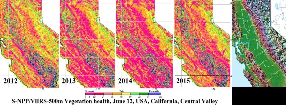
The 2015 drought affected large part of Central Valley, which is the principal agricultural area of California. The image above shows levels of vegetation health and stress in June of each year. The blue areas show where the vegetation is very healthy. These areas are agricultural farms in the central valley being supported by irrigation. The bright pink regions are where the vegetation is in extreme stress and/or the surface temperature is much higher than normal. The map on the far right is a false color topographic reference map, which clearly defines the central valley region. From the images, you can see the effect of late spring 2015 rains which temporarily improved the vegetation condition slightly when compared to June 2013 and June 2014.
Satellites have unique advantages over conventional observations of drought, due to their ability to acquire information over large geographical areas, measure and analyze key features of droughts routinely with relatively high repetition rates, and increased spatial detail of vegetation conditions.
The next-generation instruments aboard satellites in the JPSS constellation provide critical information for drought forecasts that assist in monitoring and predicting drought severity as well as wildfire conditions. Proper drought predictions and monitoring assist farmers in scheduling and maximizing crops, preparing for water conservation actions and securing a more "Weather-Ready Nation."
JPSS’ Visible Infrared Imaging Radiometer Suite (VIIRS) instrument will enable the monitoring of the Earth’s surface and its surrounding environment. These features in combination with new vegetation health methodologies provide highly valuable assessments of drought start and monitor drought area intensity, duration and impacts on agriculture, forestry, rangeland and other resources and activities. This is very important for such regions as California, where agricultural crops are irrigated. The image below demonstrates observation of changes in vegetation health during June 2015, the tenth year of mega-drought in the western U.S.
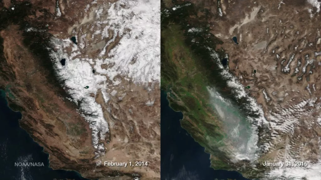
A series of atmospheric rivers in December 2014 brought much needed precipitation to a drought-stricken California. The result is a visibly greener land cover in early 2015 compared to the same time the previous year, as seen in these Suomi NPP satellite images. The state, however, is still in an extreme drought, having received very little rain or snow since. This lack of precipitation, along with warmer than normal temperatures, has resulted in much lower snowpack in the Sierra Nevada Mountains between the two years. Analysis by NOAA confirms that the extent and depth of the snowpack is much less in 2015 compared to 2014 along with higher snowpack temperatures (i.e, melting).
The VIIRS’ swath is 1.3 times wider than that of its operational predecessors, has a sharper view of the swath edge, excellent radiometric features, faster data processing and availability, higher resolution of 375m, and more satellite channels across the spectrum. VIIRS is able to provide vegetation health data, with eight times more detail, and at a much higher and more consistent quality. In addition, VIIRS provides multi-year services vital for land cover and climate change detection.
With extreme drought conditions expected to continue, JPSS data is vital for monitoring and understanding drought conditions, aiding forecaster’s ability to detect drought events earlier and predict intensity, duration and impacts. Earlier and more accurate predictions help Nation's leaders, decision makers, emergency managers and media to better provide increased warnings to the public-at-large.