

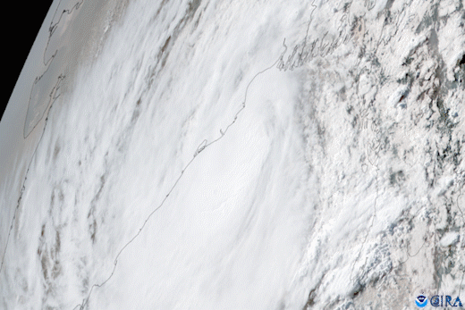
Japan's Himawari-8 satellite imagery from May 25-26 shows the Indian subcontinent over the course of 24 hours, with GeoColor vividly displaying the push of Yaas' cyclonic swirl. Over a week after Tropical Cyclone Tauktae made landfall on India's west coast, Tropical Cyclone Yaas battered the northeastern coastline of Odisha and Kolkata with flooding rain and sustained winds of 80-90 mph.
The power and projected path of the cyclone triggered the evacuation of roughly 1,000,000 people from areas in and around Jharkhand state. Ahead of Yaas' landfall, a tornado spawned in West Bengal's Hooghly district, killing two people. The rugged terrain of northern India, however, helped the storm rapidly drop from its peak intensity after it made landfall.
As of May 26, over 20,000 houses were destroyed, and Kolkata has ordered its regional airport closed. The military has been providing evacuation and relief for affected residents, as well as clearing roadways blocked by fallen debris. The impact of Cyclone Yaas, according to one top ministry official in a state news report, could be worse than Cyclone Amphan from last year.
This image was captured by the Advanced Himawari Imager (AHI) on Japan's Himawari-8 satellite. This satellite, the first unit of the Japan Meteorological Agency's (JMA) third-generation of geostationary satellites, provides visible light and infrared images of the Asia-Pacific region. Our satellite partnership with JMA is vital for global geostationary satellite coverage.