
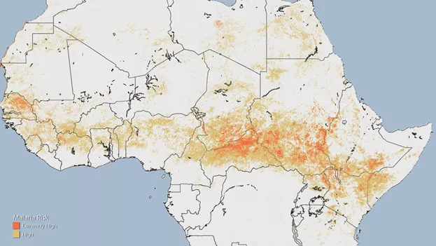
NOAA scientists are using data and imagery from polar-orbiting environmental satellites to predict malaria risk and save lives in Sub-Saharan Africa.
Mosquito nets, indoor insecticides, and drug treatments have traditionally been the go-to weapons in the fight against malaria. More recently, however, scientists have begun using satellite imagery, such as that produced by NOAA’s Polar Orbiting Satellites, to predict malaria risk and save lives in Sub-Saharan Africa.
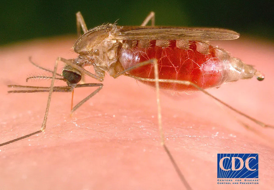
According to the World Health Organization, malaria is disease transmitted by the bites of infected female Anopheles mosquitoes. About 3.2 billion people are at risk of the disease, but one area in particular—Sub-Saharan Africa—bears a disproportionately high share of the world’s malaria burden. So far this year, the region has been home to 89 percent of malaria cases and 91 percent of malaria deaths. Young children and pregnant women are especially vulnerable and, according to some estimates, malaria claims the life of one child every 30 seconds.
Transmission of the disease is more intense in places where the mosquito lifespan is longer and where pests prefer to bite humans rather than other animals. The long lifespan of Africa’s Anopheles mosquitoes and their strong preference for biting humans is the main reason why nearly 90 percent of the world's malaria cases occur there.
Malaria transmission also depends on environmental factors such as rainfall, temperature, humidity, which affect mosquito survival. These factors are what allow satellites to play a role in predicting malaria risk.
You Can’t See Mosquitoes from Space
“I don't see mosquitoes from satellites, unfortunately, but I see the environment where mosquitoes are,” says Felix Kogan of the NOAA Satellite and Information Service in this video about his work. “Mosquitoes like warm and moist environments and this is what I see from the operational satellites."
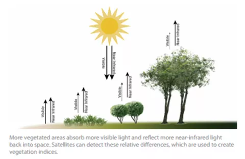
What Kogan sees, to be exact, is green vegetation on the landscape, which tells him that there is enough moisture and that the temperature is favorable to mosquitoes, allowing them to wreak their particular brand of havoc on the local population. If it’s too hot or too dry, mosquitoes will be less prevalent.
The vegetation imagery Kogan analyzes is created from data collected by NOAA’s Polar Orbiting Environmental Satellites, including NOAA 18 and 19. Since vegetated areas absorb more visible light and reflect more near-infrared light back into space, Kogan and his colleagues use the satellite’s radiation-detection imager— an instrument known as the Advanced Very High Resolution Radiometer or AVHRR— to measure changes to vegetation over time.
"Every week we receive satellite data ... and we convert them to our indices, which indicate if the surface is warm, if the surface is green enough, and has enough moisture,” said Kogan.
If conditions favorable to the mosquitoes are present, Kogan and his colleagues are able to predict— one to two months ahead of time—when, where, and how long the risk of contracting malaria will be highest.
Climate Constraints
Climate constrains the range of malaria and other vector-borne diseases, which are found mainly in tropical and subtropical countries and are relatively rare in temperate zones. However, climate models predict global average warming in the range of from 2 to 4 °C (2–8 °F) by 2100 —and rising temperatures may spread malaria (and other diseases) into areas where reports of infection have been relatively rare.
Moreover, it’s been said that warming temperatures (within their viable range) may boost mosquito reproduction rates, the number of blood meals they take, prolong their breeding season, and shorten the maturation period for the microbes they disperse. Rising temperatures could also increase the risk of flooding, which can trigger outbreaks by expanding vector (i.e. mosquito) ranges.
Fortunately, in addition to helping scientists keep tabs on vegetation, Suomi NPP will also help scientists monitor the Earth’s changing climate by gathering global measurements of atmospheric, terrestrial and oceanic conditions, including sea and land surface temperatures, vegetation, storm intensity, clouds, rainfall, and more.
For more about polar orbiting environmental satellites, visit the website of NOAA’s Office of Satellite and Product Operations.
To see the most recent maps of malaria risk in Sub-Saharan Africa, visit the website of NOAA's Center for Satellite Applications and Research.