
NOAA plans to include a hyperspectral infrared sounding instrument as part of the GeoXO satellite system. The GeoXO Sounder (GXS) will provide real-time information about the vertical distribution of atmospheric moisture, winds, and temperature. A sounder is a camera-like device whose detector is sensitive to numerous fine-scale ranges of infrared wavelengths, or bands. GXS will provide real-time data of the troposphere (the lowest level of the atmosphere where weather occurs), at a much higher frequency than current methods. It will be used for the estimation of temperature and humidity in the atmosphere by altitude, creating a profile of the atmosphere. The instrument will also provide estimates of the wind fields.
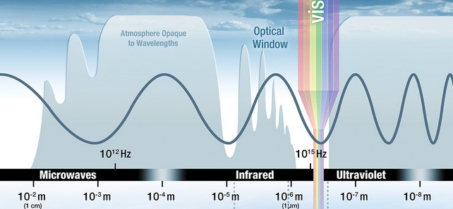
Infrared light lies between the visible and microwave portions of the electromagnetic spectrum and shows us how hot or cold things are, like layers of the atmosphere. It is not visible to the human eye. An infrared camera detects heat or thermal energy (by the atmosphere in this case) with a high degree of precision that detects temperature differences, that is, how much infrared light emitted by the ground and clouds reaches the sounder instead of being absorbed by carbon dioxide, water vapor and other atmospheric constituents along the way. The instrument converts that infrared reading into an electronic signal, processed into an image that our eyes can interpret. Different temperatures are assigned different brightness or false colors to them for easier interpretation.
Improvements Over Current Capabilities

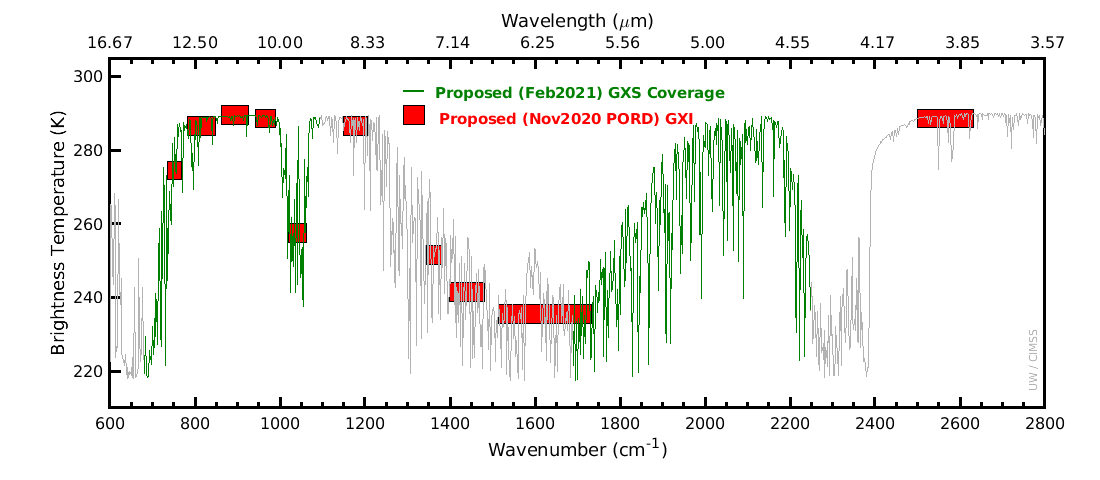
NOAA currently flies sounders on polar-orbiting satellites that orbit from pole to pole and fly over an area once a day. Those instruments don’t provide the nearly constant eye of geostationary spacecraft. Although NOAA flew multispectral sounders on an earlier generation of GOES satellites, the U.S. has not yet flown a hyperspectral infrared sounder in geostationary orbit. The legacy GOES sounders had only 18 spectral bands, while the next generation would have over 1,550 bands.
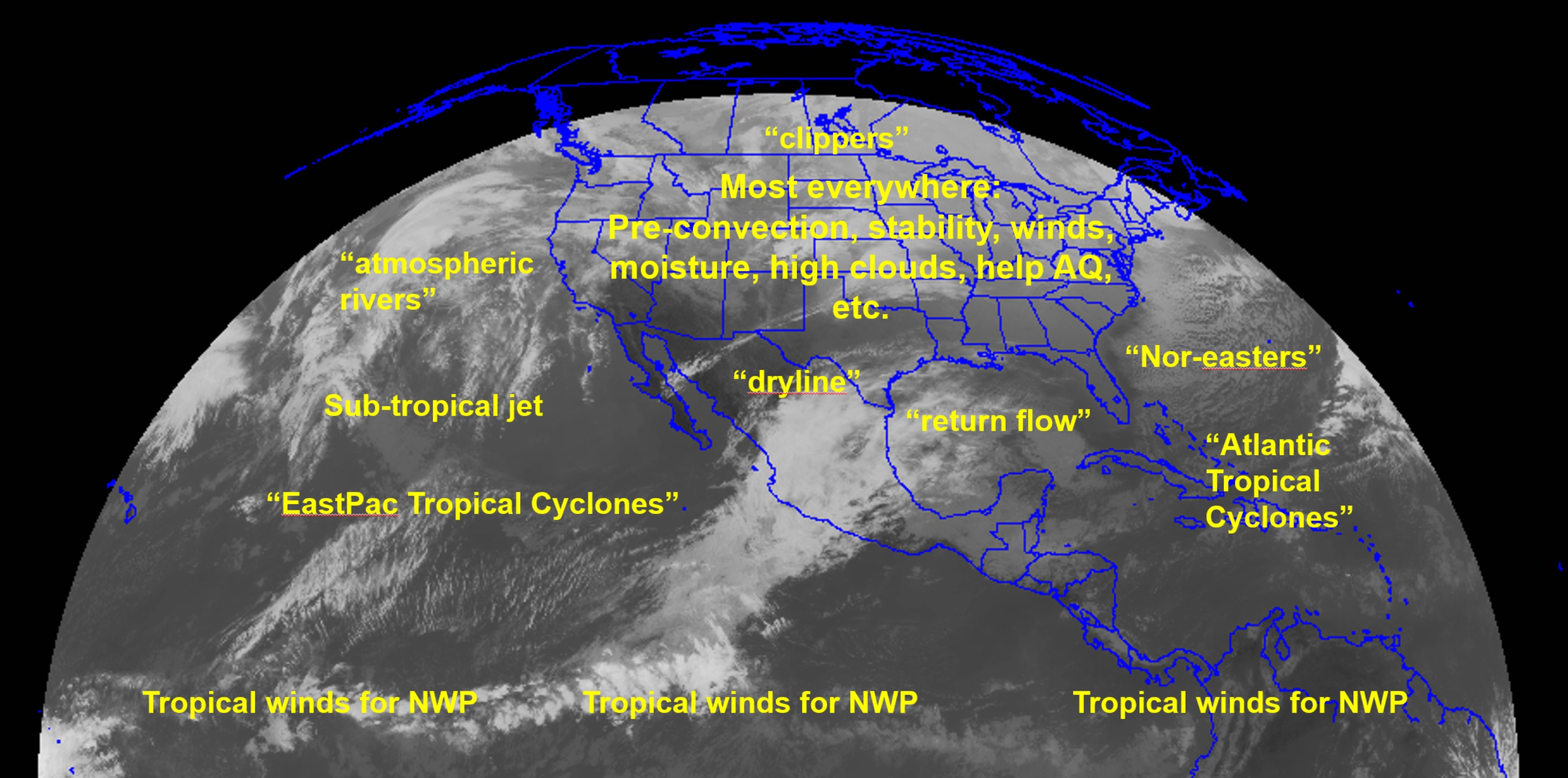
Obtaining temperature and humidity information about a column of the atmosphere from the tropopause to the surface from geostationary orbit would give forecasters insight into the behavior of the atmosphere where weather happens and help them make better forecasts. This includes estimates of atmospheric instability, to better forecast the locations of convection.
Benefits of a Geostationary Hyperspectral Infrared Sounder
Today, meteorologists and weather models rely on aircraft, weather balloons, and low-Earth-orbiting satellites. Aircraft and weather balloons are limited in areal extent and time. GXS will increase full atmosphere sensing over the United States by ten times compared to existing low-Earth-orbiting satellites, improving storm tracking and storm strength monitoring, and forecasting of fire behavior and smoke transport.
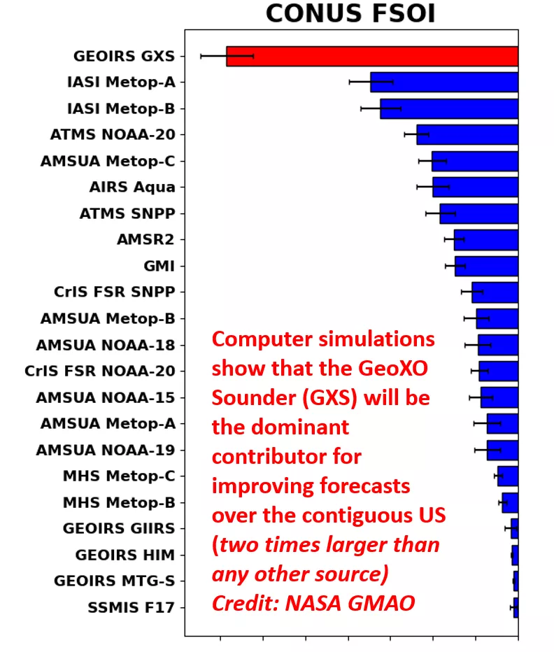
GXS data will feed advanced numerical weather prediction models and improve short-term severe weather forecasting. As weather disasters continue to worsen, investment in improved severe storm, tornado and hurricane forecasting and nowcasting is critical. Hourly sounding data from geostationary orbit is expected to reduce forecast error over the U.S., improve regional U.S. forecasting by up to 40%, and benefit global forecasting out to 2.5 days.
Better Convection Forecasts
GXS will measure vertical changes in temperature and moisture – seeing a profile of the atmosphere is the key to forecasting convection. The instrument will detect and track severe weather including flash floods and tornadoes as they form, and help forecasters give longer lead-time to warn residents to seek shelter.
Wind Velocity Determination
With temperature and humidity information, weather forecasters will have new insights into convection and precipitation. GXS data will enable monitoring of these factors over time and once included in forecast models, they could improve wind forecasts.
Improved Nowcasting
With scans every 30 minutes and at a higher resolution than current sounders, weather predictions could be delivered within a few hours of data collection.
Hurricane Forecast Improvements
During hurricane season, hurricane hunter aircraft use dropsondes, cylindrical instruments with parachutes that measure temperature and pressure as the instrument drops from the airplane to the surface. Aircraft can release dropsondes over an eight-plus hour flight. GXS will provide a near continuous profile of the atmosphere instead of at intervals, increasing understanding of how a tropical cyclone may move and strengthen or weaken. In fact, both hurricane track and intensity forecasts have been improved using GXS-like data over other parts of the globe.
Aviation Forecast Improvement
GXS will provide real-time monitoring and response to atmospheric conditions including icing possibilities, and wind speed and direction at different levels of the atmosphere, allowing airlines to better avoid costly turbulence. GXS can also detect wind shear, which can indicate turbulence for aircraft as well.
Severe Weather Predictions
GXS data will enhance weather forecast models to predict severe weather farther into the future than is currently possible.
Trace Gas Monitoring
GXS will help monitor several critical trace gases to improve human health. These include at least: ozone, ammonia, nitrous oxide, and carbon monoxide.
GXS Value Assessment Report
Learn more about the benefits of geostationary hyperspectral infrared sounding observations in NOAA’s Technical Report: Geostationary Extended Observations (GeoXO) Hyperspectral InfraRed Sounder Value Assessment Report
GXS Status
On September 11, 2023, NASA selected Ball Aerospace & Technologies Corporation of Boulder, Colorado, to develop NOAA’s GeoXO Sounder. The contract includes the development of one flight instrument as well as options for additional units. The contract scope includes the tasks and deliverables necessary to design, analyze, develop, fabricate, integrate, test, verify, evaluate, support launch, supply and maintain the instrument ground support equipment, and support mission operations at the NOAA Satellite Operations Facility.
Related Links
- Suomi NPP Visible Infrared Imaging Radiometer Suite (VIIRS)
- NOAA-20 Visible Infrared Imaging Radiometer Suite (VIIRS)
- JPSS-2 Visible Infrared Imaging Radiometer Suite (VIIRS)
- JPSS-2 Understanding Infrared Light teaching activity
- Geostationary Hyperspectral IR Sounder SSEC webpage
The information on this page is subject to change as the GeoXO program develops.