
At any given time, tens of thousands of vessels are navigating our oceans, from massive cargo ships and oil tankers to military fleets and cruise liners, with global shipping transporting 80% of the world’s goods and driving an industry valued at $2.3 trillion annually. However, with increasing traffic comes heightened risk—severe storms, high winds, and rogue waves pose significant threats to vessels, crews, and passengers. Ensuring safe passage across unpredictable waters requires accurate marine forecasting, which is where low Earth orbit (LEO) satellite observations play a vital role.
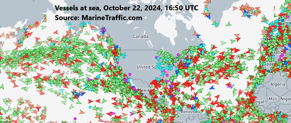
Vessels at sea on October 22, 2024, at 16:50 UTC. Source: MarineTraffic.com.
The National Weather Service (NWS) Ocean Prediction Center (OPC) relies on a suite of forecasting tools, including LEO and geostationary (GEO) satellite data, to track hazardous marine weather. LEO missions, such as the NOAA/NASA Joint Polar Satellite System (JPSS), offer a unique advantage in tracking storm systems over the open ocean, where surface observations are limited—especially at higher latitudes, thanks to their polar orbits. These satellites capture critical data on global ocean winds, sea ice, and atmospheric changes, enhancing marine forecasts in even the most remote regions. Leveraging these and other observations, OPC meteorologists work around the clock during peak storm seasons to issue forecasts, guidance, and marine warnings—averaging 12,700 warnings per year—up to five days in advance, with more than 100 products issued daily. These timely alerts help mariners make critical decisions, such as adjusting their course, delaying departures, or seeking safer waters.
“Scatterometer data [from LEO satellites] is probably one of the most important tools that we have at the Ocean Prediction Center,” said Michael Folmer, PhD, Warning Coordination Meteorologist at the NWS OPC, at a LEO Science Seminar. Scatterometers, such as the Advanced Scatterometer (ASCAT) aboard European Metop satellites, measure ocean wind speed and direction by sending microwave pulses toward the ocean surface and analyzing the returning signal. Stronger winds create rougher seas, resulting in more radiation bouncing back to the instrument. “Scatterometer data, when it’s timely, can really help us gain confidence in whatever the situation may be,” Folmer explained. In one case, an unexpected storm off the U.S. West Coast intensified beyond model predictions, but timely ASCAT wind data revealed critical details that other observations and forecasts had missed. This additional information allowed OPC to upgrade its storm warning to hurricane-force conditions, giving ships crucial time to adjust their routes. Real-time satellite insights like these can mean the difference between a routine voyage and a life-threatening situation at sea.
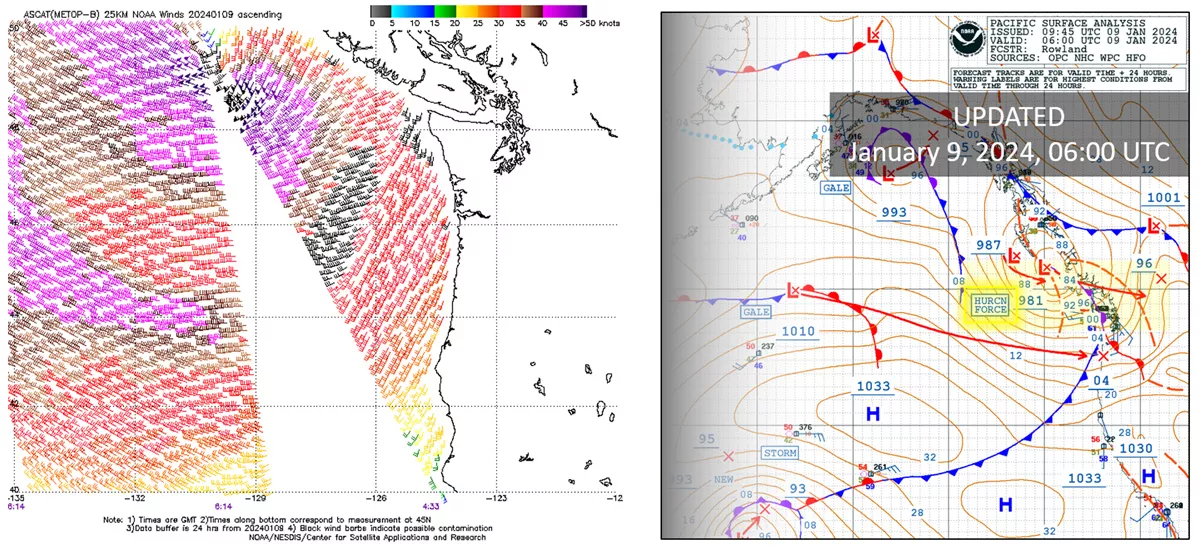
Left: ASCAT ocean wind data from January 9, 2024, detected hurricane-force winds near the edge of the satellite pass, shown by dark purple barbs with triangle flags, west of Vancouver Island, Canada. ASCAT wind products are processed by NOAA NESDIS Center for Satellite Applications and Research (STAR). Right: With this additional ASCAT data, the OPC upgraded its storm classification from “storm force” to “hurricane force” in its Pacific Analysis product.
The importance of accurate maritime forecasting extends beyond immediate safety—it also ensures the smooth operation of global shipping lanes. A single miscalculated storm can delay shipments, disrupt supply chains, and result in substantial financial losses. As the OPC refines its storm prediction models and new LEO satellites, such as NOAA’s next-generation Near Earth Orbit Network (NEON), come online, mariners will have even more advanced tools to navigate hazardous waters—helping safeguard vessels, cargo, and lives amid the ever-changing conditions of the open ocean. To learn more about the NWS Ocean Prediction Center’s operations, explore The Role of LEO Observations in Forecasting Rapidly Changing Conditions for Maritime Safety in the newly released 2024 LEO Science Digest.