
Revealing the Night Sky: Detecting Natural Gas Flares With the Visible Infrared Imaging Radiometer Suite (VIIRS)

April 1, 2024
The image depicts an oil field at dusk, characterized by a large, controlled burn-off flame from a gas flare. In the background, an oil pump jack is silhouetted against the fading light of the day. The sky is a muted blue and the ground is bare, brown soil. Storage tanks and additional infrastructure are visible in the midground.
A flare stack at a wellhead. Source: South Coast Air Quality Management District

Flaring is a method used in the oil industry to burn off natural gas that is a byproduct of oil extraction. This practice, which dates back to the mid-1800s, is commonly used at oil fields as a relatively safe way to depressurize oil extraction equipment. However, flaring releases significant quantities of methane—a potent greenhouse gas—along with other pollutants. Every year, around 10,000 flares at oil sites worldwide burn approximately 140 billion cubic meters of natural gas. Current estimates indicate this volume results in more than 350 million metric tons of carbon dioxide equivalent (CO2e) emissions each year. Keeping an eye on this flaring activity is essential.

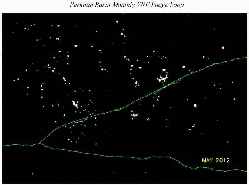
Satellites have played a crucial role in monitoring flares since as early as 1978. By using different spectral bands, satellite sensors like the JPSS Visible Infrared Imaging Radiometer Suite (VIIRS) can identify and analyze the characteristics of individual gas flares, such as intensity, duration, and location. Exploiting these capabilities, Dr. Christopher Elvidge and his team at the Earth Observation Group at the Colorado School of Mines have developed a product called VIIRS Nightfire. The tool uses multispectral VIIRS imagery to report on temperature, source size, and the radiant heat of natural gas flares, aiding in annual global surveys of flaring sites.

This image is a composite night-time view of the Earth from space, showing various sources of light. The continents are outlined with the lights of cities and towns, and the vast darkness of the oceans contrasts with the illuminated areas. Red dots indicate natural gas flares, gold dots indicate artificial light, and white dots indicate boat detections.
This map displays nighttime multiband observations from the Visible Infrared Imaging Radiometer Suite (VIIRS), revealing various human activities visible from space, such as city lights, fishing boats, marine transportation, and combustion sources like natural gas flares, wildfires, and industrial activities. It is compiled using annual data from three VIIRS products developed by the Earth Observation Group: VIIRS Nightfire (2017) shown in red, VIIRS Nighttime Lights (2015) in gold, and VIIRS Boat Detections (2017) in white. Source: Earth Observation Group (EOG) / Payne Institute of Public Policy, Colorado School of Mines.

Gas flares generate intense heat, with typical radiant emissions reaching between 1500 to 2000 Kelvin (2240-3140°F). Infrared signals from natural gas flares correspond well to the nighttime detection capabilities of VIIRS’s near-infrared and shortwave infrared bands. These capabilities are illustrated below in VIIRS nighttime imagery of Basra, Iraq, where gas flares stand out as bright white dots isolated against the dark sky in near-infrared images (Bands M7 and M8) and shortwave infrared images (Bands M10 and M11). Flares are also detectable in VIIRS nighttime visible imagery from the Day/Night Band (DNB) and in mid-wave and longwave infrared imagery (Bands M12-16). However, distinguishing flares from other sources of emitted radiance in these bands can be challenging due to the blending of light sources. The VIIRS Nightfire product uses a combination of these spectral ranges to detect and characterize gas flare activity.

The image shows a series of nighttime satellite images of Basra, Iraq, taken on March 22, 2018, across various VIIRS spectral bands. From left to right and top to bottom, they are: DNB (Day/Night Band) - Visible (VIS) light, 0.7 μm wavelength; M7 (Band 7) - Near-Infrared (NIR), 0.865 μm; M8 (Band 8) - NIR, 1.24 μm; M10 (Band 10) - Short-Wave Infrared (SWIR), 1.61 μm; M11 (Band 11) - SWIR, 2.26 μm; M12 (Band 12) - Mid-Wave Infrared (MWIR), 3.7 μm; M13 (Band 13) - MWIR, 4.05 μm; M14 (Band 14) - Long-Wave Infr
These nighttime VIIRS images show natural gas flares in Basra, Iraq on March 22, 2018. The VIIRS Day/Night Band (DNB), upper left, detects multiple light sources, including city lights, wildfires, and gas flares. VIIRS effectively identifies and isolates natural gas flare sources under nighttime conditions using its near infrared (NIR) and shortwave infrared (SWIR) M-Bands, as highlighted by the bright white dots observed in M-Bands 7, 8, 10, and 11. Flares can also be seen, although less so, in mid-wave infrared (MWIR) M-Bands 12 and 13. However, flares are almost undetectable in longwave infrared (LWIR) M-Bands 14, 15, and 16 due to the blending of other radiance emitted by the Earth. Source: Dr. Christopher D. Elvidge.

The Earth Observation Group processes approximately 450 gigabytes of VIIRS nighttime data daily from three JPSS satellites—Suomi NPP, NOAA-20, and NOAA-21—facilitating the global monitoring of natural gas flare activity through the VIIRS Nighttime product. With records dating back to 2012, this initiative provides a detailed and long-term dataset on global flaring activities, supporting nuanced analysis and historical evaluations in the environmental and energy sectors. Available on the group’s website, these data resources empower researchers, industry experts, and regulatory agencies to assess the environmental impacts of gas flaring, ensure regulatory compliance, and strategize on emission reduction.

This animation loop shows monthly detections of natural gas flares in the Permian Basin from 2012 to 2022 from the VIIRS Nightfire product. The animation shows an increase in flare activity over the specified period.
This animation loop shows monthly detections of natural gas flares from VIIRS Nightfire in the Permian Basin from 2012 to 2022. The Permian basin, a large sedimentary basin in the southwestern region of the U.S., is the highest producing oil field in the country. The animation shows an increase in flare activity over the specified period. Source: Earth Observation Group.
Magazine cover image with a image of the Earth with 3 satellites orbiting in a polar orbit.

Explore the 2023 JPSS Annual Science Digest to learn more about the importance of monitoring natural gas flares, the science behind the VIIRS Nightfire product, and how scientists and others use the tool to detect flares and other combustion sources. The JPSS Annual Science Digest offers an in-depth look into many JPSS products, innovative applications of JPSS data, and the benefit of JPSS to society.