
On Feb. 9, an ozone-measuring instrument on the NOAA-21 satellite opened its doors and, about a week later, captured its first global image since the satellite's Nov. 10 launch. The Ozone Mapping and Profiler Suite (OMPS) consists of a set of three sensors that are vital for monitoring the Earth's ozone layer and tracking its recovery as the amounts of atmospheric ozone-depleting chemicals decline.
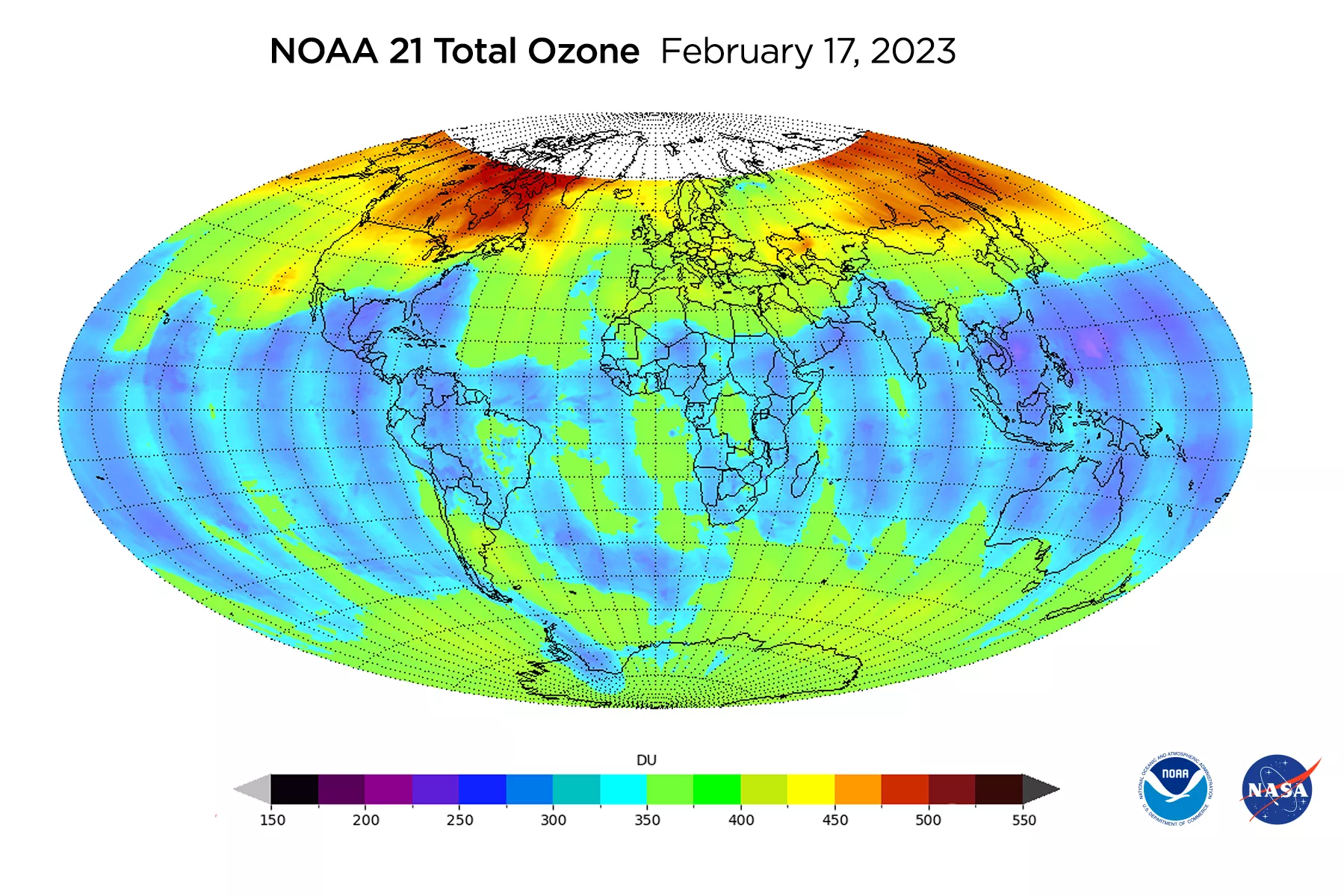
The top image shows total ozone in the atmosphere distributed across the globe. Higher ozone levels are concentrated near the North Pole, which is typical for this time of year.

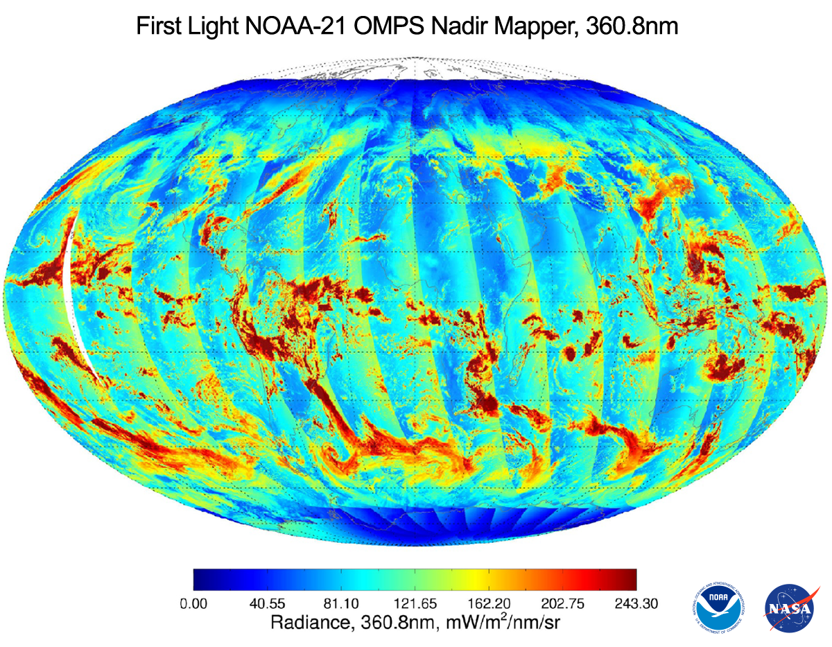
The image above (Figure 2) shows a global mosaic of observations, taken on February 17 by the instrument’s Nadir Mapper. The highest radiances are associated with bright cloud tops. The cloud reflectivity channel is one of the five primary channels used to estimate total ozone concentration.
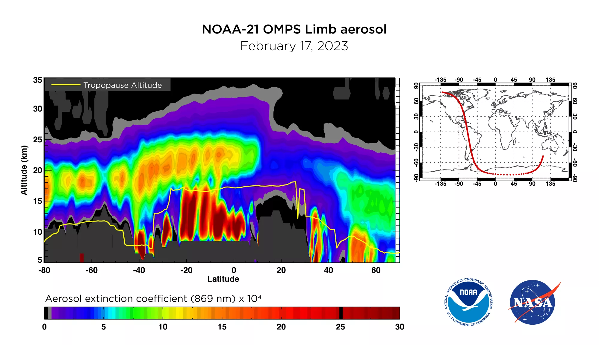
On the same day, NOAA-21’s OMPS also detected volcanic aerosols left over from the massive Hunga Tonga underwater volcano that began powerfully erupting in the South Pacific a year ago, spewing water vapor and sulfur dioxide into the stratosphere (See Figure 3).
OMPS was originally designed to measure ozone high in the atmosphere, which protects humans and other life on Earth from the harmful effects of ultraviolet radiation.
“The goal was to be able to really make very precise measurements of ozone over long timescales,” said Glen Jaross, the OMPS instrument scientist for NOAA’s Joint Polar Satellite System (JPSS). “We want to be able to measure ozone changes to a percent or better over a 10-year timescale.”
Over time, the OMPS instrument’s capabilities have expanded to include other aerosols, such as smoke from wildfires and sulfur dioxide and ash from volcanoes
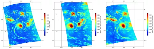
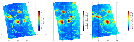
OMPS can also capture the cloud structure of severe weather events. The three images above (Figure 4), were taken on February 18, 2023, over a tropical storm in the Indian Ocean. The image on the left is from NOAA-21’s OMPS instrument and the picture on the right is from OMPS on NOAA-20. The cloud structure is more clearly visible from OMPS on the NOAA-21 satellite compared to those from NOAA-20 and Suomi NPP. This is due to the improved spatial resolution of the latest instrument.
NASA began measuring ozone from space in 1970, not long before scientists discovered that harmful chemicals called chlorofluorocarbons, or CFCs, result in a dangerous depletion of atmospheric ozone. By the mid-1980s, scientists discovered a hole in ozone in the stratosphere over the Antarctic. A global effort to ban these gases has resulted in the stabilization of ozone levels over the past three decades, with recent measurements indicating ozone levels are beginning to increase.
OMPS instruments, which also fly on NOAA-21’s sister satellites, NOAA’s Joint Polar Satellite System’s NOAA-20 and Suomi-NPP, along with an instrument aboard the Aura satellite, showed that between Sept. 7, 2022, and Oct. 13, 2022, the Antarctic ozone hole had reached an average area of 8.9 million square miles, an area slightly smaller than last year, continuing a shrinking trend.
Last week, engineers sent a command to OMPS, directing a mechanism to open the nadir and limb sensor doors, according to Natalie Ciampa, the OMPS instrument manager for JPSS. This allowed the instrument to start collecting data.
OMPS detects what’s known as “backscattered” light from the atmosphere. That’s sunlight that reflects off either the atmosphere or the Earth’s surface. OMPS does this by looking at the sun and measuring the direct solar signal and then turning to Earth to measure the fraction of that signal that gets reflected back.
Think of the Earth as a laser shining on a disco ball, Jaross said. The sun is like a laser, and all the sparkles are light reflected off the Earth. “And OMPS is sitting out there, and it’s picking up all that light.”
OMPS measures atmospheric ozone in two ways, by mapping total ozone over the globe using the Nadir Mapper, and by probing the atmosphere vertically to collect precise measurements at different altitudes using the Nadir Profiler and the Limb Profiler. The suite’s nadir instrument (NM), operated by NOAA, points directly down at Earth, and the limb instrument (LP), operated by NASA, measures from an angle. And this latest version on NOAA-21 has some improvements.
The spatial resolution on NOAA-21's OMPS mapping instrument has improved. While the nadir footprint of the Suomi-NPP satellite was about 30 by 30 miles, the resolution on NOAA-21 OMPS can now measure about 6 by 6 miles. The latest instrument also provides the capability to measure nitrogen dioxide, a precursor to ground-level ozone, the primary ingredient in smog. This is not to be confused with stratospheric ozone high in the atmosphere that protects humans and other life against ultraviolet rays.
“Quantifying these atmospheric species is important for a variety of reasons, including monitoring the ozone layer and its interactions with climate change, tracking volcanic sulfur dioxide and ash for air traffic safety, and identifying pollution sources and levels for general air quality health assessments,” said JPSS Program Scientist Satya Kalluri.
Together, NOAA and NASA oversee the development, launch, testing, and operation of all the satellites in the Joint Polar Satellite System program. NOAA funds and manages the program, operations, and data products. On behalf of NOAA, NASA develops and builds the instruments, spacecraft, and ground system, and launches the satellites, which NOAA operates.