
Tomorrow, March 20, researchers at the U.S. Amundsen-Scott South Pole Station in Antarctica will watch the sun set for the last time until it rises again around the time of the autumnal equinox. In this part of the world, days and nights last half a year.
The coldest, driest, windiest place on Earth, these extended periods of daylight and darkness correspond with the continent’s two seasons: summer and winter. The amount of darkness in the winter and daylight in the summer increases as you move closer to the poles due to the tilt of the Earth’s axis in relation to the Sun. When the South Pole is pointing toward the Sun in the summer, the Sun doesn’t set. Similarly, when it is pointing away from the Sun in the winter, the Sun doesn’t rise.
Additionally, the long days and nights pair with the near-constant cold. The average monthly summer temperature at the station is about −18°F, and the average monthly winter temperature is about −76°F, according to the U.S. Antarctic Program. The lowest temperature ever recorded in Antarctica was −89.4°C (−129°F). The highest temperature ever recorded in Antarctica was 15°C (59°F).
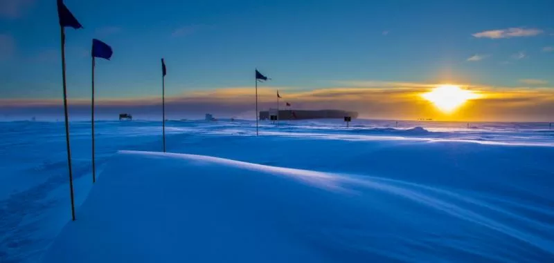
The National Science Foundation's Atmospheric Research Observatory illuminated by the Sun approaching South Pole sunset in 2014. (NOAA-LT Joseph Phillips)
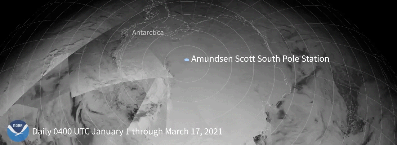
In order to watch the daily progression of the line that separates day from night—otherwise known as the day/night terminator —the composite image at the top of this article was created from geostationary satellite data with supplemental information from polar-orbiting satellites operating during a similar timeframe. Since geostationary satellites orbit more than 22,000 miles and are set to focus on the Earth’s equator, they don’t have an ideal view of the poles. To remedy this, scientists also use data from polar-orbiting satellites that are only 500 miles away and can get a better view of the area.After the data was processed, imagery collected at the same time (0400 UTC/12:00 a.m. EDT) each day over the course of several weeks was combined to create the loop you see above.
While polar-orbiting satellites orbit closer to the Earth, they collect physical information in high-resolution scans, called swaths, as they pass by. These are then combined with the other imagery, which is why you can see lines where the swaths were digitally stitched together. The angle of the sun affects the lower-orbiting polar satellite's imagery much more, since the sun glint is nearer to the lens and shows up more brightly than they would on a lens positioned further away.
The distance from Amundsen-Scott South Pole Station to Ushuaia, Argentina—the nearest large city, very close to the southernmost point of South America—is nearly 2,500 miles. A photo of the South Pole Station is taken every 15 minutes by a live web camera. View the most recent image online.
The University of Wisconsin's Space Science and Engineering Center (SSEC) partners with NOAA to supply imagery of the difficult-to-visualize North and South Poles.