
For months, we've been saying that GOES-16, NOAA’s most advanced geostationary weather satellite to-date, will usher in an era of new weather forecasting possibilities. This animation demonstrating the amazing capabilities of the satellite's Advanced Baseline Imager (ABI) shows how.
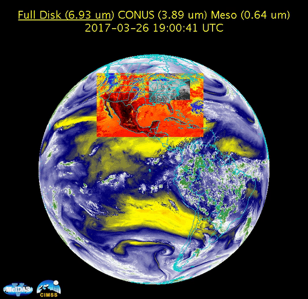
GOES-16's Advanced Baseline Imager (ABI) will be a boon for forecasters because it can scan three types of sectors simultaneously: the entire Western Hemisphere every 15 minutes, the contiguous United States every 5 minutes, and smaller mesoscale sectors that can be moved over regions of interest (e.g., areas of severe weather or other rapidly changing phenomena) every 60 seconds. Even better, if the mesoscale sectors are programmed to scan over the same area, they can provide imagery of severe weather as often as every 30 seconds!
This is a great improvement over the current GOES satellites (i.e., GOES-13, -14 and -15) as ABI's enhanced scanning capabilities will allow meteorologists to locate and analyze atmospheric or meteorological phenomena in near-real time. Further, when coupled with the imager's improved resolution, which is four times better than that of its predecessors, these scans will not only be more frequent, but more detailed as well.
But wait, there's more! Beyond the direct use of this near-real-time imagery, the expanded capabilities of the Advanced Baseline Imager are likely to lead to improved quantitative data products pertaining to important meteorological parameters, including as cloud properties, atmospheric motion, dust, hurricane intensity, rainfall, and volcanic ash.
To see additional images and animations from GOES-16 on the NESDIS website.
Please note: GOES-16 data are currently experimental and under-going testing and hence should not be used operationally.