
The National Oceanic and Atmospheric Administration (NOAA) is committed to supporting emergency management in order to improve the nation's capability to prepare for, protect against, respond to, recover from, and adapt to natural and man-made hazards. IAEM is a chief partner in helping NOAA determine how to best utilize its resources to accomplish that goal. Shared below are some of the great resources NOAA can provide:
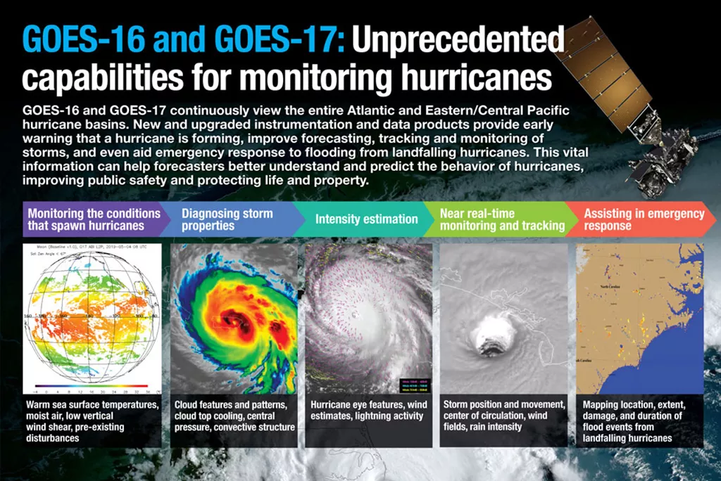
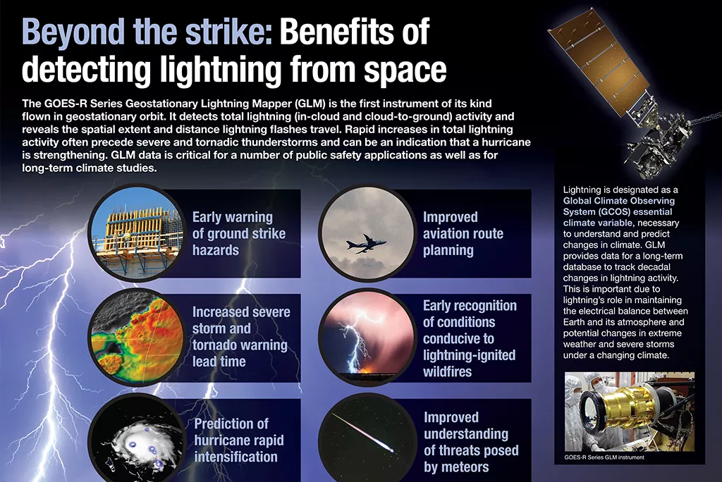
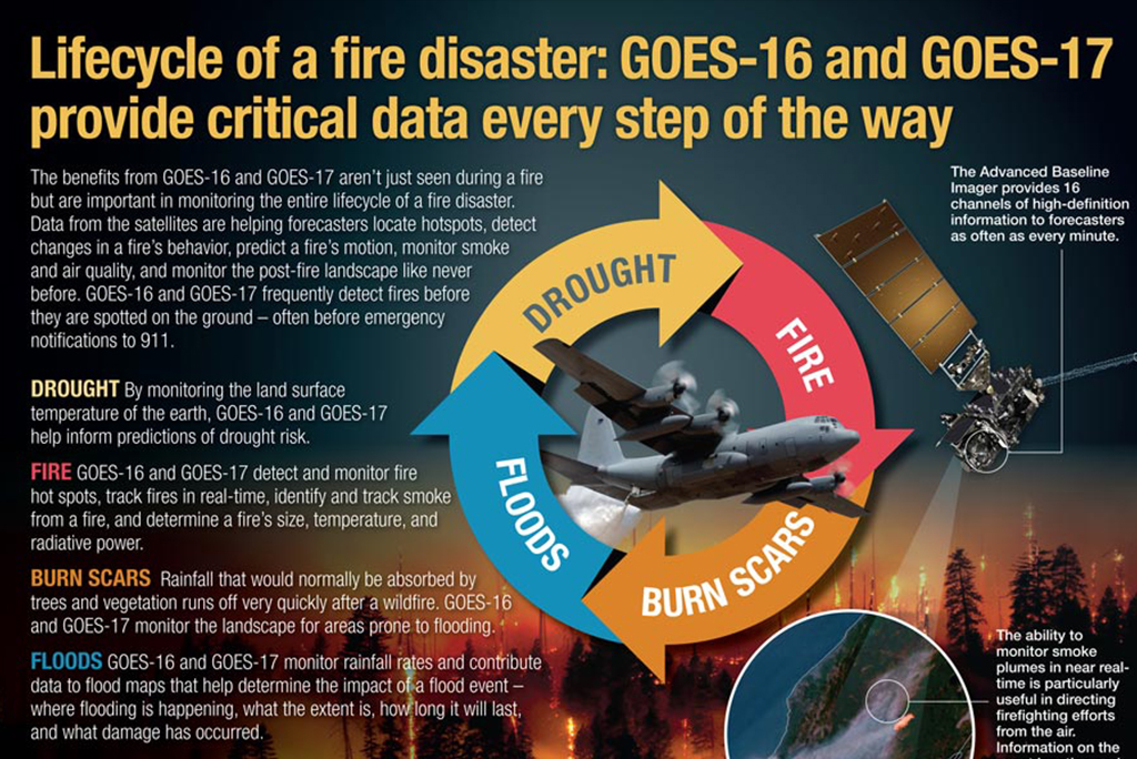
NOAA’s National Environmental Satellite, Data, and Information Service (NESDIS)provides imagery and information that emergency managers use in their decision-making. Every minute of the day, NESDIS experts use satellites, ground stations, computers and processing systems to provide observations and critical expertise to our partners when they need them. It’s important to note that NESDIS staff are not the first responders, or those issuing forecasts, but have always been considered the first informers.
The NOAA Direct Broadcast Real Time Network provides a faster way for meteorology agencies like the National Weather Service to get access to satellite data for rapidly updating forecast models. Through the Direct Broadcast network, antenna sites across the U.S. acquire and process satellite data in real time, making it available for weather forecasting models in less time than traditional methods. Direct Broadcast has enabled significant improvements in forecasting capabilities for the Rapid Refresh (RAP) and High-Resolution Rapid Refresh (HRRR) models, which serve a variety of purposes, including notifying people downwind of a fire about the smoke-related hazards headed their way. Direct Broadcast in overseas locations like Puerto Rico and Guam have provided invaluable satellite data to these remote locations, allowing them to access rapidly changing weather conditions to help save lives and property.


NOAA’s National Ocean Service (NOS)provides expertise and services to inform and assist disaster response, especially along the coast. NOS is committed to improving the nation’s capability to prepare for, protect against, respond to, recover from, and adapt to natural and human-caused hazards.
In 2015, FEMA approved six NOS Pre-Scripted Mission Assignments (PSMAs) including coastal advisors, aerial imagery, hydrographic services, geodetic surveys, oil and chemical spill response, and marine debris assessment. Detailed information about the NOS PSMAs can be found in the Services in Support of Disaster Response: Expertise and Capabilities of NOAA’s National Ocean Service brochure.
In addition, NOS provides a suite of online products designed to assist emergency managers at all levels effectively assess and manage the situation. These products include the Computer-Aided Management of Emergency Operations (CAMEO), General NOAA Operational Modeling Environment (GNOME), Environmental Response Management Application (ERMA), Environmental Sensitivity Index (ESI) Maps, Digital Coast, Storm QuickLook, Physical Oceanographic Real-Time System (PORTS®), and the Integrated Ocean Observing System (IOOS®).

NOAA responded to the New Carissa oil spill in 2012 off the Oregon Coast
In order to build a Weather-Ready Nation ,NOAA’s National Weather Service(NWS) works closely with federal, state, tribal, territorial, and local emergency managers to provide support for responding to extreme weather and flood events. This is primarily achieved through NWS’ Weather Forecast Offices and River Forecast Centers providing localized forecast information and Impact-based Decision Support Services, or IDSS , remotely and in-person to Emergency Operations Centers and incident management teams.
NWS’ National Centers , including the National Water Center and Tsunami Warning Centers , provide predictions, data and tools for a variety of natural hazards that impact the U.S. They work closely with our Weather Forecast Offices and River Forecast Centers to ensure emergency managers are able to leverage all of NOAA’s resources in their decision-making.
Emergency managers are encouraged to establish working relationships with their local NWS offices in support of their operations including exercises. Your Warning Coordination Meteorologist is your local liaison for NWS.
NWS operational support to emergency managers through its IDSS.
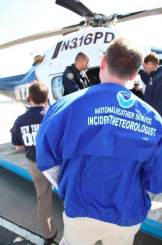
NOAA’s Office of Marine and Aviation Operations (OMAO)manages and operates NOAA's fleet of 16 research and survey ships and nine aircraft, including the invaluable Hurricane Hunters. The fleet supports a wide range of marine activities including fisheries research, nautical charting, and ocean and climate studies. In addition to research and monitoring activities critical to NOAA’s mission, OMAO ships and aircraft provide immediate response capabilities for extreme storms. Following hurricanes, NOAA ships conduct emergency surveys for navigation hazards that help ports reopen quickly. Aerial images of disaster-torn areas - taken by NOAA aircraft - enable residents and emergency workers to verify the condition of houses, bridges and roads.
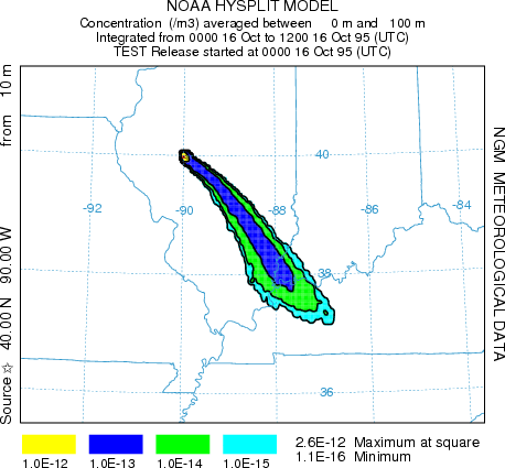
NOAA’s Oceanic and Atmospheric Research (OAR)- or "NOAA Research" - provides the research foundation for understanding the complex systems that support our planet. The programs at NOAA Research enable better forecasts, earlier warnings for natural disasters, and a greater understanding of the Earth. Research results allow decision makers such as emergency managers to make effective judgments in order to prevent the loss of human life. An example is the HYSPLIT transport and dispersion model.
The OAR’s Weather Program Office works closely with the NWS to help develop and transition weather research, including hurricanes, severe thunderstorms, heavy precipitation, and air pollution. Social science is utilized to understand how to deal with the uncertainties weather presents and to inform risk communication. They administer research grants in support of the NOAA goal of building a Weather-Ready Nation.
Sea Grant helps emergency management professionals implement many risk communication and resilience planning results from NOAA Research. Examples include oil spill response readiness reports, storm/risk assessments that guide communication efforts, and planning tools like the Coastal Community Resilience Index that brings together elected officials, public works directors, emergency managers, and other leaders at the community-government level to take an in-depth look at their community’s level of resilience.
The NOAA HYSPLIT model can provide plume dispersion results in minutes to first responders
NOAA’s National Marine Fisheries Service (NMFS)is responsible for the stewardship of the nation's ocean resources and their habitat. NMFS provides vital services for the nation: productive and sustainable fisheries, safe sources of seafood, the recovery and conservation of protected resources, and healthy ecosystems.
NMFS experts can be utilized by emergency management when responding to a disaster that has had consequences on marine species. Natural or man-made disasters could result in mass mortalities, injuries, or illnesses to marine animal populations; damage to marine habitats; or affect food safety and public health. Leveraging volunteer networks, NMFS can support these unique responses in a timely manner.
NMFS also works closely with state officials when governors request help with fishery disaster recovery following flooding and other hazards that impact the industry. Long-term flooding from the Mississippi River in 2018 had significant impacts on the Louisiana crab and shrimp industry and NOAA recommended, and the Commerce Secretary approved, a fishery disaster due to those impacts.
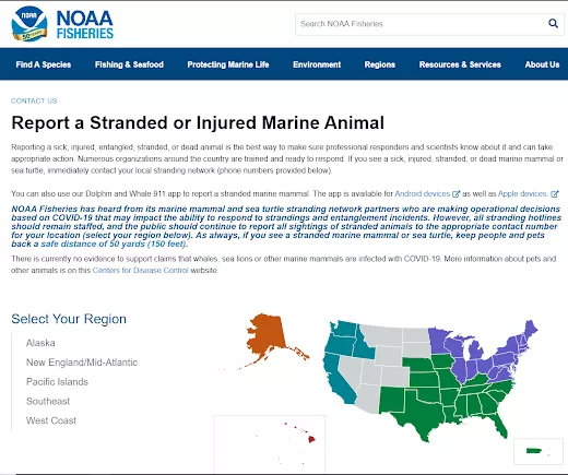
NOAA NMFS and its partners provide a network for reporting stranded or injured marine animals.