
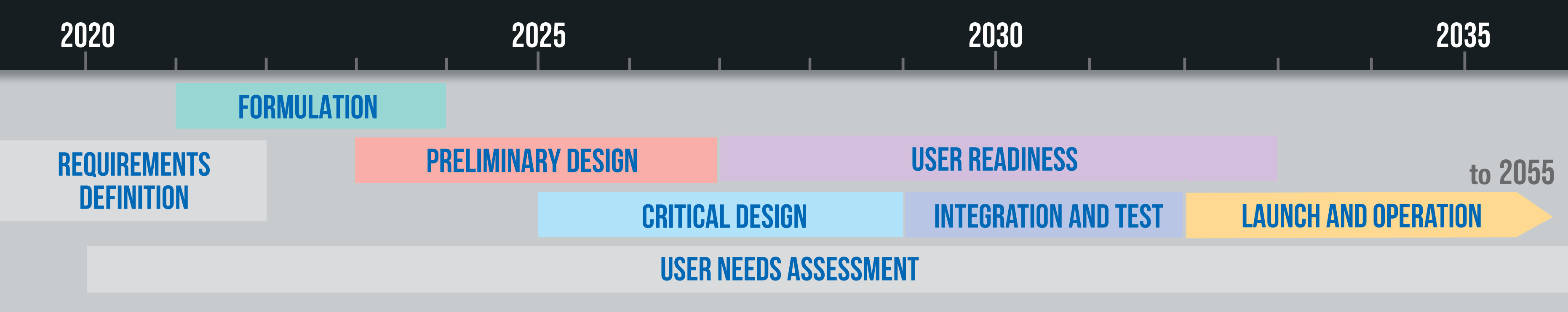
NOAA assessed user needs and studied a variety of potential observational capabilities for the GeoXO system. These analyses informed key decisions and helped define instrument, spacecraft, and system requirements. Formulation is underway, which will lead to the preliminary design of the spacecraft and instruments. As the program moves into the critical design stage, NOAA will begin preparing data users for new capabilities the GeoXO system will provide. The first GeoXO launch is planned for 2032 and the mission will maintain and advance NOAA’s geostationary observations through 2055.
NOAA began defining instrument, spacecraft, and system requirements for GeoXO in 2019. The NOAA Satellite Observing Systems Architecture (NSOSA) study, Geostationary Orbit Concept Exploration (GEO) broad agency announcement studies by industry, government instrument and constellation studies, and engagement with satellite data users to assess their needs helped refine requirements.
During formulation, a clear vision is developed of the program’s benefits and usage in the operational era. During this phase, the program demonstrates that the mission is able to meet goals and objectives.
The GeoXO Program was formally approved to begin the technology and development phase of the mission in July 2021, and in November 2021 the program was formally initiated. During formulation, the team is refining mission requirements, detailing acquisition strategies, schedules, cost estimates, resource planning, and risk management, and confirming technology readiness.
The program began collaborating with industry partners on Phase A Studies for the spacecraft and each of the instruments in 2020. These definition-phase study contracts are helping to design the instrument and spacecraft concepts, mature necessary technologies, and define potential performance, risks, costs, and development schedules. The results of the studies will be used to set performance requirements for implementation contracts. Implementation contracts will be awarded in 2023 and 2024.
Following a successful System Requirements Review on Aug. 25, 2022, the defined GeoXO requirements and preliminary program plan were approved and confirmed to meet the needs of the mission.
On Dec. 14, 2022, the Department of Commerce officially approved the GeoXO Program, following the Milestone 2 Review. GeoXO can now proceed into the development phase of the mission.
During the preliminary design phase, the program will complete technology development, engineering prototyping, hardware and software assessments, and risk mitigation activities. The program will demonstrate that planning, technical cost, and schedule developed during the formulation phase are complete, consistent, and capable of meeting mission needs.
In February 2025, NOAA and NASA approved the GeoXO Program to enter the preliminary design phase, following a successful Key Decision Point-B review.
During the critical design phase, the concept and the technology are developed. This includes completing the detailed design of the system, including its associated subsystems and operations systems, fabricating hardware, and coding software. During this phase, the final designs for each system structure end product will be generated.
User readiness activities will ramp up in 2027 and will proceed through 2036. During this phase, the GeoXO Program will ensure the user community is prepared for the new types of satellite imagery and data that will be available from the GeoXO series of satellites. The program will engage users early in the process to ensure day-one readiness, maximum utilization of GeoXO data, and an effective transition to operations.
During the integration and test phase, the GeoXO team will assemble, integrate, verify, and validate the satellite system, including hardware, software, and personnel. Other activities include updating operational procedures, conducting rehearsals, and training operating personnel. The spacecraft and instruments will be tested individually, and also when they are integrated as a complete satellite. Rigorous environmental testing will ensure the system can successfully withstand launch and the harsh environment of space. Testing includes thermal vacuum, vibration, shock, acoustic and electromagnetic testing. In addition, a number of end-to-end tests will be conducted to validate the compatibility between the flight and ground segments in a mission operations context, as well as several mission rehearsals to simulate specific phases of the mission.
The first GeoXO satellite is scheduled to launch in 2032. This satellite is planned to carry GOES-R era instruments: An Advanced Baseline Imager (ABI) and Geostationary Lightning Mapper (GLM). The next launch is scheduled for 2034. The second GeoXO satellite will include the new GeoXO Imager (GXI) and GeoXO Sounder (GXS). The third GeoXO satellite, planned for launch in 2039, will include the GXI. A new GeoXO Lightning Mapper could be included, pending budget availability. The final GeoXO satellite launch is scheduled for 2043. This satellite will fly GXI and GXS. In total, there will be four GeoXO satellites launched, comprising a two-satellite operational constellation with two replacements. The GeoXO satellites will extend NOAA’s operational geostationary satellite observations through 2055.
Engagement with satellite data users began in 2020 and will continue throughout the lifecycle of the GeoXO program. User needs informed instrument and constellation selection and supported program approval. These needs will inform instrument and spacecraft design, data delivery methods, data products and services selection, design and evolution, and calibration and validation. User needs are assessed through workshops, surveys, community meetings on NOAA satellites, listening sessions, polls, panels, presentations, conferences, and town hall meetings.
The information on this page is subject to change as the GeoXO program develops.