
NOAA plans to include a hyperspectral, ultraviolet through near-infrared passive imaging radiometer that analyzes ocean data as part of the GeoXO satellite system. The GeoXO Ocean Color (OCX) instrument is planned to achieve 390-meter spatial resolution.
OCX will observe ocean biology, chemistry, and ecology to assess ocean productivity, ecosystem change, coastal and inland water quality, seafood safety, and hazards like harmful algal blooms (HABs). OCX will analyze ocean data within the U.S. Exclusive Economic Zone (EEZ) and Great Lakes every two hours. Frequent observations will show daily changes in ocean biology and rapid coastal ocean dynamics. The instrument will also track and assist in the response to climate-driven ocean and coastal ecosystem changes.
Improvements Over Current Capabilities
Having an ocean color instrument onboard a geostationary satellite like GeoXO will provide a comprehensive view of the U.S. Economic Exclusive Zone (EEZ) and Great Lakes. NOAA defines an EEZ as an area of the ocean, generally extending 200 nautical miles (230 miles) beyond a nation's territorial sea, within which a coastal nation has jurisdiction over both living and nonliving resources. NOAA is mandated to support the stewardship of 479 fish stocks and 164 endangered and threatened species throughout the 3.4 million square mile U.S. EEZ.
OCX will deliver a more frequent and comprehensive view of ocean and coastal conditions than is currently available. From its position in geostationary orbit, OCX will provide observations every two hours, while current low-Earth-orbiting sensors provide updates only once per day. More frequent images will greatly improve the chance of cloud-free observations over areas of interest. Cloud cover often obscures the view from space and having many images of the same scene per day provides more opportunity for a clear picture and an accurate representation of real-time conditions. More timely data will allow scientists to assess both daily changes in ocean and coastal conditions and track rapidly-changing features like sea fog and oil spills. With fast image updates, OCX promises to mitigate cloud cover issues over the U.S. Pacific coral reefs. Today, NOAA can image only one out of five coral reefs due to cloud cover. This impacts NOAA’s ability to manage reef systems, such as the Hawaiian Coral Reefs, valued at $33.57 billion.
OCX will have a higher spectral resolution than the Joint Polar Satellite System (JPSS) Visible Infrared Imaging Radiometer Suite (VIIRS) and NASA's Plankton, Aerosol, Cloud, ocean Ecosystem (PACE) mission. High-resolution ocean color imagery will improve observations of water clarity and chlorophyll concentration as well as provide better detection of harmful algal blooms and coastal pollutants. Finer resolution will also allow scientists to better monitor water quality within smaller bodies of water and along the coast where urbanization and high nutrient runoff have an increasingly negative impact on the livelihoods of local communities.
OCX is a hyperspectral instrument that will analyze a wide spectrum of light from ultraviolet to near-infrared. The additional spectral information will be critical for distinguishing types of phytoplankton to support aquaculture activities and for tracking algal blooms in coastal waters, which are more complex due to dissolved pigments and sediment.
Benefits of a Geostationary Ocean Color Instrument
Frequent, high-resolution ocean color imagery will help NOAA provide more accurate and timely forecasts and scientific guidance to federal, state, and local agencies. OCX observations will support ecological forecasters, marine resource managers, fisheries, health departments, water treatment managers, and the commerce, recreation, and tourism industries.
Public Health
OCX observations will contribute to NOAA forecasts of HABs. NOAA monitors conditions daily and issues forecasts for HABs in support of the tourism industry and public health, including respiratory issues.

Commercial and Recreational U.S. Fisheries
OCX will provide better predictions and scientific advice for decision-making about valuable sustainable fisheries and protected resources. Early warning would allow for mitigation to protect shellfish stocks and ensure public health safety.
Improved Data Resolution
The instrument’s 390-meter spatial resolution will help NOAA provide more accurate and timely forecasts and scientific guidance to federal, state, and local agencies about rapidly emerging coastal hazards such as harmful algal blooms.
Improved Determination of Phytoplankton Functional Types
OCX data will provide new indicators of ecosystem production, refine estimates of the overall fisheries yield, and advance HAB forecasting.
Improved Timing of Harmful Algal Bloom Events
It is estimated that the acute health effects associated with marine pathogens and HAB toxins cost almost $1 billion per year. Improved ecological forecasts improve mitigation and decision-making, reducing both costs and effects of events and longer-term changing conditions. Improved forecasts provide more time for mitigation and predicting when conditions will return to normal (e.g. allowing shellfish closures to be lifted as quickly and safely as possible).
Improved Ecological Forecasts
OCX will provide improved ecological forecasts for state fisheries, state health departments, water treatment managers, local commerce and tourist industries, and recreational and commercial fisheries and shellfisheries.
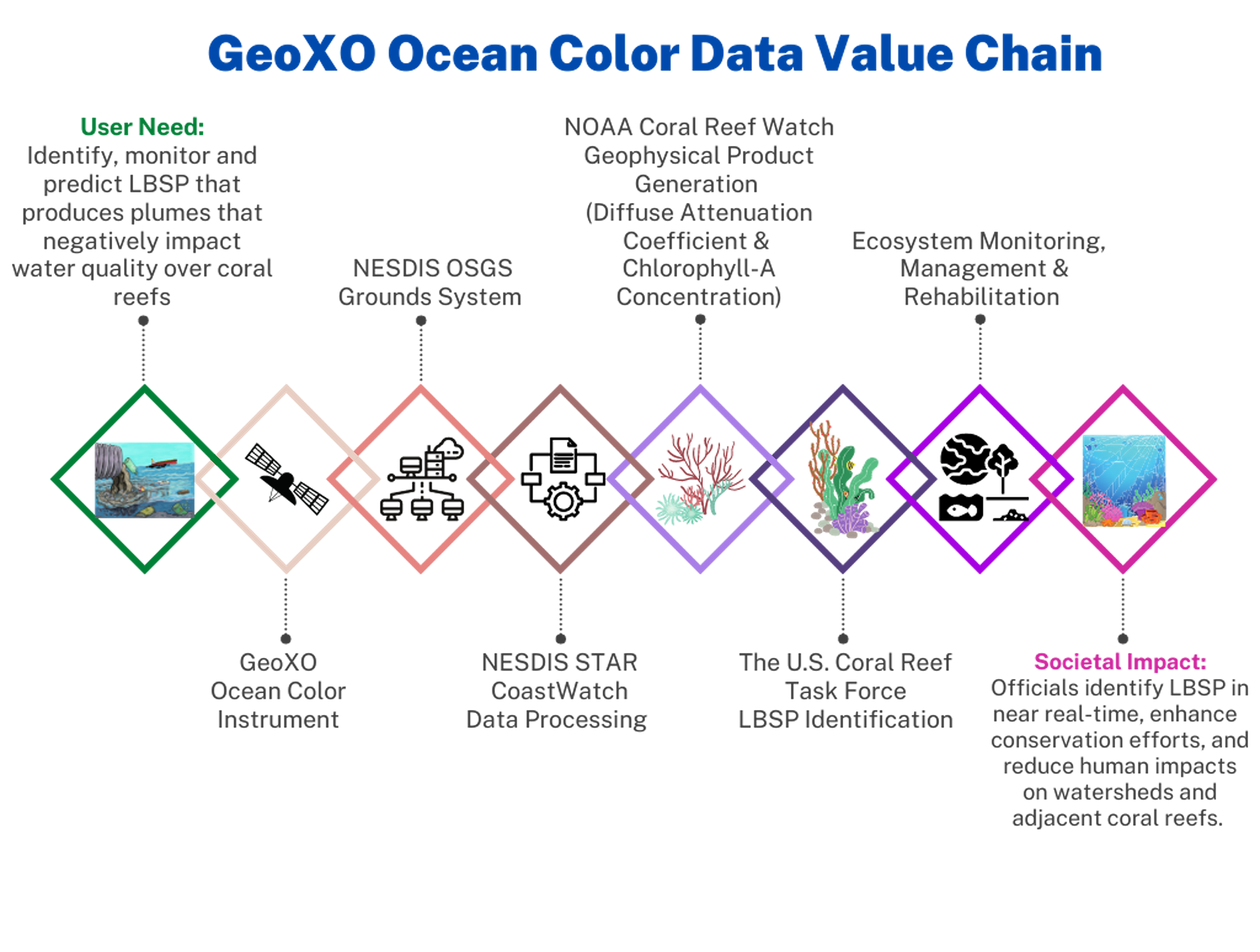
Monitoring Land-Based Pollution
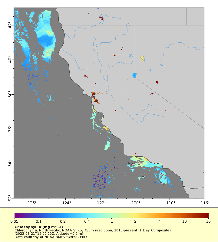
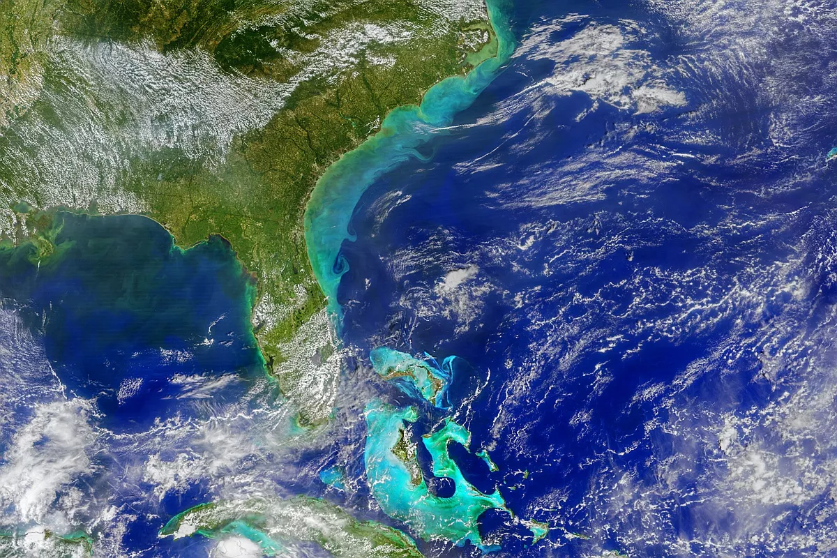
Land-based sources of pollution (LBSP) from coastal development, deforestation, agricultural runoff, and oil and chemical spills produce many serious coral reef ecosystem stressors, most notably toxicants, sediments, and excess nutrients. These can impede coral growth and reproduction, disrupt overall ecological function, and cause disease and mortality in sensitive species. LBSP is typically caused by coastal and upstream land development (but can also form from natural land erosion). It is identifiable by a significant increase in water turbidity (the measure of relative clarity of a liquid), especially following significant precipitation events that result in plume events. Ocean color data is used to track LBSP by identifying plume signatures, which helps identify health threats to coral reef ecosystems. With the improved temporal (hourly) and spatial (300 m) resolutions OCX will offer, scientists and watershed managers will see LBSP events unfold and could respond more quickly, leading to more effective response rates.
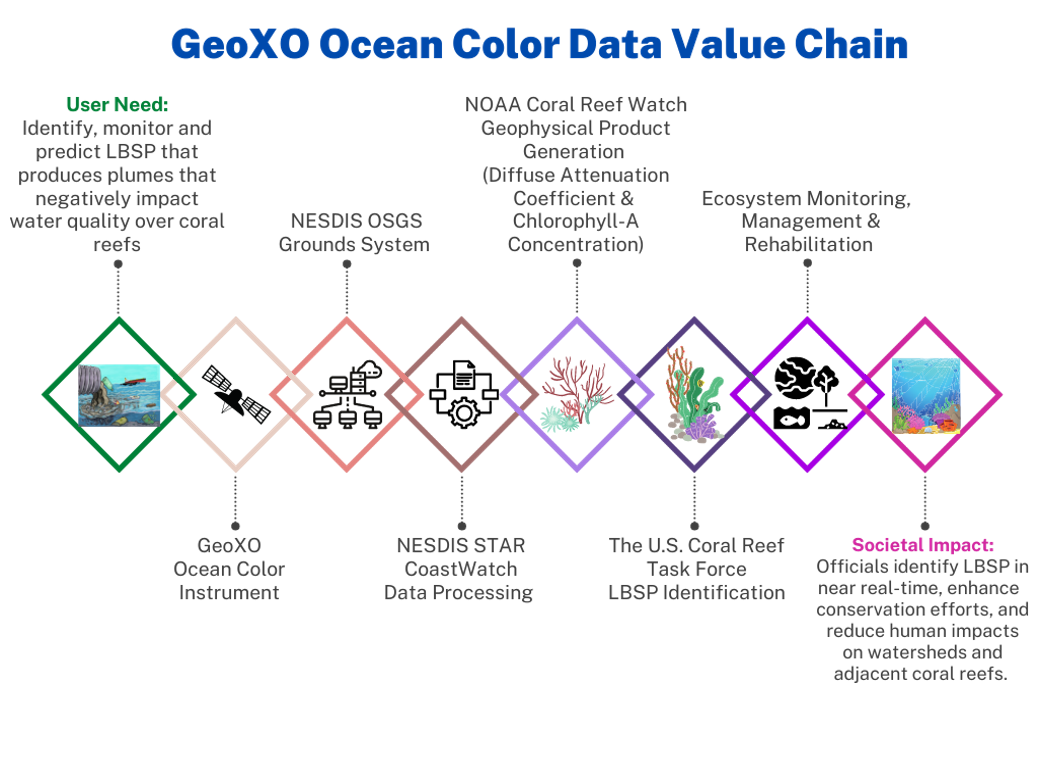
NOAA’s land-based sources of pollution value chain
OCX Value Assessment Report
Learn more about the benefits of geostationary ocean color observations in NOAA’s Technical Report: The Value of Geostationary Ocean Color.
OCX Status
On May 20, 2024, NASA selected BAE Systems of Boulder, Colorado, to develop NOAA’s GeoXO Ocean Color instrument. The contract includes the development of one flight instrument as well as options for additional units. The contract scope includes the tasks and deliverables necessary to design, analyze, develop, fabricate, integrate, test, verify, evaluate, support launch, supply and maintain the instrument ground support equipment, and support mission operations at the NOAA Satellite Operations Facility.
Related Links
- NOAA Podcast: The Mystery of Harmful Algal Blooms
- NOAA Podcast: Dealing with Dead Zones: Hypoxia in the Ocean
- NOAA Podcast: Harmful Algal Bloom Forecasting
- NOAA Podcast: Hypoxia
- NOAA Podcast: Ocean Economy
- NOAA’s Coral Reef Watch
- NOAA’s Coral Reef Conservation Program
- National Ocean Service HAB Forecasting
The information on this page is subject to change as the GeoXO program develops.