

With GeoXO, made-to-order data delivery will allow users to customize data access to facilitate more accessible and usable environmental information. Multiple data delivery options will be available, including an internet storefront, mobile device access, and satellite broadcast. Cloud-based product generation will expand data access, increase community involvement, and continuously evolve service.
File format, product delivery, and access play a large role in meeting data users’ needs. As a result of user engagement efforts, data in geographic information system (GIS) formats will soon be available across all NOAA geostationary satellite data, well ahead of the first GeoXO launch.
GeoXO planned data distribution diagram.
The Future of Data Delivery
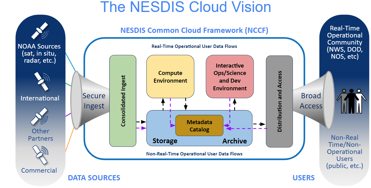
The extent of cloud services and rapid adoption by government agencies makes the cloud a clear solution for GeoXO data storage and distribution applications. All GeoXO data products will be available directly from the NESDIS Common Cloud Framework (NCCF). NCCF is a suite of services that allows NESDIS to provide end-to-end ground service capabilities to ingest, process, analyze, distribute, and store all types of NESDIS data for faster, easier dissemination of data to NESDIS partners and consumers. GeoXO data will be sent directly from the NCCF to the weather and forecasting community via low-latency dissemination service. GeoXO data will also be made available to the public through a consolidated storefront portal where users can search across all NESDIS archived data, including GOES and GOES-R Series data.
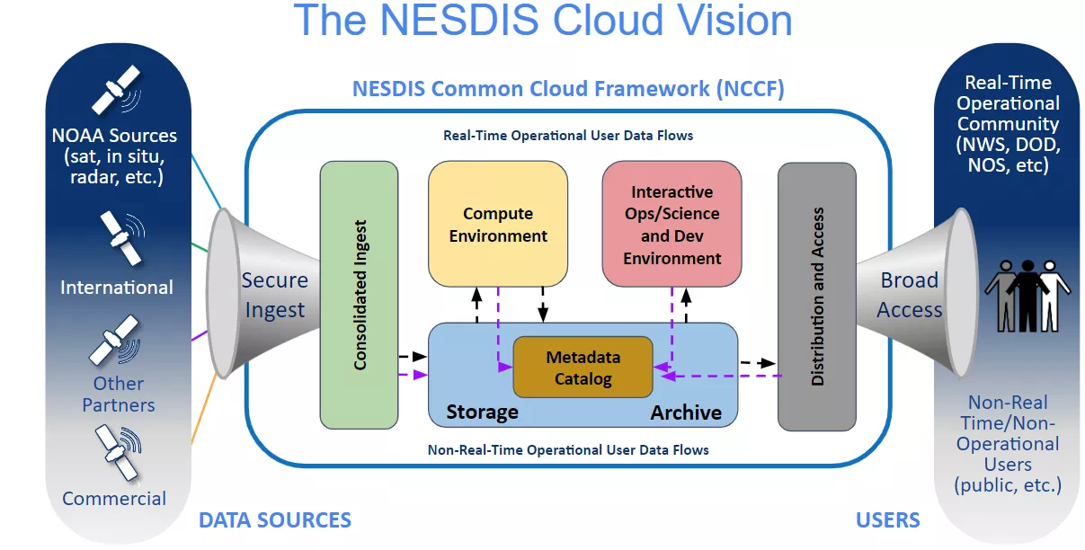
NESDIS Common Cloud Framework.
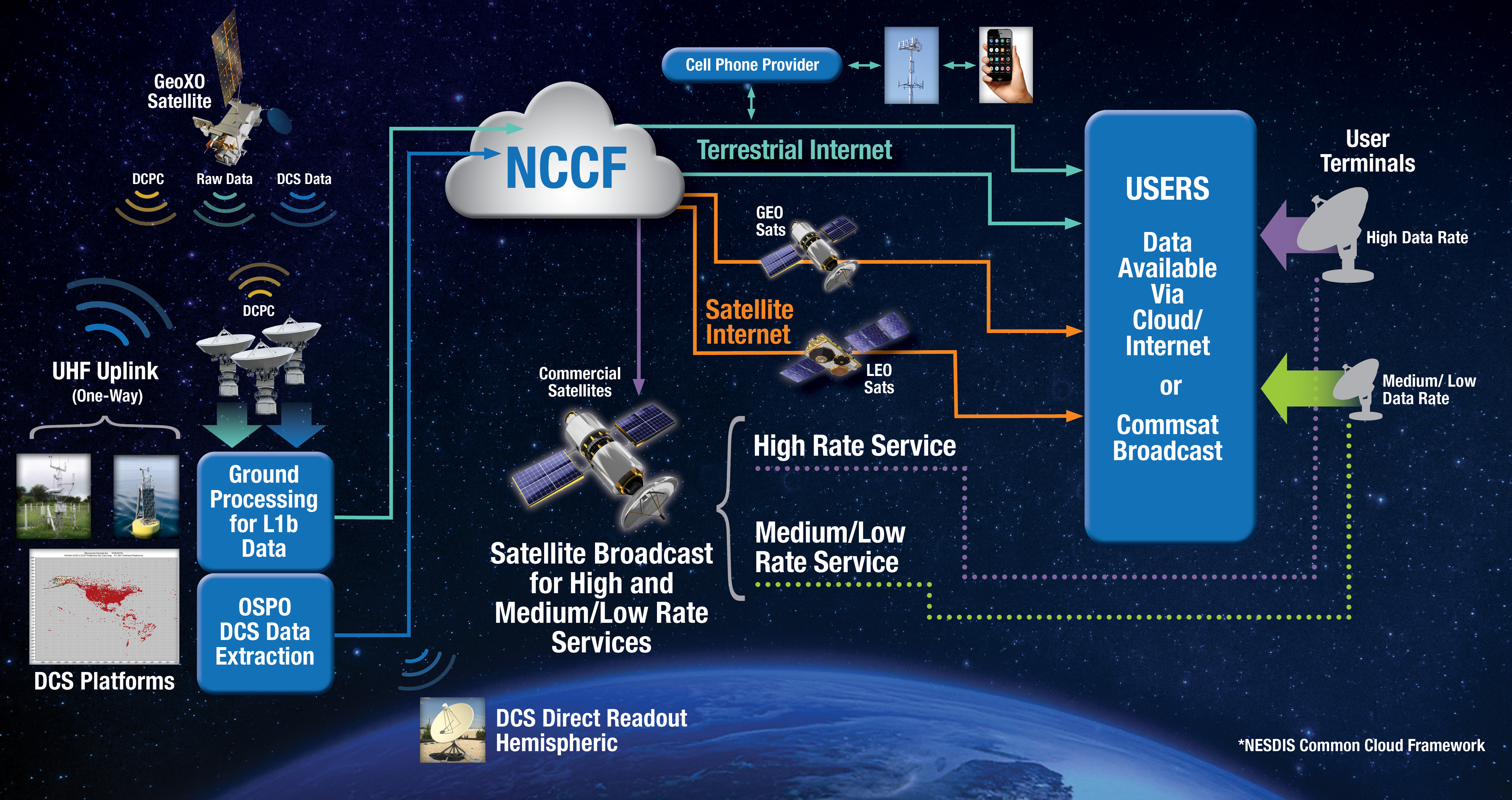
Operational GeoXO data will flow from NOAA’s Office of Satellite and Product Operations (OSPO) via terrestrial networks. Radio Frequency (RF) broadcast of a subset of the instrument data will be provided through commercial satellite broadcast. Both a high-rate and medium/low-rate service is planned, with the high rate having data content similar to the GOES Rebroadcast service, and the medium/low rate content being similar to the GOES-R High Rate Information Transmission (HRIT)/Emergency Managers Weather Information Network (EMWIN) service.
The Data Collection System (DCS) data will be transmitted from the GeoXO East and West satellites for direct receipt by users with receive systems, and the DCS data will also be provided to NCCF for cloud and internet access. We anticipate a third delivery method for the DCS data will be to package it in the medium/low commercial RF service.
The information on this page is subject to change as the GeoXO program develops.