
What do severe storms like Sandy, Katrina, and Haiyan, as well as non-weather related incidents like the Deepwater Horizon spill and Fukushima nuclear accident have in common? They all demonstrate how important it is to understand our oceans during catastrophic events.
The Consortium for Ocean Leadership recently determined that analyses of the Earth's climate and weather systems show that critical advances in weather models are possible through enhanced monitoring of the dynamics between oceans and the atmosphere.
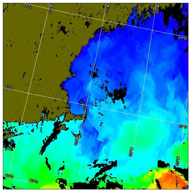
To that end, JPSS’ Visible Infrared Imager Radiometer Suite (VIIRS) instrument delivers the best combination of accuracy and global coverage of sea surface temperature (SST). VIIRS SST measurements, combined with data from other satellites and buoys, provide critical input to ocean-coupled models.
"The Consortium correctly identifies the importance of accurate and timely data in the computer models and how better prediction can help lessen the socio-economic impacts resulting from a severe storm," said Harry Cikanek, JPSS program director. "Adding data from JPSS satellites will improve our nation’s ability to prepare and become more resilient in the face of catastrophic weather events."
VIIRS imagery is not only able to track the formation and development of severe weather around the globe, but will also be able to detect and monitor the movement of oil during a spill. Additionally, VIIRS’ ocean color measurements provide information on ocean and coastal waters nutrients and toxicity, and are used in red-tide assessments, ecological forecasting of coastal and bay water quality. Persistently high SST measurements can also help identify areas prone to coral reef bleaching.
The VIIRS instrument, currently flying on board the Suomi NPP satellite and scheduled to launch aboard the JPSS-1 satellite in 2017, offers a new range of possibilities to visualize Earth and its oceans, while concurrently improving the quality of weather forecasts that save lives and protect local economies.
The Consortium for Ocean Leadership is a Washington, DC-based nonprofit organization that represents more than 100 of the leading public and private ocean research and education institutions, aquaria and industry with the mission to advance research, education and sound ocean policy.