NOAA plans to include an Atmospheric Composition instrument (ACX) that observes atmospheric composition data as part of the GeoXO satellite system. The GeoXO ACX will be a hyperspectral spectrometer that measures a wide spectrum of light from ultraviolet (UV) to visible.
ACX will provide hourly observations of air pollutants emitted by transportation, power generation, industry, oil and gas extraction, volcanoes, and wildfires, as well as secondary pollutants generated from these emissions once they are in the atmosphere.
By providing continuous observations and measurements of atmospheric composition, ACX data will improve air quality monitoring and forecasting as well as mitigate health impacts from severe pollution and smoke events. ACX will contribute to improved operational air quality, hazard, and wildfire observation and prediction efforts. These improvements can help save thousands of lives, reduce health care costs, and improve economic productivity.
NOAA’s atmospheric composition monitoring capabilities will be critical as we face increasingly complex and interconnected impacts from climate change and its consequences for the environment and our society. GeoXO ACX data will also help understand linkages between weather, air quality, and climate.
Improvements Over Current Capabilities
Currently, NOAA measurements of atmospheric composition changes in the planetary boundary layer from space are limited to one observation per day from polar-orbiting satellites. Having an atmospheric composition instrument aboard a geostationary satellite will extend the capability to observe rapidly-changing air quality during the day. This can help reduce the adverse impacts of poor air quality, enhancing the protection of ecosystems, and improving human health (e.g., examining how environmental factors relate to patterns of morbidity and mortality).
Benefits of a Geostationary Atmospheric Composition Instrument

ACX observations will support several science and operational application areas. These application areas will be informed by the GeoXO Imager (GXI) and GeoXO Sounder (GXS) instruments as well.
Air Quality Forecasting
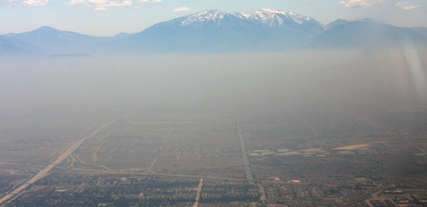
ACX will provide hourly tropospheric trace gas and aerosol observations. ACX data will be fundamental to understanding changes in air quality as well as their impacts on human health and natural and engineered ecosystems. The ability to continually monitor smog-inducing compounds that have a significant daily variation would enhance air quality forecasts.
More continuous data would mean less data lost from cloud contamination (clouds that block readings) and may provide improved inputs to forecast models (e.g., better detection of wildfires and their intensities helping to improve smoke emissions estimates). More accurate air quality forecasts over the U.S. would help to save lives and improve health outcomes because of reduced exposure to severe air pollution events.
Air Quality Monitoring

A robust space-based air quality monitoring capability from ACX will provide complementary measurements to existing surface networks and emissions monitoring operated by national, tribal, state, and local regulatory agencies. High spatial and temporal resolution ACX measurements will be sensitive to the amount and changes of gases and aerosols in the planetary boundary layer.
About 100,000 premature deaths annually in the U.S. result from poor air quality. The components of air pollution, such as near-surface ozone and fine particulate matter have myriad impacts on respiratory and cardiovascular health. Poor visibility, particularly from dust or smoke from wildfires, impacts air and ground transportation. ACX continuous measurements will provide better forecasts for these components.
Highest Priority Factors for Air Quality Monitoring:
- Ozone (O3)
- Particulate matter (PM)
- Nitrogen dioxide (NO2)
- Formaldehyde (CH2O)
- Glyoxal (C2H2O2)
- Sulfur dioxide (SO2)
Hazards Forecasting
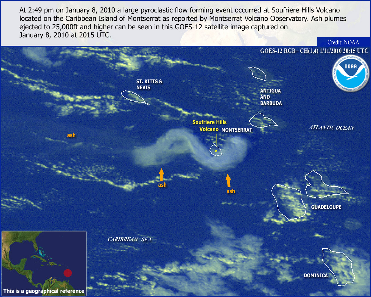
NOAA is responsible for forecasting episodic, high-risk events, including volcanic emissions and chemical, toxic, and radioactive material. Volcanic Ash Advisories (VAAs) that are critically important to the aviation community combine observations from multiple satellites with model forecasts. ACX’s continuous observations of sulfur dioxide and hazardous materials released from refinery fires, railroad derailments, oil spills, and other industrial accidents will improve hazards forecasting.
Stratospheric Ozone Monitoring
NOAA is mandated by the Clean Air Act and the Montreal Protocol to monitor, assess, provide measurements of, and report on the state of the stratospheric ozone layer. The ozone layer protects all life on Earth from harmful UV radiation and plays an important role in atmospheric structure and large-scale circulation, which impacts weather on seasonal to sub-seasonal time scales and may be impacted by pollutants. ACX will provide continuous coverage of pollutant transport to the troposphere, which can also be associated with turbulence and affect aviation safety.
The ACX backscatter UV (BUV) can provide timely, high-resolution measurements of episodic, rapidly changing stratospheric events. Combining BUV with a GeoXO high-spectral resolution infrared sounder and in-situ stratospheric ozone measurements will provide continuous ozone climate data records.
Weather and Climate Forecasting
NOAA's forecasts predict changes in a variety of natural systems in response to drivers such as climate variability, extreme weather conditions, pollution caused by humans, natural disasters, and/or hazards.
ACX will capture ozone measurements, ozone and aerosol precursor data and provide an aerosol layer height. Aerosols and trace gasses affect weather and climate directly through their radiative impacts and, in the case of aerosols, indirectly through changes to clouds. More accurate data on atmospheric composition within the Unified Forecast System (UFS) will provide more accurate weather and climate forecasts.
Additional Benefits of ACX Data
Boundary layer: The planetary boundary layer is critical to understanding weather and climate, how heat is exchanged, water vapor and the dispersion of pollutants. ACX will enhance those observations indirectly through measurements of trace gases and more directly through aerosol layer height measurements.
Data accuracy enhanced: To obtain the most accurate data, geostationary satellites’ continuous view of areas allows for atmospheric column measurements while clouds pass, allowing more opportunities for cloud-free data. It’s especially important for regions with persistent cloudiness.
Energy budget: Earth's climate is determined by its energy budget, a delicate balance between how much of the sun's radiative energy is absorbed in the atmosphere and at the surface and how much thermal infrared radiation Earth emits to space.
Marine and coastal ecosystems: Protection of marine and coastal ecosystems requires the capacity to predict the current state of atmospheric composition and its changes over time. ACX will supplement the data from OCX, the GeoXO Ocean Color instrument.
ACX Value Assessment Report
Learn more about the benefits of geostationary atmospheric composition observations in NOAA’s Technical Report: A Value Assessment of an Atmospheric Composition Capability on the NOAA Next-Generation Geostationary Extended Observations (GeoXO) Mission
ACX Status
On May 17, 2022, NASA selected Ball Aerospace & Technologies Corp. of Boulder, Colorado, and Raytheon Intelligence & Space of El Segundo, California, to conduct ACX Phase A Studies. Each company conducted a definition-phase study of a geostationary atmospheric composition instrument.
The results of these studies were used to set performance requirements for the ACX instrument development contract. NASA posted the request for proposals for ACX development on Oct. 23, 2023. NASA plans to select a development contractor for ACX around late April 2024.
Related Links
- National Weather Service Air Quality Prediction
- Get your current air quality index
- Hourly Air Quality Forecasts
- What to do during an air quality alert
- National Air Quality Forecast Capability (NAQFC)
- AerosolWatch
The information on this page is subject to change as the GeoXO program develops.