Last summer, Lake Erie became the first site in the Great Lakes—and the first site in U.S. inland waters—to participate in an international effort that provides data on ocean radiance for use in scientific research and validating satellite-derived measurements of ocean color.
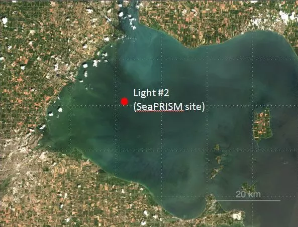
Last summer, the western end of Lake Erie became the first site in the Great Lakes—and the first site in U.S. inland waters—to participate in the Aerosol Robotic Network’s Ocean Color (AERONET-OC) program, an international effort that provides data on ocean radiance for use in scientific research and validating satellite-derived measurements of ocean color.
“Ocean color” refers to the various hues that ocean waters acquire in the presence of algae, bacteria, plankton, sediments, or other organic material. Satellites can “see” these colors by measuring the wavelengths of light the Earth’s waters absorb and reflect, information that scientists can then use in several ways, including monitoring harmful algal blooms (HBAs), detecting the presence of phytoplankton, and evaluating concentrations of organic carbon.
For the data from Earth-observing satellites to be accurate and credible, the influence of atmospheric characteristics on radiation measurements needs to be accounted for (i.e., an “atmospheric correction”). One way to do this is to validate satellite data by comparing it to data from in-situ or ground-based sensors.
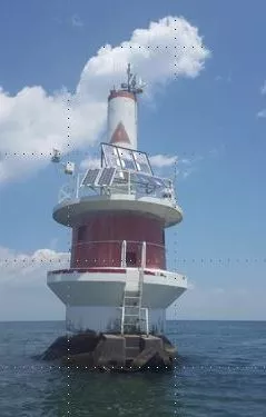
AERONET-OC provides this validation through the installation of photometers—devices that can detect the wavelengths of light reflected by surface waters just like satellites—on offshore structures like lighthouses, oceanographic research stations, and oil platforms.
And so it was this past June, when a team of scientists from the University of New Hampshire (UNH), the European Commission’s Joint Research Center, NASA, and NOAA installed a photometer, known as a SeaPRISM, atop a US Coast Guard Light tower in Lake Erie’s western basin. By zeroing in on light reflected off the water in this part of the lake, the SeaPRISM provides scientists with data about the conditions of the basin’s water. In addition, this data can be compared with ocean-color data, or “lake-color” in this case, from Earth-observing satellite instruments such as the Visible Infrared Imager and Radiometer Suite (VIIRS) on the Joint Polar Satellite System’s Suomi NPP satellite.
In mid-July, scientists began analyzing the data from the Lake Erie SeaPRISM and, although there were a few discrepancies, the University of New Hampshire’s Dr. Tim Moore, the project’s principal investigator, said the deployment of the device was “very successful.”
“It was a very active first month for the SeaPRISM. Twenty-five of 31 days had observations, with the SeaPRISM capturing [algal] bloom initiation, some floating algae, and several water masses as they drifted by,” Moore said. “The satellite validation exercise showed very good agreement with NOAA Science Quality VIIRS data.”
Good for VIIRS but there are other satellite instruments that are useful in monitoring algae in the Great Lakes, which is why the 9-channel SeaPRISM installed on the Coast Guard tower this past summer will be replaced with a 12-channel version in the summer of 2017. This upgrade will not only provide validation for VIIRS, but also will enhance researchers’ ability to validate the data from the multispectral, higher resolution Ocean and Land Color instruments aboard the European Space Agency’s Sentinel 3A satellite, as well as lend to the effort of using satellite data with even higher spatial resolution that are primarily intended for land observations.
There are now 27 AERONET-OC sites globally, with the Lake Erie site becoming the second AERONET-OC site in the world to be established in inland waters and the fourth site to be supported by NOAA. The other three NOAA-supported sites are in coastal waters around the United States, including Long Island Sound, the Gulf of Mexico and the along the coast of California near Catalina Island.
For more information on NOAA VIIRS Ocean Color, visit the STAR MECB Ocean Color website. For more information about NOAA’s Great Lakes, go to the website of the NOAA Great Lakes Environmental Research Laboratory. For more information on the AERONET program , visit its website.
Monitoring HABs from Space
“The most severe this century,†that was how scientists with NOAA CoastWatch and the Great Lakes Environmental Research Laboratory characterized the immense harmful algal bloom (HAB) in Lake Erie’s western basin during the summer of 2015.
Over a 40-day period from late July to the end of August, the amount of biomass associated with the HAB was the highest ever recorded. On August 5, dense green scum covered up to 300 square miles of the lake’s western basin—and then it happened a second time on August 15.
To keep tabs on the size and location of these HABs, the scientists rely on data from polar-orbiting satellites, a tactic that researchers have been using for nearly 30 years.
These forecasts, which combine the chlorophyll (the primary pigment in the algae that makes it look green) data with wind, water current and other information are useful to health officials, resources managers, and others who works to provide communities with water that is safe for consumption and recreation.
Click here to learn more about how satellites are used in the monitoring and forecasting of harmful algal blooms.