NOAA has been using its satellites to monitor the massive iceberg, A-68A, in the South Atlantic Ocean since it broke off (calved) from the Larsen-C Ice Shelf in Antarctica on July 12, 2017. At the time, it was larger than the state of Delaware, and has remained one of the largest icebergs in the world.
Recently, A-68A appeared to be floating toward the island of South Georgia, one of the world's largest marine conservation areas and important fishing grounds. It was feared that the iceberg would plow up the seabed in the shallows off the coast of the island, causing considerable environmental damage and disrupting the feeding patterns of the millions of king and macaroni penguins as well as seals who reside there. It is also releasing 27,000 cubic feet of fresh water per second into the sea, which is 12 times the outflow of the River Thames per second.
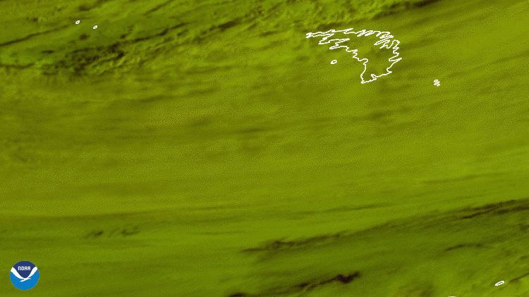
However, this satellite imagery from GOES East shows that as the iceberg approached the island (top right), it rotated clockwise and followed the current parallel to the island. Its northern end then broke off on Dec. 18 (forming A-68D), followed by two more massive pieces that broke off (A-68E and A-68F) three days later. Scientists are watching to see if any of these smaller pieces will drift closer to South Georgia, possibly running aground.
The coloring in this imagery looks different because it is utilizing an image product called Day Snow/Cloud Layers, which combines six different bands on the satellite's Advanced Baseline Imager (ABI) to help distinguish clouds from snow and ice. By doing this, snow appears as white, low moisture-rich clouds appear yellowish-green, and high cirrus clouds appear pink.
The GOES East geostationary satellite, also known as GOES-16, keeps watch over most of North America, including the continental United States and Mexico, as well as Central and South America, the Caribbean, and the Atlantic Ocean to the west coast of Africa. The satellite's high-resolution imagery provides optimal viewing of severe weather events, including thunderstorms, tropical storms, and hurricanes.